Auxerre
| Auxerre | ||
|---|---|---|
|
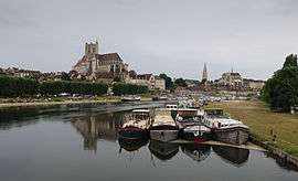
Auxerre and Yonne river | ||
| ||
 Auxerre | ||
|
Location within Bourgogne-Franche-Comté region  Auxerre | ||
| Coordinates: 47°47′55″N 3°34′02″E / 47.7986°N 3.5672°ECoordinates: 47°47′55″N 3°34′02″E / 47.7986°N 3.5672°E | ||
| Country | France | |
| Region | Bourgogne-Franche-Comté | |
| Department | Yonne | |
| Arrondissement | Auxerre | |
| Intercommunality | Auxerrois | |
| Government | ||
| • Mayor (2008–2020) | Guy Ferez | |
| Area1 | 49.95 km2 (19.29 sq mi) | |
| Population (2006)2 | 38,800 | |
| • Density | 780/km2 (2,000/sq mi) | |
| Time zone | CET (UTC+1) | |
| • Summer (DST) | CEST (UTC+2) | |
| INSEE/Postal code | 89024 / 89000 | |
| Elevation |
93–217 m (305–712 ft) (avg. 102 m or 335 ft) | |
|
1 French Land Register data, which excludes lakes, ponds, glaciers > 1 km² (0.386 sq mi or 247 acres) and river estuaries. 2 Population without double counting: residents of multiple communes (e.g., students and military personnel) only counted once. | ||
.svg.png)
Auxerre (French pronunciation: [oˈsɛʁ]) is the capital of the Yonne department and the fourth-largest city in Burgundy. Auxerre's population today is about 39,000;[1] the metropolitan area comprises roughly 92,000 inhabitants. Residents of Auxerre are referred to as Auxerrois.
Auxerre is a commercial and industrial centre, with industries including food production, woodworking and batteries. It is also noted for its production of Burgundy wine, including world-famous Chablis. In 1995 Auxerre was named "Town of Art and History".[2]
History

Auxerre was a flourishing Gallo-Roman centre, then called Autissiodorum, through which passed one of the main roads of the area, the Via Agrippa (1st century AD) which crossed the Yonne River (Gallo-Roman Icauna) here. In the third century it became the seat of a bishop[3] and a provincial capital of the Roman Empire. In the 5th century it received a Cathedral. In the late 11th-early 12th century the existing communities were included inside a new line of walls built by the feudal counts of Auxerre.
Bourgeois activities accompanied the traditional land and wine cultivations starting from the twelfth century, and Auxerre developed into a commune with a Town Hall of its own. The Burgundian city, which became part of France under King Louis XI, suffered during the Hundred Years' War and the Wars of Religion. In 1567 it was captured by the Huguenots, and many of the Catholic edifices were damaged. The medieval ramparts were demolished in the 18th century.
In the 19th century numerous heavy infrastructures were built, including a railway station, a psychiatric hospital and the courts, and new quarters were developed on the right bank of the Yonne.
Up until recently, Auxerre was one of the most prosperous cities in the country.
Climate
| Climate data for Auxerre (1981–2010) | |||||||||||||
|---|---|---|---|---|---|---|---|---|---|---|---|---|---|
| Month | Jan | Feb | Mar | Apr | May | Jun | Jul | Aug | Sep | Oct | Nov | Dec | Year |
| Record high °C (°F) | 16.8 (62.2) |
23.0 (73.4) |
26.6 (79.9) |
29.8 (85.6) |
32.1 (89.8) |
37.7 (99.9) |
39.6 (103.3) |
41.1 (106) |
35.3 (95.5) |
31.3 (88.3) |
22.8 (73) |
18.4 (65.1) |
41.1 (106) |
| Average high °C (°F) | 6.3 (43.3) |
7.9 (46.2) |
12.2 (54) |
15.6 (60.1) |
19.8 (67.6) |
23.0 (73.4) |
26.1 (79) |
25.8 (78.4) |
21.5 (70.7) |
16.6 (61.9) |
10.2 (50.4) |
6.7 (44.1) |
16.0 (60.8) |
| Daily mean °C (°F) | 3.6 (38.5) |
4.4 (39.9) |
7.8 (46) |
10.5 (50.9) |
14.5 (58.1) |
17.7 (63.9) |
20.2 (68.4) |
20.0 (68) |
16.3 (61.3) |
12.4 (54.3) |
7.1 (44.8) |
4.1 (39.4) |
11.6 (52.9) |
| Average low °C (°F) | 0.8 (33.4) |
0.9 (33.6) |
3.3 (37.9) |
5.3 (41.5) |
9.2 (48.6) |
12.3 (54.1) |
14.4 (57.9) |
14.1 (57.4) |
11.0 (51.8) |
8.2 (46.8) |
4.0 (39.2) |
1.6 (34.9) |
7.1 (44.8) |
| Record low °C (°F) | −20.2 (−4.4) |
−18.8 (−1.8) |
−11.6 (11.1) |
−5.2 (22.6) |
−1.0 (30.2) |
3.0 (37.4) |
5.8 (42.4) |
4.0 (39.2) |
0.5 (32.9) |
−2.9 (26.8) |
−8.8 (16.2) |
−15.1 (4.8) |
−20.2 (−4.4) |
| Average precipitation mm (inches) | 56.3 (2.217) |
47.7 (1.878) |
48.9 (1.925) |
56.0 (2.205) |
69.5 (2.736) |
61.5 (2.421) |
53.9 (2.122) |
59.3 (2.335) |
61.1 (2.406) |
70.8 (2.787) |
61.1 (2.406) |
61.2 (2.409) |
707.3 (27.846) |
| Average precipitation days (≥ 1.0 mm) | 11.23 | 9.64 | 10.63 | 9.93 | 11.30 | 9.67 | 7.60 | 7.77 | 8.47 | 10.30 | 11.00 | 11.57 | 119.11 |
| Average relative humidity (%) | 87 | 82 | 77 | 72 | 76 | 74 | 71 | 73 | 78 | 85 | 87 | 88 | 79.2 |
| Mean monthly sunshine hours | 61.7 | 89.2 | 135.2 | 173.9 | 198.0 | 213.9 | 245.2 | 229.6 | 177.2 | 121.2 | 70.1 | 53.3 | 1,768.5 |
| Source #1: Meteo climat[4][5] | |||||||||||||
| Source #2: Infoclimat.fr (humidity, 1961–1990)[6] | |||||||||||||
Main sights
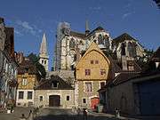
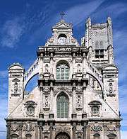
- Cathedral of St. Étienne (11th–16th centuries). In Gothic style, it is renowned for its three doorways with remarkable bas-reliefs. The stained glass windows in the choir and the apsidal chapel are among the finest in France. The 11th century crypt houses the remains of the former Romanesque cathedral.
- Abbey of Saint-Germain, existing from the ninth century. The crypt has some of the most ancient mural paintings in France, and houses the tomb of the bishops of Auxerre. Also interesting are the chapter room (12th century), the cellar (14th century) and the cloister (seventeenth century).
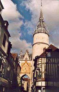
- The Clock tower, located in the Old Town
- The church of St. Pierre en Vallée (17th–18th centuries), established over a 6th-century abbey. In the style of late Gothic architecture, it has a tower similar to that of the cathedral. Portions of the decorations and inner chapels were financed by local winegrowers.
- Church of St. Eusèbe, founded in the 7th century. The nave was rebuilt in the 13th century, while the tower is in Romanesque style.
Personalities
- Saint Helladius (d. 387), bishop of Auxerre
- Saint Patrick (5th Century AD), Apostle to the Irish, visited Bishop Germanus of Auxerre here. According to the city's archives, it is said that St Patrick possibly studied in Auxerre for about 2 years.
- Jean Baptiste Joseph Fourier, (1769–1830), born in Auxerre, mathematician, experimental physicist, and politician.[7]
- Théodore Frédéric Gaillardet, (1808–1882), born in Auxerre, journalist, publisher of French-language newspaper Courrier des Etats-Unis in New York City, mayor of Plessis-Bouchard, France.[8]
- Eugène Hatin (1809–1893), historian and bibliographer
- Paul Bert (1833-1886), born in Auxerre, physiologist and politician.
- Marie-Noël (1883-1967), born in Auxerre, poet.
- Paul Monceaux (1859–1941), born in Auxerre, historian
- Jean Paul Rappeneau (1932), born in Auxerre, film director.
- Guy Roux (1938), coach of AJ Auxerre for more than 40 years, holding the French record of 894 games in Ligue 1.
Specialties
- Gougère: Baked choux pastry made of dough mixed with cheese.
- Kir (cocktail): A traditional aperitive mixed drink from Burgundy – Bourgogne Aligoté and blackcurrant liquor.
- Boeuf bourguignon: a typical main dish made of beef and vegetables.
- Truffe bourguignonne: Truffles from Burgundy.
Famous regional wines
- Chablis wine: One of the best white wines in the country, made exclusively of Chardonnay in the Chablis AOC
- Saint-Bris AOC: The one and only white wine in Burgundy made of Sauvignon grapes, especially Sauvignon blanc and Sauvignon gris
- Irancy: Perhaps the best red wine from the surrounding area - light and flavourful, made of Pinot noir
- Bourgogne côte d'Auxerre: Belongs to the Burgundy AOC (wine), it is a light and fruity wine made of Chardonnay for the white wine and Pinot noir for the red.
- Crémant de Bourgogne: Sparkling wine following the tradition of Champagne, Crémant de Bourgogne has a strong production in and around Auxerre.
- Bourgogne Aligoté: Dry wine. Aligoté is the second most popular grape variety grown in Burgundy after Chardonnay.
The whole region of Burgundy produces over 200 million bottles per year.
International relations
Twin towns and sister cities
Auxerre is twinned with:
|
See also
- County of Auxerre
- Bishopric of Auxerre
- Cathédrale Saint-Étienne d'Auxerre
- Lady of Auxerre
- Saint Germanus of Auxerre
- Remigius of Auxerre
- William of Auxerre
- Communes of the Yonne department
- AJ Auxerre, the local football club
References
- ↑ Populations légales 2007 de la commune d’Auxerre, INSEE
- ↑ fr:Villes et Pays d'art et d'histoire
- ↑ Councils were held here in 578 and 1147.
- ↑ "Moyennes 1981/2010: Région Bourgogne" (in French). Météoclimat. Retrieved January 5, 2016.
- ↑ "STATION Auxerre" (in French). Météoclimat. Retrieved January 5, 2016.
- ↑ "Normes et records 1961-1990: Auxerre (89) - altitude 207m" (in French). Infoclimat. Retrieved January 5, 2016.
- ↑ Howard Eves (1990). An Introduction to the History of Mathematics (sixth ed.). Saunders College Publishing.
- ↑ Who Was Who in America, Historical Volume, 1607–1896. Chicago: Marquis Who's Who. 1963.
- ↑ "British towns twinned with French towns". Archant Community Media Ltd. Retrieved 2013-07-11.
External links
| Wikimedia Commons has media related to Auxerre. |
 Goyau, Georges (1913). "Sens". In Herbermann, Charles. Catholic Encyclopedia. New York: Robert Appleton Company.
- Auxerre Town Hall (French)
- Chisholm, Hugh, ed. (1911). "Auxerre". Encyclopædia Britannica (11th ed.). Cambridge University Press.
|