Avondale Railway Station
Avondale | ||||||||||||||||
|---|---|---|---|---|---|---|---|---|---|---|---|---|---|---|---|---|
| Auckland Transport Urban rail | ||||||||||||||||
 | ||||||||||||||||
| Location | Layard Street, Avondale | |||||||||||||||
| Owned by | KiwiRail and Auckland Transport | |||||||||||||||
| Line(s) | Western Line | |||||||||||||||
| Platforms | Side platform | |||||||||||||||
| Tracks | Mainline (2) | |||||||||||||||
| Construction | ||||||||||||||||
| Platform levels | 1 | |||||||||||||||
| Parking | Street parking only | |||||||||||||||
| Bicycle facilities | Yes | |||||||||||||||
| Other information | ||||||||||||||||
| Station code | AVD | |||||||||||||||
| History | ||||||||||||||||
| Opened | 1880 | |||||||||||||||
| Rebuilt | 2010 | |||||||||||||||
| Electrified | 25kV AC[1] | |||||||||||||||
| Traffic | ||||||||||||||||
| Passengers (2009) | 1,206 passengers/day | |||||||||||||||
| Services | ||||||||||||||||
| ||||||||||||||||
Avondale Railway Station is on the Western Line of the Auckland railway network. Relocated in 2008, the station can be accessed from St Jude St, Layard St, and Crayford St.
The proposed Avondale–Southdown Line would connect to the Western Line just east of the station.
History
- 1880: Opened as one of the original stations on the North Auckland Line.[2] The station was known as Whau for the first two years of its existence.[3]
- 1882: A post office opened as part of the station.[2]
- 1912: The post office closed.[2]
- 1914: The platform was upgraded to an island platform layout with a new building on the new platform.[2]
- 1915: A signal box was added.[2]
- 1966: The line to Morningside was double-tracked.[2]
- 1967: The signal box was removed after this section changed to centralised traffic control.[2]
- 1993: The platform was raised to meet the requirements of ex-Perth trains.[2]
- 1995: The station building was relocated to Swanson.[2]
- 2008: The footbridge was demolished, the platform removed and a temporary station erected 50m to the east of the site.
- 2010: A new station was constructed and the line double-tracked westward beyond Avondale. The station opened on 14 June.
- 2014: Platforms extended to 150m from 143m for the new electric AM[4] class EMU trains.
Upgrade and relocation
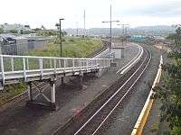
Until 26 December 2008 it had an island platform just west of Blockhouse Bay Road, reached via a footbridge off the road. In 2010 an upgraded station was built on Layard Street, north of the St Jude Street level crossing and approximately 100m west and 200m south of the old station.
The new station provides better connections with the Avondale town centre and the platform is on a straight section of track, unlike the old platform which was on a large sharp curve.[5]
Electrification work was completed and the station began serving electric trains in 2015.
Bus transfers
This station has number of bus routes pass through Rosebank Rd and Blockhouse Bay Rd for passengers to transfer:
| Previous major stop | AT Bus Services | Next major stop |
|---|---|---|
| New Lynn Terminus |
008 New Lynn–Otahuhu |
Mount Roskill Shops towards Otahuhu |
| New Lynn one way |
104 New Lynn local |
New Windsor towards New Lynn |
| Blockhouse Bay Shops towards New Lynn |
195 Green Bay–Downtown (via Great North Road) |
Point Chevalier Shops towards Britomart |
| Blockhouse Bay Shops towards Titirangi |
209 Titirangi–Downtown (via New North Road) |
Mount Albert towards Britomart |
| Rosebank Road Terminus |
221 Rosebank Rd–Midtown (via New North Road) |
Mount Albert towards Victoria Street West |
| Rosebank Road towards Patiki Road |
222 Patiki Rd–Midtown (via New North Road) | |
| New Lynn Terminus |
223 New Lynn–Midtown (via New North Road) | |
| New Lynn towards Henderson |
224 Henderson–Midtown (via New North Road) |
See also
References
Coordinates: 36°53′49.34″S 174°41′56.86″E / 36.8970389°S 174.6991278°E