Bacunayagua
| Bacunayagua | |
|---|---|
| Village | |
|
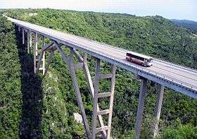
Bacunayagua Bridge, the tallest in Cuba | |
 Location of Bacunayagua in Cuba | |
| Coordinates: 23°7′56.67″N 81°40′45.32″W / 23.1324083°N 81.6792556°WCoordinates: 23°7′56.67″N 81°40′45.32″W / 23.1324083°N 81.6792556°W | |
| Country |
|
| Province | Matanzas |
| Municipality | Matanzas |
| Time zone | EST (UTC-5) |
| Area code(s) | +53-52 |
Bacunayagua is a placename in northern Cuba. It marks the boundary between the Mayabeque Province and Matanzas Province.
Geography
The small settlement, part of the municipality of Matanzas, was established on the side of the important Via Blanca (road), where a deep canyon cuts the coastal hills between the Yumuri Valley and the Straits of Florida coast.
Transport
Bacunayagua Bridge
The Bridge of Bacunayagua, inaugurated in September 1959, crosses the canyon, and at 110 meters above the valley floor is the highest bridge in Cuba.[1] Cubans consider it one of the seven wonders of Cuban civil engineering.[2] A restaurant with an observation deck is built on the Havana side, while the coastal cove on the Matanzas side includes a campground.
The bridge used to divide the provinces of La Habana and Matanzas, but after the reorganization of 2010, it now divides Matanzas Province from the new Mayabeque Province (the island's smallest, except for the city of Havana itself and the Isla de la Juventud).
See also
References
External links
| Wikimedia Commons has media related to Bacunayagua Bridge. |