Badito, Colorado
Badito, Colorado
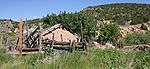
History
Badito, located at the crossing of the Huerfano River, marks a path used by the Ancient Pueblo Peoples during the Basketmaker era.

A Spanish expedition led by General Juan de Ulibarri is the first known recorded journey through Badito. He documented the journey through Cuchara Pass, west of the Spanish Peaks in 1706. Juan de Ulibarri's command reached the Rio de San Juan Baptista (currently named the Huerfano River) at Badito.
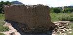
In 1819, Jacob Fowler noted an abandoned Spanish adobe fort at the location.
Later, the Taos Trappers Trail, joining the Santa Fe Trail with the Cherokee Trail, passed through this location. In 1867, as part of the U.S. Territories, Badito became the Huerfano County seat. Later the county seat was moved to Walsenburg.
References
Whiteley, Lee; The Cherokee Trail: Bent's Old Fort to Fort Bridger; Lee Whiteley; 1999; Johnson Printing; Boulder, Colorado; ISBN 0-9671351-1-7
Historic Marker #13; Posted by the Territorial Daughters of Colorado; Badito, Colorado.
Juan de Ulibarri; Jaun de Ulibarri's Diary; Translated and posted by the Territorial Daughters of Colorado; Badito, Colorado.
Coordinates: 37°43′38″N 105°00′51″W / 37.72722°N 105.01417°W