Baggot Street
Baggot Street (Irish: Sráid Bhagóid) is a street in Dublin, Ireland. It is named after Baggotrath, the manor granted to Robert Bagod in the 13th century. He built Baggotrath Castle, which was partly destroyed during the Battle of Rathmines and demolished in the early nineteenth century.The street was called Baggot Street in 1773.[1]
Location
The street runs from Merrion Row (near St. Stephen's Green) to the northwestern end of Pembroke Road. It crosses the Grand Canal near Haddington Road. It is divided into two sections:
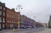
- Lower Baggot Street (Irish: Sráid Bhagóid Íochtarach) - between Merrion Row and the Grand Canal. It was called Gallows Road in the 18th century.[1]
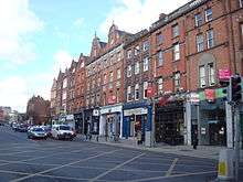
- Upper Baggot Street (Irish: Sráid Bhagóid Uachtarach) - south of the Grand Canal until the junction with Eastmoreland Place, where it continues as Pembroke Road.
Lower Baggot Street is distinguished by Georgian architecture, while Upper Baggot Street has mainly Victorian architecture with a few buildings of 20th century vintage. The Royal City of Dublin Hospital, Baggot Street, opened in 1834, is on the east side of Upper Baggot Street, just south of the junction with Haddington Road.[2] Cook's Map of 1836 shows the north side of Upper Baggot Street and Pembroke Road almost entirely built on.[2]
Activities
Baggot Street is known for its many pubs, and is home to the "Baggot Street Mile", a pub crawl which consists of having a pint in every pub on both Upper and Lower Baggot Street and some of the adjoining streets, usually at least twelve pubs in number. Depending on the variation, the Mile usually starts at the Den (at the Landsdowne Hotel, actually on Pembroke Road) and ends at the Pembroke (on Pembroke Street, now closed), O'Donoghues (Merrion Row) or The Horseshoe Bar (at the Shelbourne Hotel, St. Stephen's Green).[3] The Baggot Street Mile is a traditional route for the Twelve Pubs of Christmas pub crawl.[4]
People
- The Sheares Brothers, members of the Society of United Irishmen, who died in the 1798 rebellion, lived at no. 128.[1]
- In 1830, Thomas Davis, the revolutionary Irish writer who was the chief organizer and poet of the Young Ireland movement, lived at 67 Lower Baggot Street.[1]
- Catherine McAuley, a nun, founded the Sisters of Mercy order in 1831 and built what is now the Mercy International Centre on Lower Baggot Street where she later died in 1841.
- In 1909, Francis Bacon was born at 63 Lower Baggot Street.
- Singer-songwriter Sinéad O'Connor has a property here.
-
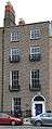
Francis Bacon's birthplace at 63 Baggot Street Dublin]]
-
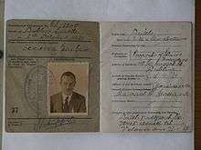
Pieter Jan Schippers, V-person during World War II was registered lower Baggot Street 118
See also
References
- 1 2 3 4 Carol and Jonathan Bardon: If Ever You Go To Dublin Town, Blackstaff Press, 1988 ISBN 0-85640-397-0
- 1 2 M. Donnelly, D.D: Short Histories of Dublin Parishes, part 2.
- ↑ "Pub Craaawl! Baggot Mile?". Boards.ie. Retrieved 21 December 2011.
- ↑ "The Baggot St Mile, Dublin". ratemypub.ie. Retrieved 21 December 2011.
External links
![]() Media related to Baggot Street Upper, Dublin at Wikimedia Commons
Media related to Baggot Street Upper, Dublin at Wikimedia Commons
![]() Media related to Baggot Street Lower, Dublin at Wikimedia Commons
Media related to Baggot Street Lower, Dublin at Wikimedia Commons
Coordinates: 53°19′58″N 6°14′32″W / 53.33278°N 6.24222°W