Baker Township, Izard County, Arkansas
| Baker Township | |
|---|---|
| Township | |
 Baker Township Location in Arkansas | |
| Coordinates: 36°13′33″N 91°49′41″W / 36.225927°N 91.828099°WCoordinates: 36°13′33″N 91°49′41″W / 36.225927°N 91.828099°W[1] | |
| Country | United States |
| State | Arkansas |
| County | Izard |
| Area[1] | |
| • Total | 20.122 sq mi (52.12 km2) |
| • Land | 20.122 sq mi (52.12 km2) |
| • Water | 0.000 sq mi (0.00 km2) |
| Elevation[2] | 617 ft (188 m) |
| Population (2010)[1] | |
| • Total | 203 |
| • Density | 10/sq mi (3.9/km2) |
| Time zone | CST (UTC-6) |
| • Summer (DST) | CDT (UTC-5) |
| FIPS code[2][3] | 05-90087 |
| GNIS ID[2][3] | 66693 |
Baker Township is a township in Izard County, Arkansas, United States.[4] Its total population was 203 as of the 2010 United States Census,[1][5] an increase of 0.5 percent from 202 at the 2000 census.[6][7]
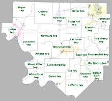
Townships in Izard County as of 2010
According to the 2010 Census, Baker Township is located at 36°13′33″N 91°49′41″W / 36.225927°N 91.828099°W (36.225927, -91.828099).[1] It has a total area of 20.122 square miles (52.12 square kilometers); all of which is land.[1] As per the USGS National Elevation Dataset, the elevation is 617 feet (188 m).[2]
Parts of the cities of Horseshoe Bend and Oxford are located within the township.[4]
References
- 1 2 3 4 5 6 "County Subdivisions (2010): Arkansas" (TXT). 2010 Census Gazetteer Files. United States Census Bureau. Retrieved May 31, 2014.
- 1 2 3 4 "Feature ID 66693: Township of Baker (Izard County, Arkansas)". Geographic Names Information System. United States Geological Survey. Retrieved May 31, 2014.
- 1 2 "FIPS55 Data: Arkansas". FIPS55 Data. United States Geological Survey. February 23, 2006. Archived from the original (TXT) on June 18, 2006. Retrieved May 31, 2014.
- 1 2 "Summary Population and Housing Characteristics, CPH-1-5, Arkansas" (PDF). 2010 Census of Population and Housing. United States Census Bureau. September 2012. Retrieved May 31, 2014.
- ↑ "2010 Demographic Profile (DP-1): Baker township, Izard County, Arkansas". American FactFinder. United States Census Bureau. Retrieved May 31, 2014.
- ↑ "2000 Demographic Profile (DP-1): Baker township, Izard County, Arkansas". American FactFinder. United States Census Bureau. Retrieved May 31, 2014.
- ↑ "County Subdivisions (2000)" (Zipped TXT). 2000 Census Gazetteer Files. United States Census Bureau. Retrieved May 31, 2014.
External links
- "2010 Census Block Map: Baker Township, Arkansas" (PDF). Arkansas 2010 Census Block Maps - County Subdivisions. U.S. Census Bureau.
- "2013 Boundary and Annexation Survey (BAS) Map: Izard County, Arkansas" (PDF). Boundary and Annexation Survey (BAS) Shapefiles and Maps. U.S. Census Bureau.
- "2010 Census County Subdivision Maps: Arkansas" (PDF). County Subdivision Maps. U.S. Census Bureau.
Municipalities and communities of Izard County, Arkansas, United States | ||
|---|---|---|
| Cities | 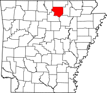 | |
| Towns | ||
| Unincorporated communities | ||
| Footnotes | ‡This populated place also has portions in an adjacent county or counties | |
This article is issued from Wikipedia - version of the 3/28/2016. The text is available under the Creative Commons Attribution/Share Alike but additional terms may apply for the media files.