Ballingham railway station
| Ballingham | |
|---|---|
|
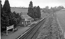
Ballingham railway station in 1961 | |
| Location | |
| Place | Ballingham |
| Area | Herefordshire |
| Grid reference | SO5535 |
| Operations | |
| Original company | Great Western Railway |
| Pre-grouping | Great Western Railway |
| Post-grouping | Great Western Railway |
| Platforms | 1 |
| History | |
| 1 September 1908[1] | Station opens |
| 2 November 1964 | Station closes |
| Disused railway stations in the United Kingdom | |
|
Closed railway stations in Britain A B C D–F G H–J K–L M–O P–R S T–V W–Z | |
|
| |
| Hereford, Ross | ||||||||||||||||||||||||||||||||||||||||||||||||||||||||||||||||||||||||||||||||||||||||||||||||||||||||||||||||||||||||||||||||||||||||||||||||||||||||||||||||||||||||||||||||||||||||||||||||||||||||||||||||||||||||||
|---|---|---|---|---|---|---|---|---|---|---|---|---|---|---|---|---|---|---|---|---|---|---|---|---|---|---|---|---|---|---|---|---|---|---|---|---|---|---|---|---|---|---|---|---|---|---|---|---|---|---|---|---|---|---|---|---|---|---|---|---|---|---|---|---|---|---|---|---|---|---|---|---|---|---|---|---|---|---|---|---|---|---|---|---|---|---|---|---|---|---|---|---|---|---|---|---|---|---|---|---|---|---|---|---|---|---|---|---|---|---|---|---|---|---|---|---|---|---|---|---|---|---|---|---|---|---|---|---|---|---|---|---|---|---|---|---|---|---|---|---|---|---|---|---|---|---|---|---|---|---|---|---|---|---|---|---|---|---|---|---|---|---|---|---|---|---|---|---|---|---|---|---|---|---|---|---|---|---|---|---|---|---|---|---|---|---|---|---|---|---|---|---|---|---|---|---|---|---|---|---|---|---|---|---|---|---|---|---|---|---|---|---|---|---|---|---|---|---|
Legend | ||||||||||||||||||||||||||||||||||||||||||||||||||||||||||||||||||||||||||||||||||||||||||||||||||||||||||||||||||||||||||||||||||||||||||||||||||||||||||||||||||||||||||||||||||||||||||||||||||||||||||||||||||||||||||
| ||||||||||||||||||||||||||||||||||||||||||||||||||||||||||||||||||||||||||||||||||||||||||||||||||||||||||||||||||||||||||||||||||||||||||||||||||||||||||||||||||||||||||||||||||||||||||||||||||||||||||||||||||||||||||
Ballingham railway station is a disused stone built railway station that served the villages of Ballingham and Carey in Herefordshire. It was situated between Ballingham Railway Bridge and Ballingham Tunnel, two of the most substantial structures on the Great Western Railway line which linked Ross-on-Wye and Hereford. Originally proposed by the owner of Ballingham Court[2] the station had a limited service and was never well used. It closed, along with the line, on 2 November 1964.
The station building has been extended and is now a private house.[2] The platform is still in existence.
References
- ↑ Smith, W H (1998) Herefordshire Railways Book, Sutton Publishing P21
- 1 2 http://www.wyevalleyhistory.net/LOWV%20history%20railways.htm
External links
| Preceding station | Disused railways | Following station | ||
|---|---|---|---|---|
| Fawley | Hereford, Ross and Gloucester Railway British Railways |
Holme Lacy | ||
Coordinates: 51°58′37″N 2°37′49″W / 51.97693°N 2.63034°W
This article is issued from Wikipedia - version of the 10/30/2016. The text is available under the Creative Commons Attribution/Share Alike but additional terms may apply for the media files.