Bandiat
| Bandiat | |
|---|---|
| Country | France |
| Basin | |
| Main source |
Haute-Vienne 440 m (1,440 ft) |
| River mouth |
Tardoire 45°46′41″N 0°20′21″E / 45.77806°N 0.33917°ECoordinates: 45°46′41″N 0°20′21″E / 45.77806°N 0.33917°E |
| Physical characteristics | |
| Length | 91.2 km (56.7 mi) |
| Discharge |
|
The Bandiat is a small river that is 91 km long, a left tributary of the Tardoire. It flows through the Haute-Vienne, Dordogne and Charente departments in France.
Geography
The Bandiat begins its course just south of the Puy Chauvet (488 m), at roughly 440 m above sea level, near the settlement of Grand Puyconnieux (commune of Dournazac) in the Haute-Vienne department. The river flows first to the southwest and then turns northwest in the Dordogne and, at high water level, empties into the Tardoire (Charente basin) near Agris in the Charente. Otherwise, the river disappears near Les Vieilles Vaures (commune of Agris) about 5 km before reaching the Tardoire. All the water drains away in several sinkholes in the karst only to reappear near Angoulême as springs of the river Touvre, a tributary of the Charente.
Hydrology
The discharge of the Bandiat was measured near Feuillade as 0.6 m³/s in the summer and 6 m³/s in the winter.
Communes by the river
Gallery
-
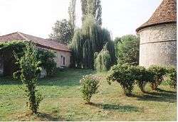
The same place in summer
-
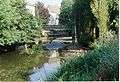
Drought in August, the mill is on the right
-
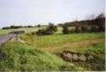
The area around Les Vieilles Vaures (commune of Agris) about 5 km from Agris. All water has disappeared in the karst of La Rochefoucauld
References
- http://www.geoportail.fr
- The Bandiat at the Sandre database
- Information about the river in Poitou-Charentes