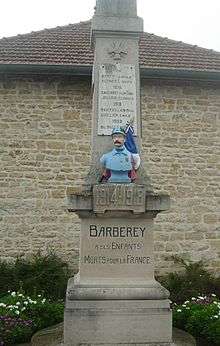
Barberey-Saint-Sulpice
| Barberey-Saint-Sulpice | |
|---|---|
|
The Canal Bridge | |
 Barberey-Saint-Sulpice | |
|
Location within Grand Est region  Barberey-Saint-Sulpice | |
| Coordinates: 48°20′19″N 4°01′57″E / 48.3386°N 4.0325°ECoordinates: 48°20′19″N 4°01′57″E / 48.3386°N 4.0325°E | |
| Country | France |
| Region | Grand Est |
| Department | Aube |
| Arrondissement | Troyes |
| Canton | Troyes-4 |
| Intercommunality | Seine Melda Coteaux |
| Government | |
| • Mayor (2001–2020) | Alain Hubinois |
| Area1 | 9.36 km2 (3.61 sq mi) |
| Population (2010)2 | 1,220 |
| • Density | 130/km2 (340/sq mi) |
| Time zone | CET (UTC+1) |
| • Summer (DST) | CEST (UTC+2) |
| INSEE/Postal code | 10030 / 10600 |
|
1 French Land Register data, which excludes lakes, ponds, glaciers > 1 km² (0.386 sq mi or 247 acres) and river estuaries. 2 Population without double counting: residents of multiple communes (e.g., students and military personnel) only counted once. | |
Barberey-Saint-Sulpice is a French commune in the Aube department in the Grand Est region of north-central France.
The inhabitants of the commune are known as Barberotins or Barberotines.[1]
Geography
Barberey-Saint-Sulpice is located to the immediate north-west of Troyes with the Troyes - Barberey Airport located in the commune. Access to the commune is by the D619 highway which starts at the end of the D319 highway at the edge of Troyes and continues north-west through the commune to Fontaine-les-Grès. The D20 also passes through the commune from Troyes going north-west to Saint-Lyé. The D60 from Troyes to Dierrey-Saint-Pierre passes through the south-western end of the commune. The D619 comes from Sainte-Maure in the north-east and passes through the centre of the commune and the town and continues south-west to join the D60 in the commune. The airport runway crosses three-quarters of the commune west of the D619 from north to south with access to the airport terminal by the Route de l'Aerodrome branching off the D619. The main railway line from Troyes to the north-west passes through the commune with a station in the town. Apart from a large urban area covering most of the north-west of the commune and the airport occupying the centre, the rest of the commune is farmland.[2]
The Seine river passes through the north-east of the commune as it flows north-west to eventually reach Paris and the Atlantic ocean at Le Havre. The former Canal de la Haute-Seine begins in the commune and follows the Seine to eventually join the Aube at Marcilly-sur-Seine.[2]
Neighbouring communes and villages[2]
 |
Saint-Lyé | Saint-Benoît-sur-Seine | Sainte-Maure | |
| Grange-l'Eveque | |
Lavau | ||
| ||||
| | ||||
| Montgueux | Les Noës-près-Troyes | Troyes |
Administration

| From | To | Name | Party | Position |
|---|---|---|---|---|
| 1857 | Gallice d'Ambly | |||
| 1887 | Parigot | |||
| 2001 | 2020 | Alain Hubinois |
(Not all data is known)
Demography
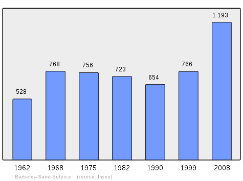
In 2010 the commune had 1,220 inhabitants. The evolution of the number of inhabitants is known from the population censuses conducted in the commune since 1793. From the 21st century, a census of communes with fewer than 10,000 inhabitants is held every five years, unlike larger communes that have a sample survey every year.[Note 1]
| 1793 | 1800 | 1806 | 1821 | 1831 | 1836 | 1841 | 1846 | 1851 |
|---|---|---|---|---|---|---|---|---|
| 256 | 224 | 282 | 293 | 328 | 358 | 410 | 432 | 456 |
| 1856 | 1861 | 1866 | 1872 | 1876 | 1881 | 1886 | 1891 | 1896 |
|---|---|---|---|---|---|---|---|---|
| 352 | 339 | 333 | 313 | 296 | 325 | 317 | 271 | 271 |
| 1901 | 1906 | 1911 | 1921 | 1926 | 1931 | 1936 | 1946 | 1954 |
|---|---|---|---|---|---|---|---|---|
| 292 | 291 | 298 | 358 | 381 | 433 | 473 | 530 | 554 |
| 1962 | 1968 | 1975 | 1982 | 1990 | 1999 | 2006 | 2010 | - |
|---|---|---|---|---|---|---|---|---|
| 528 | 768 | 756 | 723 | 654 | 766 | 1,064 | 1,220 | - |
Sources : Ldh/EHESS/Cassini until 1962, INSEE database from 1968 (population without double counting and municipal population from 2006)
Culture and heritage
Civil heritage
The commune has a number of buildings and sites that are registered as historical monuments:
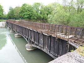
- A Canal Bridge over the Seine (1847)
 [4]
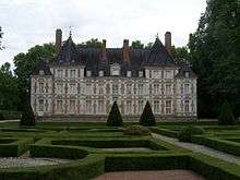
[4] - A Chateau (1626)[5]
- The Huot Mill (now a hydro-electric power station) (19th century)[6] The Mill contains an Hydraulic Turbine (20th century) which is registered as an historical object.
 [7]
[7]
Religious heritage
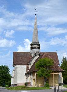
The Parish Church of Saint-Sulpice (12th century)![]() is registered as an historical monument.[8] has a Romanesque nave from the 12th century and a choir and transept from the 16th and 17th centuries. There is a wooden Renaissance tribune of twenty-five panels. The façade and porch are half-timbered.[9] The Church contains a very large number of items that are registered as historical objects.[Note 2]
is registered as an historical monument.[8] has a Romanesque nave from the 12th century and a choir and transept from the 16th and 17th centuries. There is a wooden Renaissance tribune of twenty-five panels. The façade and porch are half-timbered.[9] The Church contains a very large number of items that are registered as historical objects.[Note 2]
Notable people linked to the commune
- Claude-Louis Bruslé de Valsuzenay (6 December 1766 Paris - 2 March 1825 Paris), French politician and senior official in the 18th and 19th centuries, Châtelain of Barberey.
See also
Notes
- ↑ At the beginning of the 21st century, the methods of identification have been modified by Law No. 2002-276 of 27 February 2002, the so-called "law of local democracy" and in particular Title V "census operations" allows, after a transitional period running from 2004 to 2008, the annual publication of the legal population of the different French administrative districts. For communes with a population greater than 10,000 inhabitants, a sample survey is conducted annually, the entire territory of these communes is taken into account at the end of the period of five years. The first "legal population" after 1999 under this new law came into force on 1 January 2009 and was based on the census of 2006.
- ↑ For a complete list including links to descriptions (in French) and photos click here
References
- ↑ Inhabitants of Aube (French)
- 1 2 3 Google Maps
- ↑ List of Mayors of France (French)
- ↑ Ministry of Culture, Mérimée PA00078050 Canal Bridge (French)
- ↑ Ministry of Culture, Mérimée PA00078048 Chateau (French)

- ↑ Ministry of Culture, Mérimée IA10000284 Huot Mill (French)
- ↑ Ministry of Culture, Palissy IM10001357 Hydraulic Turbine (French)
- ↑ Ministry of Culture, Mérimée PA00078049 Church (French)
- ↑ Marguerite Beau, Essay on the religious architecture of southern Champagne in Aube except Troyes, 1991 (French)
External links
- Barberey-Saint-Sulpice official website (French)
- Barberey-Saint-Sulpice on the old National Geographic Institute website (French)
- Community of Communes Seine Melda Coteaux official website (French)
| Wikimedia Commons has media related to Barberey-Saint-Sulpice. |