Bare Island (New South Wales)
|
Footbridge from La Perouse leading to Bare Island | |
 Bare Island | |
| Geography | |
|---|---|
| Location | Botany Bay |
| Coordinates | 33°59′32″S 151°13′52″E / 33.99222°S 151.23111°ECoordinates: 33°59′32″S 151°13′52″E / 33.99222°S 151.23111°E |
| Administration | |
|
Australia | |
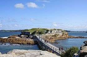
Bare Island is an islet[1] in south-eastern Sydney, in the state of New South Wales, in eastern Australia. The islet is located about 16 kilometres (9.9 mi) south east of the Sydney central business district, within Botany Bay, close to the bay's northern headland. Containing fortification facilities, Bare Island is listed on the State Heritage Register and is significant as an almost completely intact example of late nineteenth century coastal defence technology.[2]
Bare Island is connected by a footbridge to the suburb of La Perouse. The historic military fort and tunnels can only be visited by guided tour. The waters around the island are popular with scuba divers.[3][4]
History

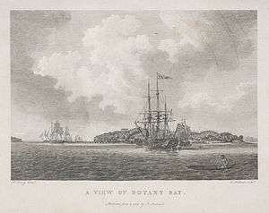
Bare Island was part of the traditional land of the Gweagal and Kameygal Aboriginal tribes. In 1770, it was described as ‘a small bare island’ by early explorer, Lieutenant James Cook.[5]
In 1877 it was decided that a fort was to be built on the island. Botany Bay was considered the back door into Sydney, thus making the city vulnerable to a seaborne attack. The construction of a fort on the island would reduce the odds of an attack from this entry point. Plans for the construction of a fort were drawn up by the Colonial Architects Department and tenders in 1880. Government tender for construction was awarded to John McLeod and Co, who also built the Georges Head and Middle Head fortifications. The fort was armed with two RML 9 inch 12 ton guns, two RML 80 pounder guns, a RML 10 inch 18 ton gun in an armoured casemate, and two five–barreled 0.45-inch (1.1 cm) Nordenfelt guns.[6]
Bare Island Fort was designed by Colonel Scratchley, the plans were prepared by Mr Morell, CE and supervised by the Colonial Architect James Barnet.[7] Construction of Bare Island fort was completed in 1885 at a cost of A£34,000; work inside the fort began in 1889.
In 1890 a Royal Commission found that construction of the fort was faulty due to the use of inferior concrete. The whole project started to crumble before it was completed. The Royal Commission was very critical of the material used and were reluctant to refer to the material as concrete. The two clerks who were responsible for the operation, Henry Purkis and Edwin Colley, were found to be neglectful in their duties of inspecting the site. The contractor responsible was asked to repay some of the money that was paid out to him. He was also banned from any other government contracts. Barnet was eventually blamed for failing to oversee the project and to limit the amount of extra funds paid out to the contractor. This led to his resignation in disgrace from government office.
Though bristling with guns, the fort was soon made redundant by advancing technology. By 1902 Bare Island was decommissioned and ceased to exist as a military fortification, with only a handful of military personnel manning the fort. In 1912, Bare Island became a retirement home for war veterans from the Crimea, Sudan, and China campaigns.[2] It continued to operate as a retirement home until 1963. Then the Randwick District Historical Society became caretakers of the island. In 1967 management of the site was transferred to the NSW National Parks & Wildlife Service for use as a museum and tourist attraction. The Bare Island fort has now been declared an historic site.[8]
Bare Island was featured in Mission: Impossible II and East West 101.
Recreation

Bare Island is the most popular scuba diving site in New South Wales. On a sunny summer Sunday there can be as many as 200 divers here during the day. It is a common diver training location and also very popular for snorkeling.
The reefs that stretch around the island and out to the south and west are home to some of Australia's most colourful marine animals. Things to be seen including big belly sea horses, sea dragons, pygmy pipehorses, red Indian fish and all the usual fish seen around Sydney. People have also seen seals and grey nurse sharks at times and in late winter Port Jackson sharks are very common.
See also
References
- ↑ "Bare Island". Geographical Names Register (GNR) of NSW. Geographical Names Board of New South Wales. Retrieved 8 October 2014.
- 1 2 "Bare Island Fort". NSW State Heritage Register. Government of New South Wales. 28 July 1999. Retrieved 8 October 2014.
- ↑ Pollen, Frances (1990). The Book of Sydney Suburbs. Australia: Angus & Robertson Publishers. ISBN 0-207-14495-8.
- ↑ "Bare Island - Dive Summary". Michael McFadyen's Scuba Diving Web.
- ↑ "Bare Island". Office of Environment & Heritage. Government of New South Wales. Retrieved 8 October 2014.
- ↑ "La Perouse, Botany Bay Batteries - Cape Banks, Henry Head, Bare Island". La Perouse.
- ↑ Bare Island Fort, La Perouse, NSW Profile Archived July 29, 2008, at the Wayback Machine.
- ↑ Randwick City Council » Bare Island Archived July 27, 2008, at the Wayback Machine.
External links
| Wikimedia Commons has media related to Bare Island (New South Wales). |