Barembach
| Barembach | ||
|---|---|---|
|
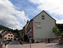
The Town Hall / School | ||
| ||
 Barembach | ||
|
Location within Grand Est region  Barembach | ||
| Coordinates: 48°28′37″N 7°13′51″E / 48.4769°N 7.2308°ECoordinates: 48°28′37″N 7°13′51″E / 48.4769°N 7.2308°E | ||
| Country | France | |
| Region | Grand Est | |
| Department | Bas-Rhin | |
| Arrondissement | Molsheim | |
| Canton | Mutzig | |
| Government | ||
| • Mayor (2001–2020) | Gérard Douvier | |
| Area1 | 9.92 km2 (3.83 sq mi) | |
| Population (2010)2 | 868 | |
| • Density | 88/km2 (230/sq mi) | |
| Time zone | CET (UTC+1) | |
| • Summer (DST) | CEST (UTC+2) | |
| INSEE/Postal code | 67020 / 67130 | |
| Elevation | 289–910 m (948–2,986 ft) | |
|
1 French Land Register data, which excludes lakes, ponds, glaciers > 1 km² (0.386 sq mi or 247 acres) and river estuaries. 2 Population without double counting: residents of multiple communes (e.g., students and military personnel) only counted once. | ||
Barembach is a French commune in the Bas-Rhin department in the Grand Est region of north-eastern France.[1]
The inhabitants of the commune are known as Barembachois or Barembachoises.[2]
Geography
Barembach is located in a valley perpendicular to the Bruche valley some 25 km west by south-west of Illkirch and 30 km north-west of Sélestat at 350 metres above sea level. The Barembach Forest covers most of the commune with several summits including Pépinière (666 metres), Barraque des Bœufs (781 metres), Ordon Saxe (690 metres), and Haut de la Brûlée (715 metres). Access to the commune is by the D204 road from Grendelbruch in the north-east which passes through the north-eastern corner of the commune and continues to Schirmeck. Access to the village is by the D193 which branches off the D204 in the commune. The D1420 from Muhlbach-sur-Bruche in the north-east passes along the northern border as it goes south-west to Fouday.[3][4]
The Barembach river rises in the south-east of the commune and flows north-west to join the Bruche just north-west of the commune. The Bornichon river rises in the south of the commune and flows north to join the Barembach at the village.[3]
Mapping
A list of online mapping systems can be displayed by clicking on the coordinates (latitude and longitude) in the top right hand corner of this article. None of these maps, however, show the extent of nor any information on the commune.
Neighbouring communes and villages
 |
Schirmeck | Russ | | |
| La Broque | |
Grendelbruch | ||
| ||||
| | ||||
| Rothau | Natzwiller |
History
Barembach was completely destroyed in 1875 by a violent fire. After the reconstruction of the village almost immediately after the disaster, the economy first restarted with livestock and forestry. There were also mills and sawmills producing galoshes which later changed to weaving. An enterprise was set up by Camille Glaszmann which specialised in Theatrical property. The company was sold in 1964 and continued by Mecatherm who extended the buildings. Shortly before Liberation the village was the headquarters of Marshal Jean de Lattre de Tassigny and served as a springboard to free the region. Barembach previously included part of the commune of Rothau on the north shore of the Rothaine.
Barembach appears as Barenbach on the 1750 Cassini Map[5] and the same on the 1790 version.[6]
The name Barembach originated from the German Bach meaning "stream" and Bär meaning "bear".
Heraldry
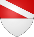 |
Blazon: Party per fess, at 1 Gules, a bend Argent; at 2 Argent. |
Administration
| From | To | Name | Party | Position |
|---|---|---|---|---|
| 2001 | 2020 | Gérard Douvier |
(Not all data is known)
Demography
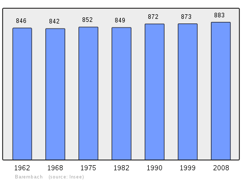
In 2010 the commune had 868 inhabitants. The evolution of the number of inhabitants is known from the population censuses conducted in the commune since 1793. From the 21st century, a census of communes with fewer than 10,000 inhabitants is held every five years, unlike larger communes that have a sample survey every year.[Note 1]
| 1793 | 1800 | 1806 | 1821 | 1831 | 1836 | 1841 | 1846 | 1851 |
|---|---|---|---|---|---|---|---|---|
| 532 | 571 | 768 | 744 | 945 | 1,011 | 1,040 | 1,030 | 1,086 |
| 1856 | 1861 | 1866 | 1872 | 1876 | 1881 | 1886 | 1891 | 1896 |
|---|---|---|---|---|---|---|---|---|
| 1,029 | 1,070 | 1,035 | 944 | 832 | 765 | 751 | 738 | 751 |
| 1901 | 1906 | 1911 | 1921 | 1926 | 1931 | 1936 | 1946 | 1954 |
|---|---|---|---|---|---|---|---|---|
| 829 | 899 | 862 | 756 | 775 | 788 | 812 | 794 | 853 |
| 1962 | 1968 | 1975 | 1982 | 1990 | 1999 | 2006 | 2010 | - |
|---|---|---|---|---|---|---|---|---|
| 846 | 842 | 852 | 849 | 872 | 873 | 891 | 868 | - |
Sources : Ldh/EHESS/Cassini until 1962, INSEE database from 1968 (population without double counting and municipal population from 2006)
Culture and heritage
Civil heritage
The commune has many buildings and sites that are registered as historical monuments:
- Houses and Farmhouses (19th century)
 [8]
[8] - The War Memorial at Route du Maréchal-De-Lattre-de-Tassigny (20th century)[9]
 [10]
[10] - A School at 14 Rue Principale (20th century)[11]
- The Town Hall / School at 15 Rue Principale (20th century)[12] The Town Hall / School contains several items that are registered as historical objects:
Religious heritage


The commune has several religious buildings and sites that are registered as historical monuments:
- The Barembach Cemetery on the D204 (19th century)[15] The Cemetery contains several items that are registered as historical objects:
- The Schirmeck Cemetery at Rue du Douar (19th century)[18] The Cemetery contains many items that are registered as historical objects:
- The Chartier Family Funeral Chapel on the D204 (20th century)[24]
- The Vogt Family Funeral Chapel at Rue du Douar (20th century)[25]
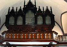
- The Church of Saint-Georges at Place de l'Eglise (1877)[26] The Church contains several items that are registered as historical objects:
- A Presbytery at 16 Rue du Presbytère (19th century)[31]
- 3 Wayside Crosses are registered as historical objects.[32]
Notable people linked to the commune
- Marshal Jean de Lattre de Tassigny had his headquarters in the village. The street from the cemetery to the church bears his name. There is a monument to him on this street near the church.
See also
Bibliography
- "Barembach", in The Upper Valley of the Bruche, Alsace Heritage, General Inventory of Monuments and artistic riches of France, Éditions Lieux Dits, Lyon, 2005, p. 38-39, ISBN 978-2-914528-13-9 (French)
Notes and references
Notes
- ↑ At the beginning of the 21st century, the methods of identification have been modified by Law No. 2002-276 of 27 February 2002, the so-called "law of local democracy" and in particular Title V "census operations" allows, after a transitional period running from 2004 to 2008, the annual publication of the legal population of the different French administrative districts. For communes with a population greater than 10,000 inhabitants, a sample survey is conducted annually and the entire territory of these communes is taken into account at the end of the period of five years. The first "legal population" after 1999 under this new law came into force on 1 January 2009 and was based on the census of 2006.
References
- ↑ Barembach on Lion1906
- ↑ Inhabitants of Bas-Rhin (French)
- 1 2 3 Barembach on Google Maps
- ↑ Barembach on the Géoportail from National Geographic Institute (IGN) website (French)
- ↑ Barenbach on the 1750 Cassini Map
- ↑ Barenbach on the 1790 Cassini Map
- ↑ List of Mayors of France (French)
- ↑ Ministry of Culture, Mérimée IA67013296 Farmhouse at 4 Route de Barembach IA67013295 Farmhouse at 8 Route de Barembach IA67013297 Farmhouse at 7 Route du Maréchal-De-Lattre-de-Tassigny IA67013287 House at 8 Route du Maréchal-De-Lattre-de-Tassigny IA67013286 House at 5 Route du Maréchal-De-Lattre-de-Tassigny IA67013291 Farmhouse at 38 Rue Principale IA67013292 Farmhouse at 42 Rue Principale IA67013293 Farmhouse at 45 Rue Principale IA67013294 Farmhouse at 62 Rue Principale IA67013289 Houses and Farms (French)
- ↑ Ministry of Culture, Mérimée IA67013091 War Memorial at Route du Maréchal-De-Lattre-de-Tassigny (French)
- ↑ Ministry of Culture, Palissy IM67017147 Objects on the War Memorial IM67017146 War Memorial (French)
- ↑ Ministry of Culture, Mérimée IA67013285 School at 14 Rue Principale (French)
- ↑ Ministry of Culture, Mérimée IA67013284 Town Hall / School at 15 Rue Principale (French)
- ↑ Ministry of Culture, Palissy IM67017661 Heating Stove (French)
- ↑ Ministry of Culture, Palissy IM67017200 Monumental Cross: Christ on the Cross and the Virgin and child (French)
- ↑ Ministry of Culture, Mérimée IA67013031 Barembach Cemetery on the D204 (French)
- ↑ Ministry of Culture, Palissy IM67015334 Cemetery Cross (French)
- ↑ Ministry of Culture, Palissy IM67015333 Monument for Chirurgien de Schirneck IM67015332 Monument for L. Brignon née Grodmange IM67015331 Monument for C. Brignon née Grodmange (French)
- ↑ Ministry of Culture, Mérimée IA67013066 Schirmeck Cemetery at Rue du Douar (French)
- ↑ Ministry of Culture, Palissy IM67015358 Méring Family Monument IM67015357 Henry Family Monument IM67015356 Monument for J. A. Argant IM67015354 Jacquot Family Monument IM67015352 Monument for J. & M. C. André IM67015351 Monument for M.J. Sponne IM67015347 Monument for J. & L. Thiebaut IM67015346 Monument for P. Thiebaut IM67015345 Monument for J. Thiebaut IM67015344 Martin-Obert Family Monument IM67015343 Monument No. 1 IM67015342 Monument for J. Muller IM67015341 Sponne Family Monument IM67015338 Remy Family Monument IM67015337 Boulangeot Family Monument (French)
- ↑ Ministry of Culture, Palissy IM67015353 Funeral Cross for J. & H. Clerc IM67015350 Funeral Cross for M. Rovel IM67015349 Funeral Cross for J. Sponne IM67015340 Funeral Cross No. 1 IM67015336 Funeral Cross for N. Saint-Martin (French)
- ↑ Ministry of Culture, Palissy IM67015339 Monumental Cross (No. 1) (French)
- ↑ Ministry of Culture, Palissy IM67015335 Monumental Cross: Christ on the Cross (No. 2) (French)
- ↑ Ministry of Culture, Palissy IM67015348 Cemetery Cross: Christ on the Cross (French)
- ↑ Ministry of Culture, Mérimée IA67013032 Chartier Family Funeral Chapel on the D204 (French)
- ↑ Ministry of Culture, Mérimée IA67013099 Vogt Family Funeral Chapel at Rue du Douar (French)
- ↑ Ministry of Culture, Mérimée IA67013030 Church of Saint-Georges (French)
- ↑ Ministry of Culture, Palissy IM67015279 Chalice with Paten (French)
- ↑ Ministry of Culture, Palissy IM67015278 Monstrance (French)
- ↑ Ministry of Culture, Palissy IM67015277 Furniture in the Church (French)
- ↑ Ministry of Culture, Palissy IM67015276 Church Organ (French)
- ↑ Ministry of Culture, Mérimée IA67013288 Presbytery at 16 rue du Presbytère (French)
- ↑ Ministry of Culture, Palissy IM67017110 Wayside Cross A at Place du Haut-Bout IM67017148 Wayside Cross B at Route de Barembach IM67017149 Wayside Cross C at Champ du Gibet (French)
External links
- Barembach official website (French)
| Wikimedia Commons has media related to Barembach. |