Barkston Ash Wapentake
Coordinates: 53°49′05″N 1°15′14″W / 53.818°N 1.254°W
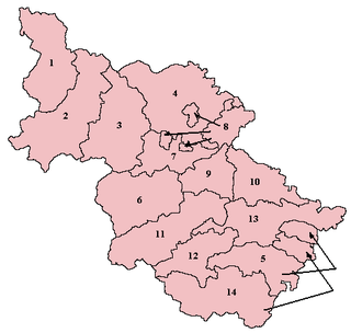
Wapentakes of the West Riding. Barkston Ash is labelled 10 on the map.
Barkston Ash was a wapentake of the West Riding of Yorkshire, named after the meeting-place at the village of Barkston. It included the parishes of Birkin, Bramham cum Oglethorpe, Brayton, Drax, Kirk Fenton, Ledsham, Monk Fryston, Saxton with Scarthingwell and Sherburn-in-Elmet and parts of Brotherton, Kirkby Wharfe, Ryther, Snaith and Tadcaster.
This article is issued from Wikipedia - version of the 9/29/2012. The text is available under the Creative Commons Attribution/Share Alike but additional terms may apply for the media files.