Barmbek
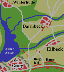
Map, situation in the north-east of Hamburg around 1800
Barmbek, until 27 September 1946 Barmbeck, is the name of a former village that was absorbed into the city of Hamburg, Germany. In 1951 it was divided into the quarters Barmbek-Süd, Barmbek-Nord and Dulsberg in the borough Hamburg-Nord.
History
It was first recorded in 1271 as "Bernebeke". Up until 1946 it was written with a 'c' as Barmbeck. Barmbeck and Barmbek are pronounced with a long e, similar to the English "Barm Bake". The village of Barmbeck had been under Hamburg administration since 1830, and it became a suburb of Hamburg in 1894,[1] while the area of Barmbek-Nord was incoporated into Hamburg in 1937 with the Greater Hamburg Act.[2]
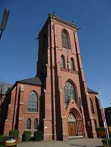
Catholic St. Sophia's Church build 1900
Buildings

House built 1955
near Habichtstraße (Hamburg U-Bahn station)
- Catholic St. Sophia's Church
- Evangelical–Lutheran Bugenhagenkirche[3]
- AK Barmbek clinic
- AK Eilbek clinic[4]
- Museum of work
- Barmbek station[5]
References
- ↑ History of Barmbek, History Workshop Barmbek, in German
- ↑ Barmbek-Nord, Hamburg.de, in German
- ↑ http://www.nordelbien.de/service/kirchentourismus/kirche.bugenhagen/one.info/index.html?entry=page.ges.kirche.bugenhagen[]
- ↑ http://www.schoen-kliniken.com/ptp/kkh/eil/
- ↑ http://www.e-architect.co.uk/hamburg/bahnhof_hamburg_barmbek.htm
External links
| Wikimedia Commons has media related to Barmbek. |
Coordinates: 53°34′58″N 10°02′28″E / 53.58278°N 10.04111°E
This article is issued from Wikipedia - version of the 10/27/2016. The text is available under the Creative Commons Attribution/Share Alike but additional terms may apply for the media files.