Barn Door Hills
| Barn Door Hills | |
|---|---|
 | |
| Highest point | |
| Elevation | c. 560 feet (171 m) and c.. 580 feet (177 m) |
| Coordinates | 41°55′46″N 72°49′31″W / 41.92944°N 72.82528°W and 41°55′57″N 72°49′04″W / 41.93250°N 72.81778°W |
| Geography | |
| Location | Granby, Connecticut |
| Parent range | Metacomet Ridge |
| Geology | |
| Age of rock | 200 million yrs. |
| Mountain type | Fault-block; igneous |
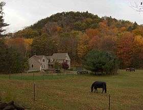
The Barn Door Hills of north-central Connecticut are a pair of prominent rocky trap rock knobs separated by a steep sided gap. They are located in Granby, Connecticut. The hills are an outlying section of the narrow, linear Metacomet Ridge that extends from Long Island Sound near New Haven, north through the Connecticut River Valley of Massachusetts to the Vermont border. The crest of the Metacomet Ridge is located 3.75 miles (6.04 km) east at Hatchet Hill.
Recreation and conservation
East Barndoor Hill is located in the 4,000-acre (16 km2) McLean Game Refuge founded by former United States Senator George P. McLean, and now a National Natural Landmark. A hiking trail summits the hill. West Barndoor Hill is maintained by the Granby Land Trust.[1]
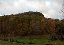
Barndoor Hills from South East
References
- ↑ "Western Barndoor Hill Preserve Trail Map" (PDF). Granby Land Trust. Retrieved 2009-01-11.
- Farnsworth, Elizabeth J. "Metacomet-Mattabesett Trail Natural Resource Assessment." 2004. PDF wefile cited November 1, 2007.
- Connecticut Walk Book: A Trail Guide to the Connecticut Outdoors. 17th Edition. The Connecticut Forest and Park Association. Rockfall, Connecticut. Undated.
- Raymo, Chet and Raymo, Maureen E. Written in Stone: A Geologic History of the Northeastern United States. Globe Pequot, Chester, Connecticut, 1989.
External links
This article is issued from Wikipedia - version of the 7/21/2016. The text is available under the Creative Commons Attribution/Share Alike but additional terms may apply for the media files.