Barre Common District
|
Barre Common District | |
|
Old Town Hall | |
  | |
| Location | Barre, Massachusetts |
|---|---|
| Coordinates | 42°25′20″N 72°6′20″W / 42.42222°N 72.10556°WCoordinates: 42°25′20″N 72°6′20″W / 42.42222°N 72.10556°W |
| Built | 1836 |
| Architect | Elias Carter; Multiple |
| Architectural style | Greek Revival, Other, Romanesque |
| NRHP Reference # | 76000298 [1] |
| Added to NRHP | May 4, 1976 |
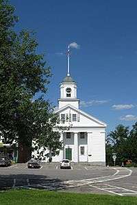
The Barre Common District is a historic district encompassing the town common of Barre, Massachusetts, and immediately adjacent historic buildings. It is bounded roughly by South, Exchange, Main, Pleasant, Broad, School and Grove Streets. The Barre common was laid out in 1792, and has been a focus of the town's civic life ever since. It is flanked by many 19th century buildings, and is the site of memorials to the town's military. The common was used as a militia training ground, and was also the site of the town pound (where stray animals could be coralled). One small section is adorned with a 19th-century horse trough and hay scales.[2]
The district was listed on the National Register of Historic Places in 1976.[1]
See also
References
- 1 2 National Park Service (2008-04-15). "National Register Information System". National Register of Historic Places. National Park Service.
- ↑ "MACRIS inventory record for Barre Common Historic District". Retrieved 2014-02-28.
| Topics |  | ||||||||||||||||||||||||||||||
|---|---|---|---|---|---|---|---|---|---|---|---|---|---|---|---|---|---|---|---|---|---|---|---|---|---|---|---|---|---|---|---|
| Lists by county | |||||||||||||||||||||||||||||||
| Lists by city |
| ||||||||||||||||||||||||||||||
| Other lists | |||||||||||||||||||||||||||||||
| |||||||||||||||||||||||||||||||
This article is issued from Wikipedia - version of the 11/26/2016. The text is available under the Creative Commons Attribution/Share Alike but additional terms may apply for the media files.