Barry Historic District
|
Barry Historic District | |
|
Western side of the public square | |
 | |
| Location | U.S. 36, Barry, Illinois |
|---|---|
| Coordinates | 39°41′41″N 91°2′27″W / 39.69472°N 91.04083°WCoordinates: 39°41′41″N 91°2′27″W / 39.69472°N 91.04083°W |
| Area | 103 acres (42 ha) |
| Built | Various |
| NRHP Reference # | 79000862[1] |
| Added to NRHP | March 13, 1979 |
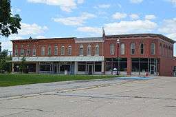
Barry Historic District is a historic district comprising the commercial and older residential areas of Barry, Pike County, Illinois. Barry was founded as an agricultural community in the 1830s, and most of its development took place between its founding and the Civil War. The city's commercial core, however, was mainly built in 1894 after a fire destroyed most of the existing commercial buildings. The 1894 buildings are well-preserved examples of typical commercial architecture of the period, and several have metal storefronts. The district also includes Barry's "Diamond Hill" residential district on Mortimer Street east of Brown Street and several other residential sections. Prominent architectural styles in the residential areas include Italianate, Queen Anne, Carpenter Gothic, and vernacular types from the late 19th century.[2]
The district was added to the National Register of Historic Places on March 13, 1979.[1]
Notes
- 1 2 National Park Service (2010-07-09). "National Register Information System". National Register of Historic Places. National Park Service.
- ↑ Wagner, Robert (April 19, 1978). "National Register of Historic Places Inventory - Nomination Form: Barry Historic District" (PDF). National Park Service. Retrieved November 9, 2014.
Municipalities and communities of Pike County, Illinois, United States | ||
|---|---|---|
| Cities | ||
| Town | ||
| Villages | ||
| Townships | ||
| Unincorporated communities | ||
| Ghost towns | ||
| Topics | |
|---|---|
| Lists by states |
|
| Lists by insular areas | |
| Lists by associated states | |
| Other areas | |
| |