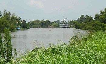
Bayou Lafourche
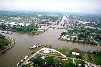
Bayou Lafourche, originally called Chetimachas River[1] or La Fourche des Chetimaches,[2] (the fork of the Chitimacha), is a 106-mile-long (171 km)[3] bayou in southeastern Louisiana, United States, that flows into the Gulf of Mexico. The bayou is between Louisiana Highway 1 on the west, and Louisiana Highway 308 on the east and is known as "the longest Main Street in the world."[4] It flows through parts of Ascension, Assumption, and Lafourche parishes. Today, approximately 300,000 Louisiana residents drink water drawn from the bayou.[5]
History
The name Lafourche is from the French for "the fork",[6] and alludes to the bayou's large outflow of Mississippi River water. The first settlements of Acadians in southern Louisiana were near Bayou Lafourche and Bayou des Écores, which led to a close association of the bayou with Cajun culture.
It was formerly a Mississippi River outlet (distributary), but was dammed at Donaldsonville in 1905.[7] The dam cut off nourishment and replenishment of a huge wetland area of central Louisiana. It changed the formerly flowing bayou into a stagnant ditch.[8]
The Bollinger Shipyards, founded by Donald G. Bollinger, was launched on Bayou Lafourche in 1946.
Mississippi River reintroduction
A project to reconnect Bayou Lafourche to the Mississippi River at Donaldsonville is under design.[9][10] The plan is to use a control structure to regulate the water discharge. The purpose is to mitigate the accelerated land loss that followed the interruption of the distributary flow, and to improve water quality in the bayou.
Crossings
From north to south, the following roads and railroads cross the bayou (almost all connecting LA 1 to LA 308):
- LA 3089 (Albert Street) in Donaldsonville
- Union Pacific Railroad Livonia Subdivision in Donaldsonville
- Rondinaud Road in Donaldsonville
- LA 943
- LA 998 at Belle Rose
- LA 70
- LA 403 at Paincourtville
- LA 70 Spur
- Bridge Street at Plattenville
- LA 402
- former Texas and Pacific Railway (now open to non-motorized traffic)
- LA 1008 at Napoleonville
- LA 1010 at Ingleside
- LA 1011 at Supreme
- LA 1247 at Labadieville
- St. John Bridge
- LA 3185
- Tiger Drive
- former railroad in Thibodaux
- LA 20 (St. Patrick Street) in Thibodaux
- Canal Boulevard in Thibodaux
- Banker Drive (no motor vehicles) in Thibodaux
- Audubon Avenue
- LA 648
- BNSF Railway/Union Pacific Railroad Lafayette Subdivision at Lafourche
- LA 649 (St. Charles Swing Bridge) at St. Charles
- Raceland Lift Span Bridge
- LA 182 (Raceland Lift Bridge) at Raceland
- US 90
- former LA 364
- LA 654 (Champagne-Harrelson Memorial Bridge)
- LA 655 (Rita Bridge) at Lockport
- LA 3220 (Bollinger Bridge)
- Valentine Bridge at Valentine
- T-Bois Bridge
- former LA 310 at Larose
- LA 657 (Larose Pontoon Bridge)
- Le Pont D'or at Cut Off
- Cote Blanche Bridge
- LA 3162 (South Lafourche Bridge)
- Galliano Pontoon Bridge at Galliano
- LA 308 (Golden Meadow Lift Bridge) in Golden Meadow
- LA 1 (Gateway to the Gulf Expressway) at Leeville
In popular culture
The film Southern Comfort is set on Bayou Lafourche.
See also
References
- ↑ "Course Of The River Mississipi, from the Balise to Fort Chartres. Ross, Lieut. 1775" rumsey.geogarage.com
- ↑ Christopher G. Peña (2004). Scarred by War: Civil War in Southeast Louisiana. AuthorHouse. pp. 14–. ISBN 978-1-4184-5544-6.
- ↑ U.S. Geological Survey. National Hydrography Dataset high-resolution flowline data. The National Map Archived 2012-04-05 at WebCite, accessed June 20, 2011
- ↑ Carl A. Brasseaux (2011). Acadiana: Louisiana's Historic Cajun Country. Louisiana State University Press. pp. 105–. ISBN 978-0-8071-3723-9.
- ↑ "Bayou Lafourche Fresh Water District". Retrieved 2014-07-18.
Serving the citizens of Ascension, Assumption, Terrebonne and Lafourche parishes for over 50 years
- ↑ Gannett, Henry (1905). The Origin of Certain Place Names in the United States. Government Printing Office. p. 179.
- ↑ Martin Reuss (2 June 2004). Designing the Bayous: The Control of Water in the Atchafalaya Basin, 1800-1995. Texas A&M University Press. pp. 90–. ISBN 978-1-60344-632-7.
- ↑ Louisiana Department of Culture, Recreation and Tourism. "Bayou Lafourche Historical Marker".
- ↑ "Mississippi River Reintroduction Into Bayou Lafourche (Deauthorized) (BA-25b)". Louisiana Coastal Wetlands Planning Protection and Restoration Act Program. Retrieved 2014-07-18.
- ↑ W.J. Mitsch (23 December 2005). Wetland Creation, Restoration, and Conservation: The State of Science. Newnes. pp. 256–. ISBN 978-0-08-093126-5.