Benneydale
| Bennydale | |
| Country: | New Zealand |
 | |
| Population: | 200 (2014) |
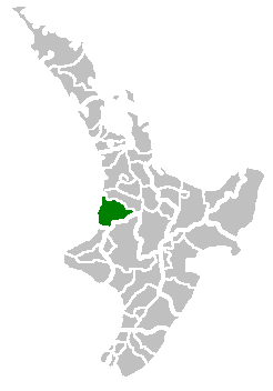
| Rural Area | |
|---|---|
| Extent: | |
| Territorial Authority | |
| Name: | Waitomo District Council |
| Website: | http://www.waitomo.govt.nz/ |
| Mayor: | Brian Hanna |
| Extent: | |
| Land Area: | 3,546.76 km2 (1,369 sq mi) |
| Regional Council | |
| Name: | Environment Waikato |
| Website: | http://www.ew.govt.nz/ |
Coordinates: 38°31′14.06″S 175°21′45.71″E / 38.5205722°S 175.3626972°E
Benneydale is a small town in the Waitomo District. It is situated on State Highway 30 approximately 35 km southeast of Te Kuiti.[1]
After coal was discovered in 1931 a mine was built at the towns present location. In 1940 the government brought the mine and created the township of Benneydale. Its name is a portmanteau of the undersecretary of mines at the time (Mr Benney) and the mine superintendent (Mr Dale). It is the only town in the King Country which does not have a Maori name.[1]
At its peak the town had a population of 2000 with a butchery, bakery and picture theatre.[1][2] There were jobs in the coal mine until the early 1990s, but like many other rural areas in New Zealand the town has slowly declined.[2]
It mainly operates as a farm service town and it is the closest town to the Timber Trail in the Pureora Forest Park. There is also a meat works on the outskirts of town.[1]
Te Miringa te Kakara is the local marae and is located one kilometre outside of town.[1]
Sports broadcaster Keith Quinn was raised in Benneydale.[1]