Bering Canyon
| Bering Canyon | |
|---|---|
|
Bering Sea showing the larger of the submarine canyons that cut the margi | |
| Coordinates | 54°07′59″N 168°15′00″W / 54.133°N 168.25°WCoordinates: 54°07′59″N 168°15′00″W / 54.133°N 168.25°W |
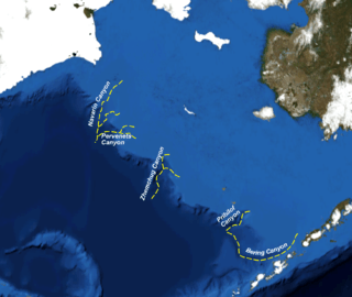
The Bering Canyon is the longest of the Bering Sea submarine canyons; it extends about 400 km across the Bering shelf and slope. It is confined at its eastern edge by the Aleutian Islands. The width of the canyon at the shelf break is about 65 km, only about two-thirds that of the Zhemchug Canyon and Navarin Canyons, but because of its great length, the Bering Canyon has the largest area. At a depth of 3200 m, the Bering Canyon thalweg reaches the Aleutian Basin, where a low-relief submarine channel-lobe system has developed.
References
- Giant submarine canyons at U.S. Geological Survey
This article is issued from Wikipedia - version of the 10/31/2016. The text is available under the Creative Commons Attribution/Share Alike but additional terms may apply for the media files.