Bhakkar District
| Bhakkar بهكّر | |
|---|---|
| District | |
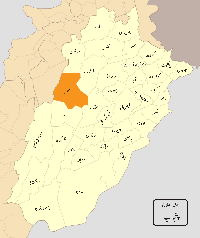 Location of Bhakkar District (highlighted in orange) within Punjab. | |
| Coordinates: 31°37′23″N 71°03′45″E / 31.6230°N 71.0626°ECoordinates: 31°37′23″N 71°03′45″E / 31.6230°N 71.0626°E | |
| Country | Pakistan |
| Province | Punjab |
| Headquarter | Bhakkar |
| Tehsils (4) | |
| Government | |
| • Members of National Assembly |
Abdul Majeed Khan (NA-73) Muhammad Afzal Khan Dhandla (NA-74) |
| Area | |
| • Total | 8,114. km2 (3,133 sq mi) |
| Population (1998)[1] | |
| • Total | 1,051,456 |
| Time zone | PKT (UTC+5) |
| Languages | Thalochi dialect of Punjabi and Urdu |
| Website |
www |
Bhakkar District (Urdu: ضِلع بهكّر), is a district in the province of Punjab, Pakistan. The district was created in 1981 with Bhakkar city as the headquarter and main city. Its area consists of a riverine tract along the Indus, called Kaccha, and most of the district area lies in the desolate plain of the Thal desert.[2]
It is located in the west of the Punjab province, Bhakkar district is bordered by Layyah to its south, Jhang to its south east, Dera Ismail Khan to its west, Khushab to its north east, and Mianwali to its north.
Administration
The district is administratively divided into four Tehsils and 42 Union Councils:[3]
| Name of Tehsil | No of Unions |
|---|---|
| Bhakkar Tehsil | 17 |
| Darya Khan Tehsil | 8 |
| Kaloorkot Tehsil | 10 |
| Mankera Tehsil | 7 |
| Total | 42 |
Khansar Union Council is one of the major Union Councils in Bhakkar. Mari Shah Sakhira Union Council is very close to Bhakkar District boundary
Demography
Bhakkar city has a population of almost 300,000, the total population of the district was estimated to be 1.37 million in 2008. population of the district was 1,391,729 in 2011[1]
Towns
The main towns of District Bhakkar are:
History
Bhakkar region was agricultural region with forests during the Indus Valley Civilization. The Vedic period is characterized by Indo-Aryan culture that invaded from Central Asia and settled in Punjab region. The Kambojas, Daradas, Kaikayas, Madras, Pauravas, Yaudheyas, Malavas and Kurus invaded, settled and ruled ancient Punjab region. After overrunning the Achaemenid Empire in 331 BCE, Alexander marched into present-day Punjab region with an army of 50,000. The Chiniot region was ruled by Maurya Empire, Indo-Greek kingdom, Kushan Empire, Gupta Empire, White Huns, Kushano-Hephthalites and Shahi kingdoms.
In 997 CE, Sultan Mahmud Ghaznavi, took over the Ghaznavid dynasty empire established by his father, Sultan Sebuktegin, In 1005 he conquered the Shahis in Kabul in 1005, and followed it by the conquests of Punjab region. The Delhi Sultanate and later Mughal Empire ruled the region. The Punjab region became predominantly Muslim due to missionary Sufi saints whose dargahs dot the landscape of Punjab region.
The town has some historical places like Dilkusha Bagh which is believed to be a Mughal era garden and is attached to Humayun; but historical facts do not verify it. Humayun never came here. On his retreat to Iran, he went to another Bakhar in Sindh to seek help from Mahmood Khan. But this path or route taken was rejected by Major Henry Raverty as the possible retreat of Humayun.
The old town was walled and had gates as Tavela gate and Imamanwala gate. The only remaining gate Jinnah Gate (formerly King Gate) was built in British period in the name of Mr. King the then Deputy Commissioner. There are remains of a handera (tomb) near Sheikh Raoo bridge, which is believed to be burial place of Bakhar Khan, the founder of the city. The present police station was originally a Baloch fortress. Some 30 years ago a branch of River Indus flowed past the town. West side of the town was green and pleasant.
This is a very scarce silver coin belonging to the reign of Nadir Shah 1148-1160 AH (1735-1747 AD) from the Afsharid dynasty, it is an Indian type minted during his occupation of the area. It is listed by type as Album #2744.2 (Type D). It weighs 11.3 gr. (18 mm.) and minted in the city of Bhakkar in the state of Punjab in India, dated 1157 AH.
After the decline of the Mughal Empire, the Sikh Empire invaded and occupied Bhakkar district. The Muslims faced restrictions during the Sikh rule. The British took over Bhakkar District in 1848.
During British rule, the district was a tehsil of Mianwali District, the population according to the 1891 census of India was 119,219 which had risen to 125,803 at the 1901 census. In addition to the headquarters Bhakkar (population, 5,312), the tehsil contained and 196 villages. The land revenue and cesses amounted in 1903-4 to Rs 1.7 lakhs. Places of interest are Mankera and Muhammad Rajan, at the latter of which is the shrine of Pir Muhammad Rajan, who died there on a pilgrimage.[2]
The predominantly Muslim population supported Muslim League and Pakistan Movement. After the independence of Pakistan in 1947, the minority Hindus and Sikhs migrated to India while the Muslim refugees from India settled in the Bhakkar District.
The main city center is consist of Mandi Town, King gate (markets and shopping centers), Chimni Muhalla (the oldest area in Bhakkar city), Iron Market, Gulshan-e-Madina Town, Officers Colony, Iqbal Town (old name Housing scheme 1) (Farrukh Hasan), Canal Avenue, new developed Green Town, Dhandla Muhalla, Gadola, and Aalam Abad. The adjacent city area Mandi Town is the developed area of the city with entire facilities. The population of city area mostly speak Saraiki, Urdu and Punjabi.The business in the city is major source of income for the population and mostly business activities are connected with capital of Punjab, Lahore.
Independence
The predominantly Muslim population supported Muslim League and Pakistan Movement. After the independence of Pakistan in 1947, the minority Hindus and Sikhs migrated to India while the Muslim refugees from India settled in the Bhakkar District.
Notable people
- Rasheed Akbar Khan Nawani (Politician)
- Saeed Akbar Khan Nawani (Politician)
- Muhammad Sana Ullah Khan Masti Khel (Politician)
- Syed Wazarat Hussain Naqvi (Civil Society Activist)
- Asad Jafri (Educationist and Poet)
References
- 1 2 "Bhakkar District at a Glance". bhakkar.com.pk. Retrieved 22 March 2012.
- 1 2 Bhakkar Tahsil - Imperial Gazetteer of India, v. 8, p. 43
- ↑ Tehsils & Unions in the District of Bhakkar - Government of Pakistan
Provincial capital: Lahore | ||
| Bahawalpur | _Districts.svg.png) | |
| Dera Ghazi Khan | ||
| Faisalabad | ||
| Gujranwala | ||
| Lahore | ||
| Multan | ||
| Rawalpindi | ||
| Sargodha | ||
| Sahiwal | ||
| Sheikhupura | ||
See also: Districts of Punjab, India | ||