Bi-State Vietnam Gold Star Bridges
| The Twin Bridges | |
|---|---|
|
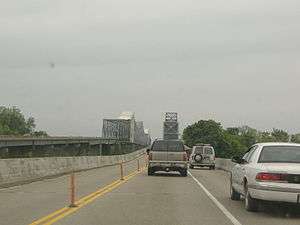
On the northbound bridge; the bridge to the left is the newer southbound bridge, undergoing the 2007–08 renovation. The northbound bridge was reconfigured for two northbound lanes and one southbound lane, leaving one southbound lane on the southbound bridge. | |
| Coordinates | 37°54′15″N 87°33′2″W / 37.90417°N 87.55056°W |
| Carries |
|
| Crosses | Ohio River |
| Locale |
Evansville, Indiana and Henderson, Kentucky |
| Official name | Bi-State Vietnam Gold Star Twin Bridges |
| Maintained by |
KYTC (primary) INDOT (secondary) |
| Characteristics | |
| Design | Paired Cantilever bridges |
The Bi-State Vietnam Gold Star Twin Bridges, usually referred to as simply The Twin Bridges, connect Henderson, Kentucky and Evansville, Indiana along U.S. Route 41 (US 41), one mile (1.6 km) south of the (temporary) southern terminus of Interstate 69 (I-69). The bridges carry nearly 40,000 vehicles a day across the Ohio River. The northbound bridge opened to traffic on July 4, 1932, and the southbound bridge opened on December 16, 1965.[1]
Both of the Bi-State Vietnam Gold Star Bridges are cantilever bridges. The northbound bridge stands 100 feet (30 m) over the Ohio River with a main span of 720 feet (220 m), with the steel gridwork extending 100 feet (30 m) above the driving surface.[2] The southbound span has a main span of 600 feet (180 m).[3]
An unusual fact about the bridges is that they are entirely within Kentucky. Although the Ohio River forms most of the border between Kentucky and Indiana, the state border is based on the course of the river as it existed when Kentucky became a state in 1792. Due to the New Madrid earthquake of 1812, the river changed course to the south, leaving the land where the bridges cross the river within Kentucky.
History
The northbound span of the Bi-State Vietnam Gold Star Bridges was the second of three bridges built in Henderson County in 1932, a building novelty during the Great Depression. It was originally named the John James Audubon Bridge, or Audubon Memorial Bridge, after John James Audubon, who lived in Henderson in the 1810s.[4] It was built by notable bridge designer Ralph Modjeski.[5] The 5,395-foot (1,644 m) long cantilever bridge cost $2.4 million to build, with the federal government paying half, with the states of Kentucky and Indiana paying the remainder.
The dedication ceremony featured Kentucky Governor Ruby Laffoon and Indiana Governor Harry G. Leslie shaking hands with one another, as 22 military planes under the command of Jimmy Doolittle flew overhead with cannon fire and boat whistles in the distance celebrating the occasion.[6] A flotilla of boats passed under the bridge, taking 40 minutes to do so and a two-mile (3.2 km) parade lasting two hours also celebrated the occasion. More than 100,000 visitors attended the celebration and 111,091 vehicles crossed the bridge in its first two days of operation, creating delays of up to two hours to go from Henderson to Evansville.
With the influx of tourists using US 41 to cross the Ohio River, the city of Henderson decided to take advantage of the bridge by establishing John James Audubon State Park in 1936. Originally, crossing the bridge required paying a toll, usually 30 to 35 cents for cars, and a nickel for pedestrians. The toll was removed on March 20, 1941.[3][5][7]
Renovations
In 2007, the Bi-State Vietnam Gold Star Bridges underwent $22 million in renovations involving maintenance and painting. Kentucky Governor Ernie Fletcher directed that at least two lanes in each direction should remain open during the construction. The maintenance ended in the middle of 2008.[8] The last time the northbound bridge was rehabbed was in 1983.[6]
After the I-35W Mississippi River bridge collapsed in Minneapolis, Minnesota, in August 2007, officials stated that the main threat to the safety of the Bi-State Vietnam Gold Star Bridges would be a "catastrophic earthquake". This statement was made before the 2008 Illinois earthquake. After the 5.2 earthquake hit, Kentucky Transportation Cabinet spokesman Keith Todd said that such a quake "would not be expected to cause damage to well-engineered structures." However, both bridges were inspected as a precaution.[9][10]
The bridges are located at 37°54'15" N, 87°33'02" W. Although they are not currently on the list, they have been ruled eligible for inclusion in the National Register of Historic Places.[11]
References
| Wikimedia Commons has media related to Twin Bridges (Evansville). |
- ↑ "Bevin speech makes advocates more hopeful than ever for I-69 bridge". Evansville Courier & Press. February 13, 2016. Retrieved February 13, 2016.
- ↑ "Notable Bridges in North America". A&E Television Networks. Archived from the original on October 16, 2007. Retrieved March 25, 2007.
- 1 2 "Bridge Building Boom Henderson County KY". HendersonKYHistory.com. Archived from the original on April 30, 2011. Retrieved April 26, 2011.
- ↑ "History of John James Audubon State Park". Commonwealth of Kentucky. Retrieved February 26, 2011.
- 1 2 "Northbound bridge celebrating 75 years". Local News. Evansville Courier Press. July 1, 2007. Archived from the original on June 6, 2011. Retrieved April 26, 2011.
- 1 2 "Transportation Officials Formulate Plan to Maintain Traffic Flow on US 41 Twin Bridges in Henderson". Commonwealth of Kentucky. Archived from the original on January 9, 2009. Retrieved January 20, 2009.
- ↑ "Henderson County, Kentucky Genealogical Records Information". genealogyinc.com. Retrieved April 26, 2011.
- ↑ "Konnection Employee Newsletter" (PDF). Kentucky Transportation Cabinet. Retrieved January 20, 2009.
- ↑ Martin, John (August 3, 2007). "Officials say twin bridges safe". Local News. Evansville Courier Press. Archived from the original on June 6, 2011. Retrieved April 26, 2011.
- ↑ "No major damage evident here from earthquake". News. Evansville Courier Press. April 18, 2008. Archived from the original on June 6, 2011. Retrieved April 26, 2011.
- ↑ "Historic Bridges of the U.S.: Evansville Bridge". 37.904167;-87.550556: Bridgehunter.com. Archived from the original on May 23, 2011. Retrieved April 26, 2011.
| Bridges of the Ohio River | ||||
|---|---|---|---|---|
| ||||
Coordinates: 37°54′15″N 87°33′2″W / 37.90417°N 87.55056°W