Bingham Wapentake
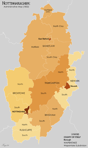
Bingham was a wapentake (equivalent to a hundred) of the historic county of Nottinghamshire, England. It was in the south east of the county, to the south of the River Trent, covering the parishes of Adbolton, Aslockton, Bingham, Car Colston, Clipston on the Wolds, Colston Bassett, Cotgrave, Cropwell Bishop, Cropwell Butler, East Bridgford, Elton, Flintham, Gamston, Granby, Hawksworth, Hickling, Holme Pierrepont, Kinoulton, Kneeton, Langar cum Barnstone, Lodge on the Wolds, Normanton-on-the-Wolds, Orston, Owthorpe, Plumtree, Radcliffe on Trent, Saxondale, Scarrington, Screveton, Shelford, Thoroton, Tithby, Tollerton, Upper Broughton, West Bridgford, Whatton and Wiverton Hall.
Contained within the boundaries of the wapentake are the eastern parts of the current Rushcliffe Borough.
The original meeting place of the wapentake was on the Toot Hill ridge, west of Bingham.[1]
References
- ↑ Valerie Henstock, Structural Nottinghamshire Heritage Gateway: Bingham
| Unitary authorities | |
|---|---|
| Boroughs or districts | |
| Major settlements | |
| Topics | |