Black Buttes
| Black Buttes | |
|---|---|
|
The eroded Black Buttes are the rocky peaks on the right. The young stratocone of Mount Baker is on the left | |
| Highest point | |
| Peak | Colfax Peak |
| Elevation | 9,373 ft (2,857 m) [1] |
| Coordinates | 48°46′16″N 121°50′39″W / 48.7712308°N 121.8440353°WCoordinates: 48°46′16″N 121°50′39″W / 48.7712308°N 121.8440353°W [1] |
| Geography | |
 Black Buttes Whatcom County, Washington, United States | |
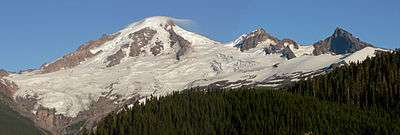
Black Buttes is an extinct volcano in the Cascade Volcanic Arc in Washington, United States. Glacially eroded remnants of this volcano rise above the Deming Glacier, part of the glacier system of Mount Baker.[2]
The volcano was last active between 500,000 and 300,000 years ago.[3] Mount Baker, a much younger volcano, sits on top of lava erupted from Black Buttes Volcano. Mount Baker volcano is less than 140,000 years old.[3]
References
- 1 2 "Colfax Peak". Geographic Names Information System. United States Geological Survey. Retrieved 2015-08-18.
- ↑ "Black Buttes". Geographic Names Information System. United States Geological Survey. Retrieved 2015-08-18.
- 1 2 Hildreth, W.; Fierstein, J; Lanphere, M. (2003). "Eruptive history and geochronology of the Mount Baker volcanic field, Washington". Geol. Soc. Am. Bull. 115 (6): 729–764. doi:10.1130/0016-7606(2003)115<0729:EHAGOT>2.0.CO;2.
This article is issued from Wikipedia - version of the 11/26/2016. The text is available under the Creative Commons Attribution/Share Alike but additional terms may apply for the media files.