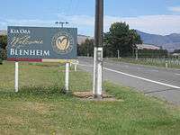
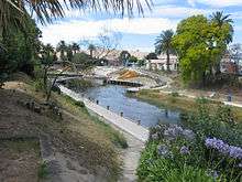
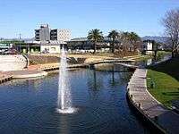
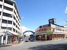
Blenheim, New Zealand
| Blenheim Waiharakeke (Māori) | |
|---|---|
| Main urban area | |
|
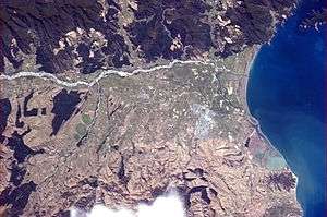
Blenheim pictured from the International Space Station | |
 Blenheim | |
| Coordinates: 41°30′50″S 173°57′36″E / 41.514°S 173.960°ECoordinates: 41°30′50″S 173°57′36″E / 41.514°S 173.960°E | |
| Country |
|
| Region | Marlborough |
| Territorial authority | Marlborough District |
| Named for | Battle of Blenheim |
| Member of Parliament | Stuart Smith, Kaikoura Electorate |
| Suburbs |
List
|
| Government | |
| • Mayor | John Leggett |
| Area | |
| • Total | 103.89 km2 (40.11 sq mi) |
| Population (June 2016)[1] | |
| • Total | 30,700 |
| • Density | 300/km2 (770/sq mi) |
| Postcode | 7201 |
| Area code(s) | 03 |
Blenheim (/ˈblɛnɪm/; Māori: Waiharakeke) is the most populous town in the region of Marlborough, in the north east of the South Island of New Zealand. It has an urban population of 30,700 (June 2016).[1] The surrounding area is well known as a centre of New Zealand's wine industry. It enjoys one of New Zealand's sunniest climates, with hot, relatively dry summers and crisp winters.
The Marlborough Region in which Blenheim is situated has a wide range of leisure activities, from swimming with dolphins in the Marlborough Sounds to watching whales in Kaikoura; from walks through the bush and along the rugged coastline, and scenic boat cruising, fishing, water-skiing and kayaking. The relaxed lifestyle and the flourishing wine and gourmet food industry in Marlborough are enjoyed by both locals and visitors alike.
Blenheim is named after the Battle of Blenheim (1704), where troops led by John Churchill, 1st Duke of Marlborough defeated a combined French and Bavarian force.
History
The sheltered coastal bays of Marlborough supported a small Māori population possibly as early as the 12th century. Māori in the Marlborough Region cultivated crops, including kumara (sweet potato) and exploited marine resources.
Although the early history of Marlborough was closely associated with the Nelson settlement, the people of Marlborough wanted independence from Nelson. Nineteen years after the original Nelson settlement the request of Marlborough settlers was granted, and Marlborough became a separate province in 1859. Although gold was discovered in the province in the early 1860s the boom did not last and, while it helped to expand the region, the development of pastoralism provided the greatest long-term benefits. Marlborough squatters developed huge sheep runs that dominated the countryside, rivalling Canterbury's sheep stations in size and wealth.
Geography
On the Wairau Plain, the town is mostly flat with surrounding hills, which do not give as much protection from prevailing winds as might be expected. Open areas in and around Blenheim are hit quite hard by winds blowing from Cook Strait. Blenheim sits at the confluence of the Taylor and Ōpaoa rivers. It is in a tectonically active zone and experiences several (usually small) earthquakes each year. The boundary between the Pacific plate (on which Blenheim sits) and the Indo-Australian plate passes just north of Blenheim.
Climate
The climate is generally very settled, largely due to the rainshadow effect of the mountain ranges to the west which shelter Blenheim from the heaviest of rains that hit the western part of the South Island.
Summers are typically warm and dry while winters are normally cool and frosty with clear sunny days that follow. Snowfall is rare as it is sheltered from cold southerly weather by the mountain ranges to the south.
Thunderstorms are an uncommon occurrence due to the sheltered climate. There is a higher likelihood in summer, when afternoon heating can generate a buildup of clouds above the ranges.
The highest recorded temperature is 37.8C, Recorded on 23 February 1973.[2] The lowest is −8.8C.
| Climate data for Blenheim (1981–2010) | |||||||||||||
|---|---|---|---|---|---|---|---|---|---|---|---|---|---|
| Month | Jan | Feb | Mar | Apr | May | Jun | Jul | Aug | Sep | Oct | Nov | Dec | Year |
| Average high °C (°F) | 24.1 (75.4) |
23.8 (74.8) |
21.9 (71.4) |
19.0 (66.2) |
16.0 (60.8) |
13.3 (55.9) |
12.6 (54.7) |
13.8 (56.8) |
15.8 (60.4) |
18.0 (64.4) |
20.0 (68) |
22.2 (72) |
18.4 (65.1) |
| Daily mean °C (°F) | 18.0 (64.4) |
17.6 (63.7) |
15.8 (60.4) |
13.0 (55.4) |
10.2 (50.4) |
7.7 (45.9) |
7.0 (44.6) |
8.2 (46.8) |
10.3 (50.5) |
12.2 (54) |
14.2 (57.6) |
16.5 (61.7) |
12.6 (54.7) |
| Average low °C (°F) | 11.8 (53.2) |
11.5 (52.7) |
9.8 (49.6) |
6.9 (44.4) |
4.5 (40.1) |
2.2 (36) |
1.5 (34.7) |
2.6 (36.7) |
4.7 (40.5) |
6.5 (43.7) |
8.4 (47.1) |
10.8 (51.4) |
6.8 (44.2) |
| Average precipitation mm (inches) | 48.9 (1.925) |
49.4 (1.945) |
46.5 (1.831) |
52.7 (2.075) |
60.6 (2.386) |
70.7 (2.783) |
74.3 (2.925) |
62.2 (2.449) |
65.2 (2.567) |
67.4 (2.654) |
55.0 (2.165) |
58.1 (2.287) |
711.0 (27.992) |
| Average precipitation days (≥ 1.0 mm) | 5.0 | 5.1 | 5.5 | 5.3 | 6.7 | 7.9 | 7.6 | 8.0 | 8.5 | 8.3 | 6.9 | 6.7 | 81.5 |
| Average relative humidity (%) | 68.7 | 74.2 | 74.9 | 77.5 | 81.5 | 82.3 | 83.7 | 80.8 | 73.3 | 72.1 | 67.7 | 67.5 | 75.4 |
| Mean monthly sunshine hours | 262.2 | 223.7 | 230.8 | 193.7 | 172.7 | 151.6 | 157.1 | 183.9 | 189.5 | 226.7 | 234.7 | 248.8 | 2,475.3 |
| Source: NIWA Climate Data[3] | |||||||||||||
Demographics
| Historical population | ||
|---|---|---|
| Year | Pop. | ±% p.a. |
| 1996 | 26,100 | — |
| 2001 | 27,300 | +0.90% |
| 2006 | 29,100 | +1.29% |
| 2013 | 30,100 | +0.48% |
| Source: [1] | ||
At the 2006 census, Blenheim had a population of 28,700, a change of 7.0% since the 2001 census. The June 2016 estimate puts Blenheim's population at 30,700.[1] Following the 2013 census, Blenheim became the country's 17th main urban area, after Statistics New Zealand promoted the town from a secondary urban area.
Age
- 21.3% of people were under 15, compared with 22.7% for New Zealand.
- 16.7% of people were 65 and over, compared with 12.1% for New Zealand.
Education
- 28.7% of people 15 and over had a post-secondary-school qualification, compared with 32% for New Zealand.
Ethnic background
Most residents are of European origin, predominantly of British, Irish, German and Dutch descent. Small Māori, Pacific Island and Asian communities exist. Ethnic diversity has increased in recent years with the arrival of large numbers of South Americans (mostly Brazilians) and Asians (mainly Indonesian, Japanese, Korean and Filipino), who work in the expanding viticulture sector.
The 2006 New Zealand Census found that of people in the Blenheim Urban Area who completed the census forms:
- 78.4% belonged to the European or Pākehā ethnic group
- 1.6% belonged to the Asian ethnic group
- 10.5% belonged to the Māori ethnic group
- 1.6% belonged to the Pacific Island ethnic group
- 0.5% belonged to the Middle Eastern/Latin American/African ethnic groups
- 16.1% belonged to Other ethnic group
Suburbs
- Blenheim
- Grovetown
- Mayfield
- Omaka
- Redwoodtown
- Renwick
- Riverlands
- Riversdale
- Spring Creek
- Springlands
- Witherlea
- Wither Hills
- Woodbourne
- Yelverton
Economy
The region's economy is rurally based with pastoral and horticultural farming providing a major source of income. The inhabitants continue to use the marine resources. Lake Grassmere is the country's only source of salt. Fishing and mussel farming are also extremely important in the region. Grape growing has been one of the fastest growing industries and Marlborough is now New Zealand's largest wine producing region, receiving worldwide recognition for its sauvignon blanc wines. Olive growing has also become popular in recent years.
The Marlborough region is famous for its wine production, although other forms of agriculture are significant and the services sectors is also important.
With the growing international critical recognition of Marlborough Sauvignon blanc, much of the wine industry has come to be dominated by large firms, owned by major New Zealand companies or offshore investors. There are over 50 vineyards near Blenheim. Agricultural land prices in the Wairau Valley increased dramatically in the 1990s and 2000s.
Lifestyle
The sunny, pleasant climate has long attracted people to the region, as holiday-makers or as permanent settlers. The region is especially popular among retired people, as well as people seeking an alternative lifestyle. Rapid population growth and other factors though have led to a contemporary chronic shortage of affordable housing for low and middle income earners.
Education
The first school opened in 1859. By 1875 there were three classes: Blenheim Upper Boys', Blenheim Lower Boys', and Blenheim Girls' and Infants'. Blenheim High School was formed within the school in 1879.[4]
Catholic schools for boys and girls were established in 1872, replaced by St Mary's Boys' school in 1886. In 1929 St Mary's was rebuilt after a fire.[5]
Marlborough High School, a coeducational secondary school, was founded in Blenheim in 1900. It moved to the Marlborough Boys' College Stephenson Street site in 1901. In 1919 it changed its name to Marlborough College. The intermediate section was split to form Bohally Intermediate in 1956, and the girls moved to form Marlborough Girls' College in 1962, when the school took its current name.[6]
Marlborough Boys' College is a boys' secondary (years 9–13) school with a roll of 1006.[7] Marlborough Girls' College is a girls' secondary (years 9–13) school with a roll of 1029.[8] Both have a decile rating of 7.
The other schools are all coeducational.
Bohally Intermediate is an intermediate (years 7–8) school with a roll of 407 and a decile rating of 6.[9]
Blenheim School and Whitney Street School are contributing primary (years 1–6) schools with decile ratings of 3 and 5 respectively. Blenheim School has a roll of 81, Whitney Street School 248.[10][11]
St Mary's School is a state integrated full primary (years 1–8) school with a decile rating of 8 and a roll of 376.[12]
Other primary schools are in Redwoodtown, Witherlea, Mayfield, and Springlands, and in the surrounding localities of Renwick, Fairhall, Grovetown, Rapaura and Riverlands.
The Nelson Marlborough Institute of Technology has a campus in Blenheim.[13]
Transportation
Air
Woodbourne Airport is a domestic airport and an RNZAF operational base. There are direct flights from Auckland and Wellington with Air New Zealand, from Nelson and the Kapiti Coast with Air2there and from Wellington, Napier, Christchurch and Paraparaumu with Sounds Air.[14]
Omaka Aerodrome, to the south of the town centre, is used solely by private and vintage aircraft. An airshow (based mainly on World War I and II aircraft) is held biennially at Easter.
Road
State Highway 1 runs through Blenheim and State Highway 6 terminates at the junction of the two state highways. Blenheim is notable for a town of its size in that it does not have traffic lights at any intersection.[15] Instead, roundabouts speed arterial traffic flow. Since the installation of roundabouts traffic volumes have quickly increased and upgrading options are being considered, e.g. traffic lights, longer two-lane approaches and even a bypass.[16]
Rail
Blenheim is on the Main North Line, the northern part of the unofficially-named South Island Main Trunk Railway. The Coastal Pacific, the daily summer-only long-distance passenger train between Picton and Christchurch, stops at Blenheim Railway Station. The 1906 station has been listed NZHPT Category II since 1982.[17] It is a standard Vintage station, with Tudor half-timbering and tile.[18]
A major rail freight facility is north of Blenheim at Spring Creek.
The narrow-gauge Blenheim Riverside Railway runs through the town.
Media
Blenheim is served by a variety of print publications. The major daily newspaper serving the area is The Marlborough Express published by Fairfax NZ, with its headquarters in Blenheim. The Saturday Express and Midweek are community newspapers published by the same company and distributed throughout Marlborough. The Blenheim Sun is a twice-weekly free newspaper distributed each Wednesday and Friday.
- Radio
This is a list of FM radio stations in Blenheim. The town can also receive most AM and FM radio stations from Wellington, across Cook Strait; these are not included.
| FM Frequency | Nickname | Callsign | Format |
|---|---|---|---|
| 87.6 | Sunshine Radio | Easy Listening | |
| 88.0 | World FM | International/News | |
| 88.9 | Fresh FM Nelson | Alternative Community Radio | |
| 89.7 | The Breeze | Easy Listening (formerly known as Easy FM) | |
| 90.5 | ZM | Top 40 | |
| 91.3 | The Rock | Modern Rock | |
| 92.1 | Newstalk ZB | News/Talk | |
| 92.9 | MORE FM Marlborough | Adult Contemporary (formerly known as Sounds FM) | |
| 93.7 | Life FM | Christian/Alternative | |
| 94.5 | Radio Hauraki | Modern/Alternative Rock | |
| 95.3 | Radio Live | News/Talk | |
| 96.1 | The Sound | Classic Rock | |
| 96.9 | The Hits Marlborough | 2ZZE-FM | The Hits (formerly known as Radio Marlborough) |
| 98.5 | Radio Sport | Sports/Talk | |
| 99.3 | Radio New Zealand Concert | Classical | |
| 100.9 | Brian FM | Variety Hits | |
| 101.7 | Radio New Zealand National | Public Radio | |
| 104.1 | Rhema | Christian Music & Talk | |
| 104.9 | The Edge FM | Top 40 | |
| 105.7 | Magic | 60s | |
| 106.7 | Whisper FM | Nostalgia | |
Events and points of interest
Omaka Aerodrome, south of the town centre, is the setting for the two-yearly Classic Fighters Marlborough airshow. With a large emphasis on aircraft of World War One, it has been held since 2001.
The Forrest Graperide is a 101 km (63 mi) cycle race through the most picturesque scenery in Marlborough every autumn and is a big drawcard for cyclists from all over New Zealand.
Hunters Garden Marlborough is an annual event held over a few days in early November that celebrates the gardens and the love of gardening in Marlborough. The event comprises garden tours, specialist workshops, and a fete.[19]
The Havelock Mussel festival is an annual event held in mid March that celebrates the mussel industry.
Kaikoura Seafest is held annually in late September/early October, celebrating the food, wines, and beverages from the Kaikoura, Marlborough and North Canterbury regions.
The first weekend in February sees the festival "Blues, Brews and BBQ's", which comprises Blues and Jazz music, food and beer and wine.
The second weekend in February marks the annual event of Wine Marlborough, a showcase of the regions wines at Brancott Estate vineyard with good food and great entertainment.
The Marlborough Wine Weekend, first held in 2007 and held biannually since in late October, is a showcase of new release Marlborough wines and the wine-growing region. Hosted at stunning sites, it is a wine enthusiast's Mecca and a quality destination event with trade and VIP guests enjoying fine wine, gourmet cuisine and venues.
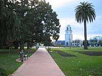
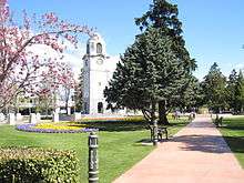
Seymour Square and Pollard Park are two of the town's main attractions for walks and general tourism. Seymour Square is an open public area in the centre, containing the War Memorial and Clock Tower, unveiled in 1928, classified as a "Category I" ("places of 'special or outstanding historical or cultural heritage significance or value'") historic place by the New Zealand Historic Places Trust.[20] The Square was named after Henry Seymour.[21]
The Wither Hills just out of Blenheim have many attractive walks just off Maxwell Road. They are dry and arid and have seen many severe forest fires.
The GCSB Waihopai communications monitoring facility, part of the ECHELON network, is near Blenheim.
References
- Bibliography
- Reed, A. W. (2002). The Reed Dictionary of New Zealand Place Names. Auckland: Reed Books. ISBN 0-7900-0761-4.
- Notes
- 1 2 3 4 "Subnational Population Estimates: At 30 June 2016 (provisional)". Statistics New Zealand. 21 October 2016. Retrieved 21 October 2016. For urban areas, "Subnational population estimates (UA, AU), by age and sex, at 30 June 1996, 2001, 2006-16 (2017 boundary)". Statistics New Zealand. 21 October 2016. Retrieved 21 October 2016.
- ↑ http://cliflo.niwa.co.nz
- ↑ "Climate Data and Activities". NIWA. Retrieved 19 October 2013.
- ↑ A. D. McIntosh, ed. (1940). Marlborough – A Provincial History. pp. 338–349.
- ↑ A. D. McIntosh, pp 328–329
- ↑ "Marlborough Boys' College – History".
- ↑ "Te Kete Ipurangi – Marlborough Boys' College". Ministry of Education.
- ↑ "Te Kete Ipurangi – Marlborough Girls' College". Ministry of Education.
- ↑ "Te Kete Ipurangi – Bohally Intermediate". Ministry of Education.
- ↑ "Te Kete Ipurangi – Blenheim School". Ministry of Education.
- ↑ "Te Kete Ipurangi – Whitney Street School". Ministry of Education.
- ↑ "Te Kete Ipurangi – St Mary's School, Blenheim". Ministry of Education.
- ↑ "Marlborough Campus". Nelson Marlborough Institute of Technology.
- ↑ "Sounds Air - Routes". Retrieved 26 September 2016.
- ↑ Maria Slade (20 January 2016). "New Zealand's biggest town without traffic lights: Blenheim". Stuff.co.nz. Retrieved 28 May 2016.
- ↑ Selina Powell (25 May 2016). "New Zealand Transport Agency investigates State Highway 1 between Picton and Christchurch". Stuff.co.nz.
- ↑ NZHPT listing with photo
- ↑ Rail Heritage Trust – Blenheim
- ↑ "Hunter's Garden Marlborough, Garden Tours, Workshops, Market Day.". Retrieved 24 January 2012.
- ↑ "War Memorial and Clock Tower". Register of Historic Places. Heritage New Zealand. Retrieved 2009-12-21.
- ↑ An Encyclopaedia of New Zealand 1966
External links
| Wikimedia Commons has media related to Blenheim, New Zealand. |
| Wikivoyage has a travel guide for Blenheim. |