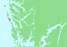
Blomøyna
 Location in Hordaland county | |
| Geography | |
|---|---|
| Location | Hordaland, Norway |
| Coordinates | 60°32′25″N 4°53′18″E / 60.5402°N 4.8883°ECoordinates: 60°32′25″N 4°53′18″E / 60.5402°N 4.8883°E |
| Area | 9.1 km2 (3.5 sq mi) |
| Length | 5 km (3.1 mi) |
| Width | 3.5 km (2.17 mi) |
| Highest elevation | 74 m (243 ft) |
| Highest point | Blomøyknuten |
| Administration | |
| County | Hordaland |
| Municipality | Øygarden |
Blomøyna or Blomøy is an island in Øygarden municipality in Hordaland county, Norway. The 9.1-square-kilometre (3.5 sq mi) island is the second largest island in the municipality. The island lies north of the island of Rongøyna and south of the island of Ona. The southern part of the island is split into two parts by the Blomvågen fjord which cuts northward for 2 kilometres (1.2 mi) into the island. The village of Blomvåg surrounds the inner part of the Blomvågen fjord. Nearly all of the island's residents live in Blomvåg. Blomvåg Church is located in the village, serving the whole southern part of the municipality.[1]
See also
References
- ↑ Store norske leksikon. "Blomøy" (in Norwegian). Retrieved 2014-11-24.
This article is issued from Wikipedia - version of the 11/11/2016. The text is available under the Creative Commons Attribution/Share Alike but additional terms may apply for the media files.