Bloomsburg Municipal Airport
| Bloomsburg Municipal Airport | |||||||||||
|---|---|---|---|---|---|---|---|---|---|---|---|
| IATA: none – ICAO: none – FAA LID: N13 | |||||||||||
| Summary | |||||||||||
| Airport type | Public | ||||||||||
| Owner | Town Of Bloomsburg | ||||||||||
| Location | Bloomsburg, Pennsylvania | ||||||||||
| Elevation AMSL | 481 ft / 147 m | ||||||||||
| Coordinates | 40°59′52″N 76°26′10″W / 40.9977°N 76.4360°WCoordinates: 40°59′52″N 76°26′10″W / 40.9977°N 76.4360°W | ||||||||||
| Runways | |||||||||||
| |||||||||||
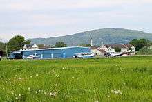
Airplanes at the Bloomsburg Municipal Airport from Airport Road
Bloomsburg Municipal Airport (FAA LID: N13) is a public non-towered general aviation airport along the Susquehanna River within town limits on the south east corner of Bloomsburg.
Services: Columbia Aircraft Services, Inc.
Fuel: 100LL
Clubs: Parlor City Flying Club
External links
- Resources for this airport:
- FAA airport information for N13
- AirNav airport information for N13
- FlightAware airport information and live flight tracker
- SkyVector aeronautical chart for N13
References
- Bloomsburg Municipal Airport (official web site)
This article is issued from Wikipedia - version of the 11/4/2016. The text is available under the Creative Commons Attribution/Share Alike but additional terms may apply for the media files.