Blue Water Bridge
| Blue Water Bridge | |
|---|---|
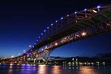 Blue Water Bridge, newer bridge in foreground | |
| Coordinates | 42°59′55″N 82°25′25″W / 42.99869°N 82.42351°WCoordinates: 42°59′55″N 82°25′25″W / 42.99869°N 82.42351°W |
| Carries |
6 lanes of |
| Crosses | St. Clair River |
| Locale | Port Huron, Michigan and Point Edward, Ontario |
| Official name | Blue Water Bridge |
| Maintained by | MDOT and Federal Bridge Corporation |
| Characteristics | |
| Design |
Cantilever truss (westbound) Continuous tied arch (eastbound) |
| Total length |
6,178 feet (1,883 m) (westbound) 6,109 feet (1,862 m) (eastbound) |
| Width |
38 feet (12 m) (westbound) 51 feet (16 m) (eastbound) |
| Height |
210 feet (64 m) (westbound) 233 feet (71 m) (eastbound) |
| Longest span |
871 feet (265 m) (westbound) 922 feet (281 m) (eastbound) |
| Clearance below |
152 feet (46 m) (westbound) 155 feet (47 m) (eastbound) |
| History | |
| Opened |
October 10, 1938 (westbound) July 22, 1997 (eastbound) |
| Statistics | |
| Daily traffic |
|
| Toll |
Cars: $3.00 USD or $4.00 CAD (to Canada) and $3.50 USD or $4.00 CAD (to US) as of April 22, 2016. Extra Axles: $4.00 CAD or $3.50 USD. Trucks & Buses: $4.25 CAD or $3.75 USD Per Axle (to US) and $3.25 USD or $4.50 CAD Per Axle (to Canada) |
.jpg)
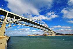
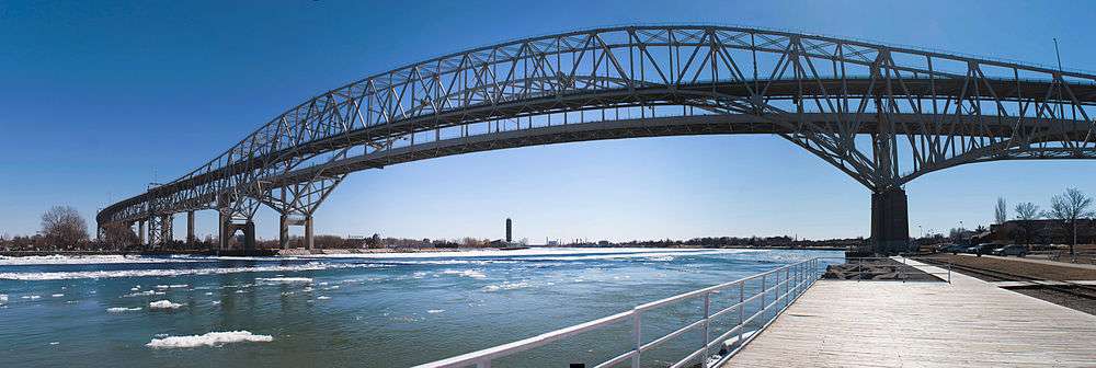
The Blue Water Bridge is a twin-span international bridge across the St. Clair River that links Port Huron, Michigan, United States, and Point Edward, Ontario, Canada. The Blue Water Bridge connects Highway 402 in Ontario with both Interstate 69 (I-69) and Interstate 94 (I-94) in Michigan.
The original span is a cantilever truss bridge with a total length of 6,178 feet (1,883 m) and a main span of 871 feet (265 m). The second, newer span is a continuous tied-arch bridge with a total length of 6,109 feet (1,862 m) and a main span of 922 feet (281 m).
Together, the two bridges are the second-busiest crossing between the United States and Canada, after the Ambassador Bridge at Detroit-Windsor. They are the fourth-busiest international crossing in Ontario in terms of total number of vehicles.[2] Overall, in Canada, they are the third-busiest bridges after the Champlain Bridge, in Montreal, and the Ambassador Bridge. They also provide one of the four shortest routes of land travel between the Northeastern United States (particularly New England) and the central United States. The Blue Water Bridges are jointly owned and maintained by Canada and the United States: Federal Bridge Corporation, a Crown corporation of the Government of Canada, is in charge of the Canadian side,[3] and the Michigan Department of Transportation (MDOT) is in charge of the U.S. side.[4] A toll is charged to cross the bridges, which is used to pay for maintenance and operations.
History
The first bridge was fully opened to traffic on October 10, 1938.[5] The lead engineer was Polish-born Ralph Modjeski. This bridge originally had two lanes for vehicles as well as sidewalks; the latter were removed in the 1980s to make room for a third lane for automobiles. The third lane for each direction started from the apex of the bridge in order to accommodate long lineups entering each sides' respective border crossings.
In 1928, Maynard D. Smith hired a Pennsylvania-based company named Modjeski and Masters to build what would become the Blue Water Bridge. Ralph Modjeski, a Polish-born engineer who would become known as "America's greatest bridge builder", served as lead engineer for the project. In developing a design, Modjeski faced obstacles posed by the U.S. Army Corps of Engineers, which sought to ensure that the St. Clair River remain navigable for military and commercial vessels. Bridge construction could not interfere with navigation, bridge builders could not use floating platforms, and the completed span was required to clear the water by 150 ft. Originally, Modjeski proposed a mammoth suspension-style bridge with tall towers and massive cable anchorages; however, because of the 150-ft. vertical clearance requirement for shipping, he opted instead for a cantilevered through-truss design.
In 1935, the Michigan Legislature passed a law (Act 147, Public Acts of 1935) creating a State Bridge Commission to finance the design and erection of the main bridge structure of the Blue Water Bridge. The commission was approved by the United States Congress in August 1935 (Public Law 411 of 1935). The law permitted the commission to sell bonds ($.25 toll for travelers) that would be repaid by the revenue from the tolls collected within 30 years.
When the bridge and its associated bonds were paid off, Michigan Governor John Swainson used an executive order to cancel the $.25 toll that had been collected. "Stoically", he effectively cancelled his own father's "$6,115-a-year toll-collector's job", which John A. C. Swainson held since 1957.[6]
In 1964, the eastern terminus of I-94 was completed at the foot of the Blue Water Bridge on the American side.[7] Traffic volumes steadily increased, spurred by the completion of Highway 402 in 1982 which provided a continuous freeway link to Highway 401 on the Canadian side. In 1984, I-69 was completed to Port Huron which meant that three freeways converged on the three-lane bridge.[7]
As a precursor to the upcoming twinning project, the customs and toll collection booths on both sides were extensively reconfigured in the early 1990s. On the American side, the I-beam girder overpass crossing Pine Grove Avenue was replaced by a much wider embankment, which also added a four-story customs office building in the center. On the Canadian side this necessitated the demolition of the original booths that had been in use since 1938; these were noted for their Art Deco style but they were too low to accommodate semi-trailer trucks which had been directed to the outside.
In 1992, it was determined that traffic on the bridge had exceeded its rated capacity,[8][9] so bridge authorities decided to add a second span in order to accommodate the high traffic. During the debate over the form of the second span, five possible designs were proposed from 1994–1995. Over half of public opinion had mostly favored a duplicate of the first bridge, while the cable-stayed bridge came in second with around 21%. The Blue Water Bridge Authority had rejected both designs, due to the duplicate creating a false sense of history, while the cable-stayed option was feared to overshadow the existing bridge. Another cost-effective but unpopular design was the parallel truss. The continuous-tied arch design, which was a distant third place in polls, was chosen for two reasons. One was that it blends in with the original span yet stands out on its own, and the other is lower maintenance costs because fewer spans are involved.
The twinning project was a combined effort between Modjeski & Masters (American engineers) and Buckland & Taylor Ltd. (Canadian engineers). During the construction, two temporary masts were erected to assist in the construction of the tied arch; the towers were painted red and lighted, enabling them to be seen from afar.[10] The approaches to the new bridge use box girders, compared to the original which hold up the road deck with trusses.[11]
The second three-lane bridge, just south of the first bridge, opened on July 22, 1997. The first bridge was immediately closed for extensive renovation. During this period, the new span used a three-lane configuration reminiscent of the one employed on the original bridge. A flyover ramp on the U.S. side temporarily diverted westbound traffic from the new bridge to the toll plaza, which was blocked off after the original bridge was rehabilitated.[12] The original span was reopened on November 13, 1999, making the Blue Water Bridge the largest infrastructure-crossing project in North America.[13]
In 2007, in accordance with Federal Identity Program requirements, the Blue Water Bridge Authority agreed on a name for the federal Crown corporate organization: Blue Water Bridge Canada.[14]
In March 2009, the Canadian government announced that CA$13.5 million (US$10.8 million) in funding would be allocated toward upgrading the border crossing facilities at the Blue Water Bridge. The work was scheduled to begin in May 2009.[15]
Construction was also underway in 2011 to widen and improve both Highway 402 on the Canadian side[16] and co-signed Interstate 94/69 on the American side approaching the Blue Water Bridge.[17] The projects, completed the following year, added dedicated lanes separating Blue Water Bridge traffic from local traffic.
See also
-
 Bridges portal
 -
 Michigan portal
 -
 Ontario portal
 - Trussed Concrete Steel Company
References
- ↑ "FBCL - Blue Water Bridge" (XLS). Federal Bridge Corporation. Retrieved 14 November 2016.
- ↑ "BWB - Who We Are". Retrieved 12 November 2016.
- ↑ "Corporate Amalgamation". Federal Bridge Corporation Limited. 30 January 2015. Retrieved 14 November 2016.
- ↑ "Blue Water Bridge Canada 2013-2014 Annual Report" (PDF). p. 2. Retrieved 12 November 2016.
- ↑ "Blue Water Bridge : Commemorative Number". The Herald, Sarnia, Ontario (Vol. III, No. 40). 8 Oct 1938. Retrieved 3 August 2015.
- ↑ "People". Time. February 16, 1962. Retrieved July 15, 2012.
- 1 2 Christopher J. Bessert. "Highways 90 through 99". Michigan Highways. Retrieved 2011-09-16.
- ↑ "Corporate Plan 2011-2012 to 2015-2016" (PDF). Blue Water Bridge Canada. p. 9. Retrieved 12 November 2016.
- ↑ "My Favourite Way to Leave Michigan". April 3, 2005. Archived from the original on November 2, 2012. Retrieved May 1, 2010.
- ↑ "Blue Water Bridge (Original/Westbound Span)". HistoricBridges.org. 2015-07-07. Retrieved 2016-02-27.
- ↑ Thoeun, Bun (2010-12-20). "Bluewater Bridge Sarnia Ontario 1 | Flickr - Photo Sharing!". Secure.flickr.com. Retrieved 2016-02-27.
- ↑ "Blue Water Bridge Canada". Archived from the original on December 30, 2012. Retrieved January 17, 2013.
- ↑ "BWB - Construction of the Second Span". Retrieved 13 November 2016.
- ↑ "Corporate Plan Summary 2010-2011 to 2014-2015" (PDF). p. 7. Archived from the original (PDF) on December 26, 2010. Retrieved January 24, 2012.
- ↑ "Canadian PM announces funding for bridge connecting United States". 2009-03-21. Retrieved 2009-03-20.
- ↑ "Hwy. 402 construction closes on/off ramps - The Sarnia Observer - Ontario, CA". Theobserver.ca. Retrieved 2011-09-16.
- ↑ "MDOT - I-94/I-69 Reconstruction in St. Clair County". Michigan.gov. 2011-07-14. Retrieved 2011-09-16.
External links
| Wikimedia Commons has media related to Blue Water Bridge. |
- Aerial views of the Blue Water Bridge
- Fishing Reports for the Bluewater Area
- Blue Water Bridge Canada
- Michigan Blue Water Bridge Information
- Information and Tons of Photos of the Original Bridge
- Live Traffic Cameras
- Blue Water Bridge at Structurae
- Second Blue Water Bridge at Structurae
| Crossings of the St. Clair River | ||||
|---|---|---|---|---|
| ||||
Central/Mid-Michigan including the Tri-Cities and Thumb | |||||||||||
|---|---|---|---|---|---|---|---|---|---|---|---|
| Central cities | |||||||||||
| Counties |
| ||||||||||
| Geography | |||||||||||
| Transportation | |||||||||||
| Economy | |||||||||||