Bolton Center Historic District
|
Bolton Center Historic District | |
|
First Parish of Bolton | |
  | |
| Location | Bolton, Massachusetts |
|---|---|
| Coordinates | 42°26′00″N 71°36′24″W / 42.43333°N 71.60667°WCoordinates: 42°26′00″N 71°36′24″W / 42.43333°N 71.60667°W |
| Area | 73 acres (30 ha) |
| Built | 1738 |
| Architect | Unknown |
| Architectural style | No Style Listed |
| NRHP Reference # | 97001296[1] |
| Added to NRHP | November 17, 1997 |
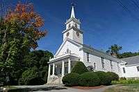
The Bolton Center Historic District is the historic center of the town of Bolton, Massachusetts. The district encompasses what is essentially a linear town center, strung out principally along Main Street (Massachusetts Route 117). Although the town's first meetinghouse (built c. 1740 and no longer extant) lay outside the current center, by the early 19th century the town's focus had moved to the main east-west road through the town (now Route 117). The district includes a variety of houses from the 18th century onward, including the house of the first town minister (c. 1741, 752 Main Street). Institutional buildings in the district include the 1853 Town House, four historic school buildings (including an 1825 one room schoolhouse), and the 1928 Colonial Revival Federated Church of Bolton.[2]
The district was listed on the National Register of Historic Places in 1996.[1]
See also
References
- 1 2 National Park Service (2010-07-09). "National Register Information System". National Register of Historic Places. National Park Service.
- ↑ "NRHP nomination for Bolton Center Historic District". Commonwealth of Massachusetts. Retrieved 2014-03-02.
External links
- Town of Bolton, MA - desc. of historic district
| Topics |  | ||||||||||||||||||||||||||||||
|---|---|---|---|---|---|---|---|---|---|---|---|---|---|---|---|---|---|---|---|---|---|---|---|---|---|---|---|---|---|---|---|
| Lists by county | |||||||||||||||||||||||||||||||
| Lists by city |
| ||||||||||||||||||||||||||||||
| Other lists | |||||||||||||||||||||||||||||||
| |||||||||||||||||||||||||||||||