Bonnet Carré Spillway
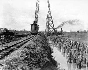
The Bonnet Carré Spillway (pronounced /'bɒni: 'kɛri:/) is a flood control operation in the Lower Mississippi Valley. Located in St. Charles Parish, Louisiana – about 12 miles (19 km) west of New Orleans – it allows floodwaters from the Mississippi River to flow into Lake Pontchartrain and thence into the Gulf of Mexico. The construction of the Spillway was completed in 1931.
Bonnet Carré Crevasse
The Bonnet Carré Crevasse was one of several levee breaches in the Bonnet Carré area in 1871.[1] Local drainage systems were unable to contain the floodwater and strong winds caused the water to enter Lake Pontchartrain and surrounding urban areas. The river levee was not restored until 1883.[2]
Overview
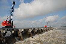
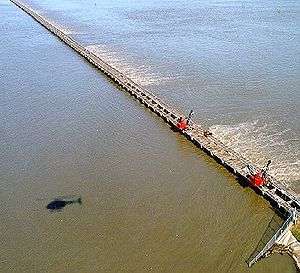
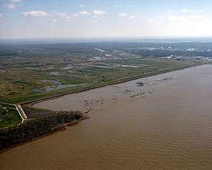
The Bonnet Carré Spillway consists of two basic components: a control structure along the east bank of the Mississippi River and a floodway that transfers the diverted flood waters to the lake.[3] The control structure is a mechanically-controlled concrete weir that extends for over a mile and a half parallel to the river. When opened, the control structure allows overflow volume to flow into Lake Pontchartrain. The lake's opening to the gulf is sufficient to absorb and dissipate any conceivable volume of flood flow. Thus, the flood surcharge portion of the water from the Mississippi is divided between the main river and the diversion channel; with the surcharge bypassing the New Orleans metropolitan area, resulting in the Mississippi being lower (through that area) than it could have been; and reducing the stress on the area's levees that line the river. Confined by guide levees, the floodway stretches nearly six miles (10 km) to Lake Pontchartrain, with a design capacity of 250,000 cu ft/s (7,100 m3/s).[4] The spillway is crossed by U.S. 61 and Interstate 10.
The spillway was built in response to the Great Mississippi Flood of 1927 that inundated much of the Mississippi River basin. It was first opened during the flood of 1937, and ten times thereafter through 2016 to lower river stages at New Orleans. The most recent opening began January 10, 2016,[5] when river levels in New Orleans were predicted to approach the flood stage of 17 feet (5.2 m).
Structure & multi-state plan
The floodgate inlet is offset into the Mississippi River bank, at a location that had seen natural flooding for at least two centuries. The concrete structure has been designed to reduce settling into the riverbank. The opening and closing of the spillway is done by lifting out up to 7000 wooden 'needles' (8" x 12" wooden beams) arranged in 350 linear bays. This is done by two rail-mounted gantry cranes atop the spillway. The number of needles removed determines the water flow into the spillway. Gaps built into each bay allow limited seepage anytime the river level reaches the bottom of the bays. Removal of all 7000 needles takes about 36 hours but is usually done over a period of several days.
The spillway is part of the United States Army Corps of Engineers' multi-state plan, called the Mississippi River and Tributaries Project (MR&T), providing flood protection for the alluvial valley between Cape Girardeau, Missouri. and the mouth of the river near Venice, Louisiana. Due to the wide expanse of the project and the complex problems involved, the plan contains an array of features. The MR&T Project provides for levees to contain flood flows, floodways such as the Bonnet Carré to redirect excess flows away from the Mississippi, and other aspects such as channel improvement and river bank stabilization, for efficient navigation and protection of the levee system. It also involves reservoirs and pumping stations for flood control drainage.[6]
History of openings
Years when the spillway was opened, number of days it remained open, peak number of bays opened, percent of bays opened, and ideal flow capacity. Ideal flow capacity is calculated by ideal rate of flow for each bay multiplied by number of bays opened; remember that the spillway has a design capacity of 250000 cu ft/s and there are 350 bays making the ideal rate of flow for each bay 714.3 cu ft/s.[7][8]
| Year | Days | Bays Opened | (%) Opened | Ideal flow capacity |
|---|---|---|---|---|
| 1937 | 48 | 285 | 81.4% | 203,571 cu ft/s |
| 1945 | 57 | 350 | 100% | 250,000 cu ft/s |
| 1950 | 38 | 350 | 100% | 250,000 cu ft/s |
| 1973 | 75 | 350 | 100% | 250,000 cu ft/s |
| 1975 | 13 | 225 | 64.3% | 160,714 cu ft/s |
| 1979 | 45 | 350 | 100% | 250,000 cu ft/s |
| 1983 | 35 | 350 | 100% | 250,000 cu ft/s |
| 1997 | 31 | 298 | 85.1% | 212,857 cu ft/s |
| 2008 | 31 | 160 | 45.7% | 114,286 cu ft/s |
| 2011 | 42 | 330 | 94.3% | 235,714 cu ft/s |
| 2016 | 22 | 210 | 60.0% | 203,000 cu ft/s |
Kugler and Kenner Cemeteries
.jpg)
There are two graveyards located in the spillway. The cemeteries containing the remains of both free and enslaved African-Americans are under several feet of sediment. When the Spillway gates are opened, the cemeteries are flooded with up to 30 feet of water diverted from the Mississippi River into Lake Pontchartrain.
According to investigative reporter Shonna Riggs, "The location of the gravesites was a mystery until the 1970's when the US Corp of Engineers was attempting to excavate a ditch in the spillway. During that process, a tombstone and casket were discovered. In 1986, the corps ordered a historical study of the spillway and discovered a second cemetery. The two cemeteries were placed on the National Register of Historic Places on 10/16/1987." According to the Louisiana Historical Preservation Society, there are 14 graves located in the Kugler Cemetery and 144 in the Kenner Cemetery. The artifacts discovered during the 1986 study included coffin furniture, coffins, grave markers, cultural remains, and human remains. The archaeological district consists of two discontinuous, but historically associated, historic cemeteries.
The cemeteries, named Kenner and Kugler, are black burial plots which appear to date from the early 1800s to 1929. The sites are located on former adjoining 19th- and early 20th-century sugar plantations in St. Charles Parish. According to oral histories, both cemeteries were dedicated burial plots on the back side of their respective plantations. The Kenner Cemetery, located on the former Roseland Plantation, was reported to be marked by iron and wooden crosses during its period of use. No such markers were confirmed archaeologically, but one granite headstone was recovered from the site. The Kugler Cemetery, located on the former Hermitage Plantation, was reported to contain iron crosses and a metal fence. One such iron cross and remnants of what could have been the fence were recovered during the 1986 archaeological investigations. At present the sites are indistinguishable from the surrounding landscape.[11]
Natural resource management
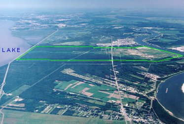
In 2007, extraction operations began on a 42-acre (170,000 m2) square section of spillway property. The 7,600-acre (31 km2) spillway, designed to divert rising water out of the Mississippi River during flooding seasons, long has been a major source of sand and clay that is used in construction projects throughout the area. But in the post-Katrina era, clay extracted from the spillway will be crucial to raising the levees in St. Charles Parish and east Jefferson Parish.
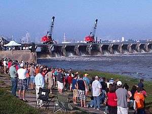
The spillway's secondary function is as a recreational area. It is used for off-road vehicles, biking, boating, hiking, hunting and fishing. It is designated as a protected wildlife management area by the Louisiana Department of Wildlife and Fisheries.[12][13] To enhance fishing in the spillway, the clay extraction area pits were filled with water and stocked with bluegill, largemouth bass, and other fish.
Diversion projects
The success of the Caernarvon Freshwater and the Davis Pond Freshwater Diversions, especially concerning wetlands maintenance more than wetlands building, has led to studies for more fresh water diversion projects. Caernarvon and Davis Pond diversions have limits, because of laws governing their operation, aimed at limiting the flow of freshwater to minimize damage to oysters.[14] The Bonnet Carré Spillway diversion would be built within the spillway, on the east bank of the Mississippi, allowing up to 25,000 cfs of fresh water and sediment diversion into Lake Pontchartrain and the Mississippi Sound. The diversion would slow or stop subsidence[15] reducing marsh loss by 10,500 acres in the next 50 years, providing fish and wildlife protection, as well as further storm surge protection. The diversion was authorized by the Water Resources Development Act of 1988 (WRDA 1988) and Congress (1990) split the cost and maintenance between the Federal Government at 75%, Louisiana at 20% and Mississippi at 5%. Louisiana and Mississippi must agree to a final project design but in July 1996 Louisiana withdrew as a sponsor and as of 2016 an agreement has not been reached.[16]
See also
- CNR Bonnet Carré Spillway-Baton Rouge Bridge
- CNR Bonnet Carré Spillway-McComb Bridge
- Kansas City Southern Bonnet Carré Spillway Bridge
- I-10 Bonnet Carré Spillway Bridge
- U.S. 61 Bonnet Carré Spillway Bridge
- Birds Point-New Madrid Floodway
- Morganza Spillway
Notes
- ↑ Rogers, J. D. (2008). "Development of the New Orleans Flood Protection System prior to Hurricane Katrina". Journal of Geotechnical and Geoenvironmental Engineering. 134 (5): 602–617. doi:10.1061/(ASCE)1090-0241(2008)134:5(602). ISSN 1090-0241.
- ↑ "Bonnet Carré Crevasse Historical Marker". StoppingPoints.com. StoppingPoints.com. 27 July 2007. Retrieved 25 October 2015.
- ↑ Army Corp of Engineers: Bonnet Carré Spillway
- ↑ Army Corps of Engineers: Annotated aerial view of spillway
- ↑ Schleifstein, Mark (2016-01-10). "Bonnet Carre Spillway opens Sunday to praise, warnings". The Times-Picayune. NOLA Media Group. Retrieved 2016-01-11.
- ↑ Army Corps of Engineers: Louisiana MR&T structures
- ↑ Matt Scallan (11 April 2008). "Previous Spillway Openings". New Orleans Times-Picayune: A–1.
- ↑ "Corps Finishes Closing Bonnet Carre Spillway". WDSU/AP. Retrieved 2008-05-08.
- ↑ "U.S. Army Corps of Engineers Team New Orleans". Archived from the original on 2011-05-21. Retrieved 2011-05-13.
- ↑ http://www.mvn.usace.army.mil/Missions/MississippiRiverFloodControl/BonnetCarreSpillwayOverview/SpillwayOperationInformation.aspx
- ↑ "Corps to check status of watery graves". Saint Charles Parish St. Charles Herald Guide. Retrieved 2008-05-15.
- ↑ "Wildlife Management Areas". Louisiana Department of Wildlife and Fisheries. Retrieved 2014-01-18.
- ↑ "Bonnet Carre Spillway". Louisiana Department of Wildlife and Fisheries. Retrieved 2014-01-18.
- ↑ NOLA: Diversion projects
- ↑ Tulane: Bonnet Carré Spillway diversion- Retrieved 2016-08-07
- ↑ USACE brochure: Bonnet Carré Spillway diversion- Retrieved 2016-08-07
External links
| Wikimedia Commons has media related to Bonnet Carré Spillway. |
- U.S. Army Corps of Engineers Bonnet Carré Spillway Official Site
- "New Orleans Flood Valve Finished", March 1931, Popular Science
Coordinates: 30°0′8″N 90°26′29″W / 30.00222°N 90.44139°W
![]() This article incorporates public domain material from the United States Army Corps of Engineers website http://wayback.archive.org/web/20110521053442/http://www.mvn.usace.army.mil/pao/BRO/Bonnet_Carre_041220.pdf.
This article incorporates public domain material from the United States Army Corps of Engineers website http://wayback.archive.org/web/20110521053442/http://www.mvn.usace.army.mil/pao/BRO/Bonnet_Carre_041220.pdf.