Boundary Cone
| Boundary Cone | |
|---|---|
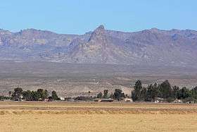 View of Boundary Cone from Mohave Valley, on the Colorado River | |
| Highest point | |
| Elevation | 3,432 ft (1,046 m) NAVD 88[1] |
| Prominence | 750 ft (229 m) [1] |
| Coordinates | 34°59′02″N 114°24′56″W / 34.983788761°N 114.415665406°WCoordinates: 34°59′02″N 114°24′56″W / 34.983788761°N 114.415665406°W [2] |
| Geography | |
 Boundary Cone
| |
| Location | Mohave County, Arizona, U.S |
| Parent range | Black Mountains |
| Topo map | USGS Boundary Cone |
| Geology | |
| Mountain type | volcanic neck[3] |
Boundary Cone is a geologic promontory located in the western foothills of the Black Mountains in Mohave County, Arizona.[4] The peak is to the east of the Mohave Valley, northeast of Needles, California, and southeast of Bullhead City. The peak is about 4 miles (6 km) southwest of the mountain community of Oatman and 12 miles (19 km) east of the Colorado River.
History
Several Indian tribes attach religious and cultural significance to Boundary Cone as well as much of the surrounding landscape. In March 2006, the Bureau of Land Management determined and the Arizona State Historic Preservation Office concurred that Boundary Cone is eligible for inclusion on the National Register of Historic Places as a property of traditional, religious, and cultural importance to several Indian tribes.[5]
Boundary Cone was a prominent landmark for early travelers in this region.
 Fort Mojave Indian Reservation, with Boundary Cone in distance
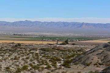 Mohave Valley, with Boundary Cone at right
References
- 1 2 "Boundary Cone, Arizona". Peakbagger.com. Retrieved 2012-04-22.
- ↑ "Boundary Cone". NGS data sheet. U.S. National Geodetic Survey. Retrieved 2016-08-15.
- ↑ Chronic, Halka (1983). Roadside Geology of Arizona. p. 85. ISBN 9780878421473.
- ↑ "Boundary Cone". Geographic Names Information System. United States Geological Survey. Retrieved 2016-08-15.
- ↑ Federal Register Notice regarding Boundary Cone, October 8, 2008. This article incorporates public domain text from this official United States government document.
| Wikimedia Commons has media related to Boundary Cone. |