Boura Mountains
| Boura Mountains | |
|---|---|
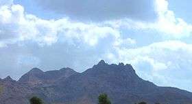 A picture of the southern part of Boura Mountains. | |
| Highest point | |
| Elevation | 1,037 m (3,402 ft) |
| Geography | |
 | |
| Country | Djibouti |
| State/Province | Ali Sabieh Region |
The Boura Mountains are a mountain range in Djibouti. With a mean peak height of 1037 metres (3,402 ft) is the eight highest point in Djibouti, the ecology of this landform is semi-desert. The mountain is located approximately 32 kilometres (20 mi) east of Ali Sabieh, 13 kilometres (8 mi) from Assamo by road. The altitude and size of the range affects its weather, with precipitation levels varying greatly and climatic conditions consisting of distinct zones. Wildlife live in the higher peaks to elevations of 1,037 m (3,402 ft). Issa Somali have a long history in the Boura Mountains.
History
Issa Somali have inhabited the area since at least 2,000 years. The French probably travelled around the Boura Mountains in 1899. The most famous town in the area is the town of Ali Adde located 2 km north. The principal languages spoken in the area are Somali
Geography
Boura Mountains is actually a cluster of mountains with two distinct summits, each about the same height. The mountain forms one of the geographic resources of the area.
Ecology
The geology of the Boura Mountains is complex. The dense mountain forest sits at an altitude of between 650–900 m above sea level, and has a mean annual rainfall of 150–250 mm. The highlands experience, as most tropical regions, two seasons; the rainy season is from mid-June to mid-September and the dry season from October to June. In addition to rainfall, the Boura Mountains receive additional precipitation in the form of fog and winter rains which sustain isolated forests of Juniperus, Buxus, Acacia, Acacia tortilis, Juniperus procera, etc. The Boura Mountains have attracted many animals, such as gazelles, birds, hamadryas baboon and black-backed jackal. Rainfall is limited, with variations based on elevation. The highlands enjoy a temperate, rainy summer with an average high temperature of 31 °C and a cool, moderately dry winter with temperatures occasionally below 13 °C.
Fauna and flora
A number of birds are found in the mountains including Egyptian vultures. Mammals include the Dorcas gazelle which is found in the Boura Mountains. The mountains are rich in plant life, including a number of different species. The vegetation changes with altitude, the mountains are covered with desert scrublands at lower elevations, growing richer and then becoming scrubland.
Climate
The climate type of Boura Mountains is tropical monsoon, located close to the equator, these mountains catch the precipitation of the monsoon winds of the Indian Ocean, resulting in a rainy season that lasts from July until mid-September. The elevation of 1,037 metres (3,402 ft). The high altitude of the high ranges of mountains which embrace it provide a pleasant climate, with refreshing cool summer nights and excellent spring, while winter days are pretty cold and the nights could reach 12°C (53°F). It is common for afternoon temperatures to be over 30 °C (85 °F) yet mornings can be extremely cooler. As a result, there is much more natural vegetation.
| Climate data for Boura Mountains | |||||||||||||
|---|---|---|---|---|---|---|---|---|---|---|---|---|---|
| Month | Jan | Feb | Mar | Apr | May | Jun | Jul | Aug | Sep | Oct | Nov | Dec | Year |
| Average high °C (°F) | 23.7 (74.7) |
25.4 (77.7) |
26.6 (79.9) |
27.0 (80.6) |
30 (86) |
33.9 (93) |
35.2 (95.4) |
32.9 (91.2) |
31.5 (88.7) |
28.1 (82.6) |
27.0 (80.6) |
25.0 (77) |
28.86 (83.95) |
| Average low °C (°F) | 13.0 (55.4) |
14.1 (57.4) |
15.5 (59.9) |
17.5 (63.5) |
20.4 (68.7) |
24.6 (76.3) |
25.8 (78.4) |
23.5 (74.3) |
19.9 (67.8) |
17.8 (64) |
16.4 (61.5) |
14.1 (57.4) |
18.55 (65.38) |
| Average precipitation mm (inches) | 6 (0.24) |
7 (0.28) |
9 (0.35) |
19 (0.75) |
11 (0.43) |
4 (0.16) |
39 (1.54) |
49 (1.93) |
45 (1.77) |
20 (0.79) |
11 (0.43) |
6 (0.24) |
226 (8.91) |
| Source: Climate Data | |||||||||||||
Hiking paths
The mountain has a strong undergrowth and it cannot be walked up from every direction. The main path starts at the east side.
References
Coordinates: 11°04′N 42°52′E / 11.067°N 42.867°E