Bradford, Vermont
| Bradford | |
|---|---|
| Town | |
|
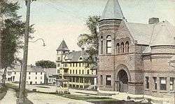
Main Street | |
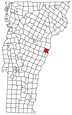 Located in Orange County, Vermont | |
 Location of Vermont with the U.S.A. | |
 Bradford Located in Orange County, Vermont | |
| Coordinates: 43°59′41″N 72°7′58″W / 43.99472°N 72.13278°WCoordinates: 43°59′41″N 72°7′58″W / 43.99472°N 72.13278°W | |
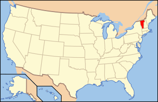
| Country | United States |
| State | Vermont |
| County | Orange |
| Chartered | 1770 |
| Area | |
| • Total | 29.9 sq mi (77.4 km2) |
| • Land | 29.8 sq mi (77.2 km2) |
| • Water | 0.1 sq mi (0.2 km2) |
| Elevation | 425 ft (263 m) |
| Population (2000) | |
| • Total | 2,619 |
| • Density | 87.8/sq mi (33.9/km2) |
| • Households | 1,028 |
| • Families | 692 |
| Time zone | EST (UTC-5) |
| • Summer (DST) | EDT (UTC-4) |
| ZIP code | 05033 |
| Area code(s) | 802 |
| FIPS code | 50-07375[1] |
| GNIS feature ID | 1462046[2] |
| Website | bradford-vt.us |
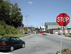
Bradford is a town in Orange County, Vermont, United States. The population was 2,797 at the 2010 census. Bradford is located on the county's eastern border, bordering both the Connecticut River and New Hampshire, and is a commercial center for some of its surrounding towns.
History
The first settler was John Hosmer in 1765. Originally called Waits Town or Waits River Town after Joseph Wait, it was changed to Mooretown when 3,000 acres (1200 hectares) were granted on May 3, 1770 by New York patent to Sir Henry Moore, 1st Baronet, who in turn conveyed them to 30 settlers. The remainder of the land was appropriated by squatters. In 1788, the name was changed by the Vermont General Assembly to Bradford.
Although the chief occupation of the town was farming, mills developed at falls on the Waits River. On October 10, 1848, the Connecticut & Passumpsic Rivers Railroad formally opened to Bradford. By 1859, when the town's population was 1,723, industries included a foundry and machine shop, two gristmills, three sawmills, a paper mill and whetstone factory. Bradford also manufactured farm implements, wooden ware and tinware.
Geography
According to the United States Census Bureau, the town has a total area of 29.9 square miles (77.4 km2), of which 29.8 square miles (77.2 km2) is land and 0.1 square mile (0.2 km2) (0.20%) is water. The Waits River flows through Bradford to its confluence with the Connecticut River, which forms the eastern boundary of the town.[3]
The town is crossed by ![]() Interstate 91,
Interstate 91, ![]() U.S. Route 5,
U.S. Route 5, ![]() Vermont Route 25, and
Vermont Route 25, and ![]() Vermont Route 25B. It is bordered by the towns of Newbury to the north, West Fairlee and Fairlee to the south, and Corinth to the west. Piermont, New Hampshire lies across the Connecticut River to the east.
Vermont Route 25B. It is bordered by the towns of Newbury to the north, West Fairlee and Fairlee to the south, and Corinth to the west. Piermont, New Hampshire lies across the Connecticut River to the east.
Demographics
| Historical population | |||
|---|---|---|---|
| Census | Pop. | %± | |
| 1790 | 654 | — | |
| 1800 | 1,064 | 62.7% | |
| 1810 | 1,302 | 22.4% | |
| 1820 | 1,411 | 8.4% | |
| 1830 | 1,507 | 6.8% | |
| 1840 | 1,655 | 9.8% | |
| 1850 | 1,723 | 4.1% | |
| 1860 | 1,689 | −2.0% | |
| 1870 | 1,492 | −11.7% | |
| 1880 | 1,520 | 1.9% | |
| 1890 | 1,429 | −6.0% | |
| 1900 | 1,338 | −6.4% | |
| 1910 | 1,372 | 2.5% | |
| 1920 | 1,422 | 3.6% | |
| 1930 | 1,235 | −13.2% | |
| 1940 | 1,507 | 22.0% | |
| 1950 | 1,551 | 2.9% | |
| 1960 | 1,619 | 4.4% | |
| 1970 | 1,527 | −5.7% | |
| 1980 | 2,191 | 43.5% | |
| 1990 | 2,522 | 15.1% | |
| 2000 | 2,619 | 3.8% | |
| 2010 | 2,797 | 6.8% | |
| Est. 2014 | 2,765 | [4] | −1.1% |
| U.S. Decennial Census[5] | |||
As of the census[1] of 2000, there were 2,619 people, 1,028 households, and 692 families residing in the town. The population density was 87.8 people per square mile (33.9/km2). There were 1,217 housing units at an average density of 40.8 per square mile (15.8/km2). The racial makeup of the town was 97.71% White, 0.46% Black or African American, 0.46% Native American, 0.23% Asian, 0.15% Pacific Islander, and 0.99% from two or more races. Hispanic or Latino of any race were 0.61% of the population.
There were 1,028 households out of which 33.8% had children under the age of 18 living with them. 51.8% were married couples living together, 12.5% had a female householder with no husband present, and 32.6% were non-families. 25.5% of all households were made up of individuals and 11.8% had someone living alone who was 65 years of age or older. The average household size was 2.48 and the average family size was 2.98.
In the town the population was spread out with 26.2% under the age of 18, 7.6% from 18 to 24, 25.5% from 25 to 44, 25.1% from 45 to 64, and 15.6% who were 65 years of age or older. The median age was 40 years. For every 100 females there were 91.0 males. For every 100 females age 18 and over, there were 88.3 males.
The median income for a household in the town was $37,270, and the median income for a family was $42,128. Males had a median income of $30,865 versus $28,857 for females. The per capita income for the town was $18,452. About 7.9% of families and 11.3% of the population were below the poverty line, including 15.5% of those under age 18 and 8.1% of those age 65 or over
Education
With a total student population of approximately 850, Bradford is home to:
- Bradford Elementary
- Oxbow High School
- River Bend Career & Technical Center
Sites of interest
Connecticut River Academy
Notable people
- Private Miles DeForrest Andross, killed defending the Alamo
- John Putnam Chapin, mayor of Chicago
- Charles Edgar Clark, captain of the USS Oregon
- Ned O'Gorman, poet and educator
- Herbert Thomas Johnson, Adjutant General of the Vermont National Guard and namesake of Camp Johnson, the state National Guard Headquarters
- Albert Sleeper, 29th governor of Michigan
- James Wilson, first American globe maker
- Jay Wright, poet
- Horace Tabor, American prospector, politician, philanthropist
- Bruce Murray, nationally-recognized potter.
References
- 1 2 "American FactFinder". United States Census Bureau. Archived from the original on 2013-09-11. Retrieved 2008-01-31.
- ↑ "US Board on Geographic Names". United States Geological Survey. 2007-10-25. Retrieved 2008-01-31.
- ↑ DeLorme (1996). Vermont Atlas & Gazetteer. Yarmouth, Maine: DeLorme. ISBN 0-89933-016-9
- ↑ "Annual Estimates of the Resident Population for Incorporated Places: April 1, 2010 to July 1, 2014". Retrieved June 4, 2015.
- ↑ "U.S. Decennial Census". United States Census Bureau. Archived from the original on May 11, 2015. Retrieved May 16, 2015.
Further reading
- A. J. Coolidge & J. B. Mansfield, A History and Description of New England, Boston, Massachusetts 1859
- Silas McKeen, A History of Bradford, Vermont; J. D. Clark & Son, Montpelier, Vermont 1875
External links
| Wikimedia Commons has media related to Bradford, Vermont. |
- Bradford Public Library
- http://www.flickr.com/photos/dougtone/sets/72157624852460842/with/4946489487/
Municipalities and communities of Orange County, Vermont, United States | ||
|---|---|---|
| Towns | 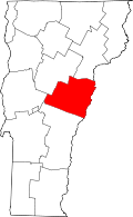 | |
| Villages | ||
| CDPs | ||
| Other communities | ||