Brańsk
| Brańsk | ||
|---|---|---|
|
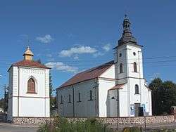
Roman Catholic church | ||
| ||
.png) Location within Bielsk County | ||
 Brańsk Location within Poland | ||
| Coordinates: 52°45′N 22°50′E / 52.750°N 22.833°E | ||
| Country |
| |
| Voivodeship | Podlaskie | |
| County | Bielsk | |
| Gmina | Brańsk (urban gmina) | |
| Town rights | 18 January 1493 | |
| Government | ||
| • Mayor | Czesław Sokołowski | |
| Area | ||
| • Total | 32.43 km2 (12.52 sq mi) | |
| Population (2007) | ||
| • Total | 3,822 | |
| • Density | 120/km2 (310/sq mi) | |
| Time zone | CET (UTC+1) | |
| • Summer (DST) | CEST (UTC+2) | |
| Postal code | 17-120 | |
| Area code(s) | +48 085 | |
| Car plates | BBI | |
| Website | http://www.bransk.podlaskie.pl | |

Brańsk [braɲsk] (Ukrainian: Бранськ or Брянськ, Brans’k or Brians’k) is an Urban Gmina (Polish: gmina miejska) (Town) in Bielsk County, Podlaskie Voivodeship. It is located north-eastern Poland.
Etymology
The name of the town comes from the river Bronka, a nearby tributary of the Nurzec River.
Geography
Location
Brańsk is located in the geographical region of Europe known as the Wysoczyzny Podlasko – Bialoruskie (English: Podlaskie and Belarus Plateau) and the mezoregion known as the Bielsk Plain (Polish: Równinę Bielską). The Nurzec River, a tributary of the Bug River, passes through Brańsk. The town covers an area of 32.43 square kilometres (12.5 sq mi).
It is located approximately:
- 140 kilometres (87.0 mi) northeast of Warsaw, the capital of Poland
- 69 kilometres (42.9 mi) southwest of Białystok, the capital of the Podlaskie Voivodeship
- 25 kilometres (15.5 mi) west of Bielsk Podlaski, the seat of Bielsk County
Climate
The region has a continental climate which is characterized by high temperatures during summer and long and frosty winters . The average amount of rainfall during the year exceeds 550 millimetres (21.7 in).
History
Specific historical events in Brańsk
13th century
On 23 June 1264 two armies met near Brańsk. The Battle of Brańsk lasted two days pitting the forces of Yotvingia, led by Komata (Kumata) against the well equipped Krakovian army led by the Duke of Krakow, Boleslaw V the Chaste.
15th century
On 18 January 1493, Brańsk received a city charter based on Magdeburg rights from the Grand Duke of Lithuania, Alexander Jagiellon. It was the first city in Podlaskie to receive such a charter.

20th century
On September 1, 1939, Germany attacked Poland and quickly overwhelmed it. Within days of the war's beginning, Brańsk suffered German bombardment. On September 17, 1939, the USSR attacked eastern Poland, and in partnership with Nazi Germany, partitioned Poland under the terms of the Nazi-Soviet Non-Aggression Pact of August 23. Brańsk along with all areas of Poland east of the Bug River was then occupied by the Soviet Union. All Polish and Jewish businesses of substance were confiscated by the Communist State. The Soviets remained in control of Brańsk until June 1941 when the Germans invaded their erstwhile Soviet allies. Hitler's German Wehrmacht (army) occupied the town and ordered the Jewish community to build a ghetto surrounded by barbed wire, to which the Jewish population (some 65% of the town) was confined. On November 8, 1942, the Jews of Brańsk were ordered to report to the town center, forced to march to the nearby town of Bielsk, and then transported by train to Treblinka. Within weeks, the vast majority were murdered by gassing at the Treblinka death camp.
Demographics
Population
Detailed data as of 31 December 2007:[1]
| Total | Women | Men | ||||
|---|---|---|---|---|---|---|
| Unit | Number | % | Number | % | Number | % |
| Population | 3,822 | 100 | 1,944 | 50.9 | 1,878 | 49.1 |
| Population Density (persons/km²) | 117.9 | 56.9 | 57.9 | |||
Income
Income data from 2005:[2]
Average per capita income: 1961.03 zł
Compared to the average per capita income:
- In the Podlaskie Voivodeship: 120.40%
- In Poland: 112.20%
Municipal government
It is the seat of Gmina Brańsk, but is not part of Gmina Brańsk.
Executive branch
The chief executive of the government is the Mayor (Polish: Burmistrz).
Legislative branch
The legislative portion of the government is the Council (Polish: Rada) composed of the President (Polish: Przewodniczšcy), the Vice President (Polish: Wiceprzewodniczšcy) and thirteen councilors.
Neighbouring political subdivisions
Brańsk is bordered by Gminy Rudka and Brańsk.
Transport
Roads and highways
Brańsk is at the intersection of a National Road and a Voivodeship Road:
- National Road
 - Zambrów - Brańsk - Bielsk Podlaski - Kleszczele - Czeremcha - Połowce Border Crossing (Belarus)
 - Voivodeship Road
 - Roszki-Wodźki - Łapy - Brańsk - Ciechanowiec
Streets
The major streets (Polish: Ulica) in Brańsk:
- Rynek
- Armii Krajowej (National Road )
- Bielska
- Binduga
- Boćkowska
- Błonie
- Jagiellońska
- Jana Pawła II (Voivodeship Road )
- Kapicy Milewskiego
- Kasztanowa
- Klonowa
- Konopnickiej
- Kościelna
- Kościuszki (Voivodeship Road )
- Mickiewicza
- Piłsudskiego
- Poniatowskiego
- Senatorska
- Sienkiewicza
- Skłodowskiej-Curie
- Szkolna
- Słowackiego
- Witosa
- Wyszyńskiego
- Ściegiennego
Public transport
Bus service
Regular bus service is provided by Państwowa Komunikacja Samochodowa (State Car Communication, PKS) via PKS Bielsk Podlaskie, PKS Białystok and PKS Siemiatycze
Rail service
The closest passenger train service is provided by Polskie Koleje Państwowe (Polish State Railways, PKP) SA from the following stations:
- Szepietowo - express and local service to Warsaw and Białystok - 28 kilometres (17.4 mi) northwest
- Bielsk Podlaski - express and local service to Siedlce and Białystok - 25 kilometres (15.5 mi) east
Economy
The land-use is as follows:[3]
- Agricultural use: 66%
- Forest land: 27%
- City: 2.34%
Major business
- Financial:Banking - Bank Spóldzielczy w Brańsku, ul.Kosciuszki 2A, 17-120 Brańsk, Poland
- Manufacturing:Plastics - Wald-Gold, ul.M.Konopnickiej 20, 17-120 Brańsk, Poland
Local attractions
Places of worship
Church of the Assumption of the Blessed Virgin Mary - Roman Catholic
- Parish serving Brańsk, Bronka, Brzeźnica, Glinnik, Jarmarkowszczyzna, Kalnica, Kiersnówek, Majerowizna, Oleksin, Otapy, Patoki, Popławy, Świrydy, Załuskie Koronne, Załuskie Kościelne[4]
- Part of the Roman Catholic Diocese of Drohiczyn
St. Simeon Stylites - Polish Orthodox
- Mission church of Church of the Apostles St. Peter and Paul in Malesze[5]
- Part of the Polish Orthodox Diocese of Warsaw-Bielsk
Nearby attractions
- Sanktuarium Matki Bożej Pojedniania w Hodyszewie (Our Lady of Hodyszewo Sanctuary) in Hodyzewo - 12 kilometres (7.5 mi) northwest
- Ossoliński Palace in Rudka - 7 kilometres (4.3 mi) west
Notable people
- Jan Klemens Branicki – Polish nobleman
- Cezary Kosiński – Polish actor
- Ignatius Kapitsa-Milewski – archivist and author
- Shimon Shkop – Jewish scholar and rabbi (1906–1920)
- Zofia Drzewiecka – Recipient of the Righteous among the Nations Medal
- Waclawa and Pawel Sobolewski – posthumous recipients of the Righteous among the Nations Medal
- Antoni Sobolewski – posthumous recipient of the Righteous among the Nations Medal
- Aleksander Sobolewski – posthumous recipient of the Righteous among the Nations Medal
Miscellanea
- The Righteous among the Nations Medal has been granted to 14 current and former residents of Brańsk by Yad Vashem[6]
External links
- Jewish cemetery in Brańsk (in Polish - English Text)
- Polish Righteous: Those Who Risked Their Lives
- Video tour of Brańsk on YouTube
References
- ↑ "Central Statistical Office (GUS) Population: Size and Structure by Administrative Division" (in Polish). 2007-12-31. Archived from the original on 2008-05-05.
- ↑ "Edytor Serwis Sp. z o.o. REGIOset Portal" (in Polish). 2005-12-31.
- ↑ "Strona Urzędu Miasta Brańsk - Brańsk Government Website" (in Polish). 2008-06-25.
- ↑ "Parafia Wniebowzięcia Nmp w Brańsku" (in Polish). 2008-08-16.
- ↑ "Dekanat Bielsk Podlaski" (in Polish). 2008-08-16.
- ↑ "Another Pole added to Righteous among the Nations - Polskie Radio". 2008-06-23.
| Urban gminas |
| _COA.svg.png) |
|---|---|---|
| Rural gminas | ||
Coordinates: 52°44′N 22°51′E / 52.733°N 22.850°E