Brattvær
| Brattvær herad | |
|---|---|
| Former Municipality | |
 | |
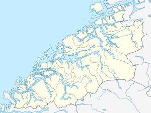 Brattvær Location in Møre og Romsdal | |
| Coordinates: 63°24′23″N 07°48′19″E / 63.40639°N 7.80528°ECoordinates: 63°24′23″N 07°48′19″E / 63.40639°N 7.80528°E | |
| Country | Norway |
| Region | Western Norway |
| County | Møre og Romsdal |
| District | Nordmøre |
| Time zone | CET (UTC+01:00) |
| • Summer (DST) | CEST (UTC+02:00) |
| ISO 3166 code | NO-1574 |
| Created from | Edøy in 1915 |
| Merged into | Smøla in 1960 |
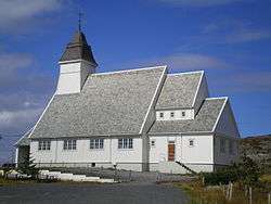
Brattvær is a former municipality in Møre og Romsdal county, Norway. It was located on the western part of the island of Smøla in the present-day municipality of Smøla. It included the area near Råket and Dyrnes. The Brattvær Church was the main church of the municipality.[1]
History
The municipality of Brattvær was established on 1 January 1915 when the large municipality of Edøy was split into three to form the new municipalities of Edøy, Brattvær, and Hopen. Initially, Brattvær had a population of 973. On 1 January 1960, the 1915 partition was reversed, reuniting the municipalities of Brattvær, Edøy, and Hopen under the new name of Smøla. Before the merger, Brattvær had a population of 1,361.[2]
References
- ↑ Store norske leksikon. "Brattvær" (in Norwegian). Retrieved 2010-12-12.
- ↑ Jukvam, Dag (1999). "Historisk oversikt over endringer i kommune- og fylkesinndelingen" (PDF) (in Norwegian). Statistisk sentralbyrå.
This article is issued from Wikipedia - version of the 4/30/2015. The text is available under the Creative Commons Attribution/Share Alike but additional terms may apply for the media files.