Brazzaville
| Brazzaville | |
|---|---|
|
Brazzaville | |
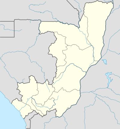 Brazzaville Map of the Republic of Congo showing Brazzaville. | |
| Coordinates: 4°16′4″S 15°17′31″E / 4.26778°S 15.29194°ECoordinates: 4°16′4″S 15°17′31″E / 4.26778°S 15.29194°E | |
| Country | Republic of the Congo |
| Capital district | Brazzaville |
| Founded | 1883 |
| Founded by | Pierre Savorgnan de Brazza |
| Government | |
| • Mayor | Hugues Ngouelondélé (nonpartisan) |
| Area | |
| • Total | 263.9 km2 (101.9 sq mi) |
| Elevation | 320 m (1,050 ft) |
| Population (2014 (Estimated))[1][2] | |
| • Total | 1,827,000 |
| • Density | 6,900/km2 (18,000/sq mi) |
| Area code(s) | 242 |
| Website |
www |
Brazzaville is the capital and largest city of the Republic of the Congo and is located on the Congo River. As of the 2007 census, it had a population of 1,373,382. The projection of the CNSEE (national statistics centre) shows an increase to 1.7 million by 2015,[1] but the projection was made before 2007 and based on a lower estimate of the population (1.26 million) than recorded in the census. The United Nations Population Division estimate for 2014 is 1.827 million. The populous city of Kinshasa (more than 10 million inhabitants in 2014),[2] capital of the Democratic Republic of the Congo, lies across the Congo River from Brazzaville. Together with Kinshasa, the combined conurbation of Kinshasa-Brazzaville has thus about 12 million inhabitants (although significant political and infrastructure challenges prevent the two cities from functioning with any meaningful connection). Over a third of the population of the Republic of Congo lives in the capital, and it is home to 40% of non-agricultural employment. It is also a financial and administrative capital.
Geography

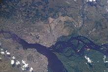
In order to distinguish between the two African countries with "Congo" in their names, the Republic of the Congo is sometimes called Congo-Brazzaville, as opposed to Congo-Kinshasa (the Democratic Republic of the Congo, known from 1971 to 1997 as Zaïre, the capital of which is Kinshasa). Kinshasa lies on the southern bank of the Congo, across from Brazzaville. This is the only place in the world where two national capital cities are situated on opposite banks of a river, within sight of each other. There have been proposals to connect the two capitals by a Brazzaville–Kinshasa Bridge.
While Kinshasa lies to the south, Brazzaville lies to the north of the Congo River. The city is 506 kilometres (314 miles) inland from the Atlantic Ocean and approximately 474 kilometres (295 miles) south of the equator. The city is a commune that is separated from the other regions of the republic; it is surrounded by the Pool Region. Around the city is are large plains. The town is relatively flat, and situated at an altitude of 317 metres (1,040 feet).
History

The city was founded on 10 September 1880 on the site of a Bateke village named Nkuna by an Italo-French explorer, Pierre Savorgnan de Brazza, after whom the city was named. The local leader, Makoko of the Téké, signed a treaty of protection with de Brazza which subjugated his lands to the French Empire. The city was built four years later in order to become a competitor with Léopoldville (now Kinshasa) which was built by the Belgians on the other side of the river. The site was occupied from October 1880 until May 1882 by a small squad of troops led by Senegalese Sergeant Malamine Camara, who prevented the land from falling into Belgian hands.
French control over the area was made official by the Berlin Conference of 1884. The city became the capital first of the French Congo, and then of French Equatorial Africa, a federation of states which encompassed Gabon, the Central African Republic and Chad. In 1924, the Congo-Océan railway was brought into service which linked Brazzaville with the port of Pointe-Noire. Construction of the railway resulted in the death of over 17,000 Africans which led to a revolt in 1928.[3]
During World War II Brazzaville, and the rest of French Equatorial Africa, remained beyond the control of Vichy France. In 1944, Brazzaville hosted a meeting of the Free French forces and representatives of France's African colonies. The resulting Brazzaville Declaration was intended to redefine the relationship between France and its African colonies after the war.
Until the 1960s, the city was divided into European (the center of the city) and African sections (Poto-Poto, Bacongo, and Makélékélé). In 1980 it became a "commune" separated from the Pool Region and divided into nine "arrondissements": Makélékélé (1), Bacongo (2), Poto-Poto (3), Moungali (4), Ouenzé (5), Talangaï (6), Mfilou (7), Madibou (8), and Djiri (9).
The city has frequently been a staging ground for wars, including conflicts between rebel and government forces and between forces of the Republic of Congo, the Democratic Republic of the Congo, and Angola. It was also the scene of bloody civil wars throughout the 1990s which resulted in thousands of civilian deaths and which forced hundreds of thousands of refugees to flee the city.
Economy
Industries present in Brazzaville include machine shops, textiles, tanning, and manufacturing. As a key port on the Congo River, the city takes deliveries of raw materials, such as rubber, wood and agricultural products. From here they are generally sent onward to Pointe-Noire for export.
As the capital city of the Republic of Congo, many companies, government organizations and NGOs have regional offices in the city. The World Health Organization has its regional office for Africa located in Brazzaville.[4]
Buildings and institutions
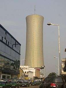
Notable buildings in the city include St Anne's Basilica, built in 1949 by Roger Erell, and known for its green tiled roof; Erell also designed a house in the city for Charles de Gaulle. Other buildings include the Nabemba Tower and the Congressional Palace. Other features include the Marien Ngouabi Mausoleum, Brazzaville Zoo and the Poto-Poto School of Painting. The United States Embassy for the Republic of the Congo is also located in Brazzaville, as is the Dutch Honorary Consulate.
The World Health Organization Regional Office for Africa is based in Brazzaville on a vast campus at the Cité du Djoué.
Climate
Brazzaville, much like neighboring Kinshasa, features a tropical wet and dry climate. Its wet season, which runs from October–May, is longer than its dry season, which covers the remaining months. Brazzaville's driest months, July and August, see on average no significant precipitation. Since Brazzaville is south of the equator, its dry season begins at around its "winter" solstice, which is the month of June. The city experiences relatively consistent temperatures throughout the course of the year.
| Climate data for Brazzaville (Maya-Maya Airport) 1961–1990, extremes 1932–present | |||||||||||||
|---|---|---|---|---|---|---|---|---|---|---|---|---|---|
| Month | Jan | Feb | Mar | Apr | May | Jun | Jul | Aug | Sep | Oct | Nov | Dec | Year |
| Record high °C (°F) | 37.5 (99.5) |
36.3 (97.3) |
37.5 (99.5) |
36.8 (98.2) |
37.3 (99.1) |
34.3 (93.7) |
33.8 (92.8) |
40.2 (104.4) |
39.5 (103.1) |
38.9 (102) |
35.8 (96.4) |
40.2 (104.4) |
40.2 (104.4) |
| Average high °C (°F) | 30.5 (86.9) |
31.3 (88.3) |
31.7 (89.1) |
31.8 (89.2) |
30.9 (87.6) |
28.4 (83.1) |
27.0 (80.6) |
28.5 (83.3) |
30.4 (86.7) |
30.8 (87.4) |
30.4 (86.7) |
30.2 (86.4) |
30.2 (86.4) |
| Daily mean °C (°F) | 26.0 (78.8) |
26.4 (79.5) |
26.7 (80.1) |
26.8 (80.2) |
26.2 (79.2) |
23.8 (74.8) |
22.4 (72.3) |
23.6 (74.5) |
25.5 (77.9) |
26.1 (79) |
25.9 (78.6) |
25.8 (78.4) |
25.4 (77.7) |
| Average low °C (°F) | 21.4 (70.5) |
21.5 (70.7) |
21.7 (71.1) |
21.9 (71.4) |
21.6 (70.9) |
19.3 (66.7) |
17.8 (64) |
18.8 (65.8) |
20.6 (69.1) |
21.4 (70.5) |
21.4 (70.5) |
21.5 (70.7) |
20.7 (69.3) |
| Record low °C (°F) | 17.0 (62.6) |
14.5 (58.1) |
17.7 (63.9) |
18.6 (65.5) |
17.0 (62.6) |
12.7 (54.9) |
10.5 (50.9) |
10.3 (50.5) |
15.2 (59.4) |
13.7 (56.7) |
18.2 (64.8) |
17.7 (63.9) |
10.3 (50.5) |
| Average precipitation mm (inches) | 160 (6.3) |
137 (5.39) |
167 (6.57) |
191 (7.52) |
118 (4.65) |
8 (0.31) |
3 (0.12) |
4 (0.16) |
34 (1.34) |
139 (5.47) |
261 (10.28) |
172 (6.77) |
1,394 (54.88) |
| Average precipitation days (≥ 1.0 mm) | 10 | 8 | 11 | 12 | 8 | 1 | 0 | 0 | 4 | 9 | 14 | 12 | 89 |
| Average relative humidity (%) | 81 | 80 | 79 | 81 | 81 | 79 | 77 | 73 | 71 | 76 | 81 | 82 | 78 |
| Mean monthly sunshine hours | 171 | 167 | 192 | 181 | 177 | 141 | 127 | 133 | 145 | 152 | 157 | 154 | 1,897 |
| Source #1: Deutscher Wetterdienst (humidity, 1951–1990)[5][6][lower-alpha 1] | |||||||||||||
| Source #2: Meteo Climat (record highs and lows)[7] | |||||||||||||
Transport
The city is home to Maya-Maya Airport which has regular flights to Pointe-Noire as well as international destinations in Africa, Europe and the Middle East.
The Congo-Ocean Railway has a station in the city and in 2014 was operating the La Gazelle train service every other day to Pointe-Noire and intermediate destinations.[8]
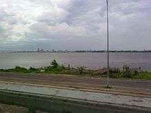
The city is also an important river port, with ferries sailing to Kinshasa and to Bangui via Impfondo. The Livingstone Falls lie on the outskirts of the city, where the Djoué River meets the Congo, rendering river transport to the coast impossible, qualifying the railway as a portage railway.
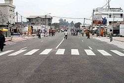
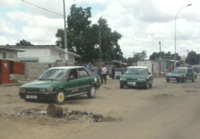
Although there is no organised public transport system privately owned buses are available in the capital.[9]
Taxis are available on every street and are easily recognized, being painted with a green body and white top, and the fare for a short trip is CF700. About twenty percent of the vehicles in Brazzaville are taxis. There are also collective taxis that drive certain routes and charge CF150.
Notable People
- Gaitana, Ukrainian singer who lived in Brazzaville for five years.
- Serge Ibaka, professional basketball player born in Brazzaville.
Twin towns and sister cities
Notes
- ↑ Station ID for Brazzaville/ Maya–Maya is 64450 Use this station ID to locate the sunshine duration
References
- 1 2 "Répartition de la population par Départements et Communes en 1984 et projetée de 2000 à 2015" (in French). Centre National de la Statistique et des Études Économiques (CNSEE), Republic of the Congo. Retrieved 27 October 2013.
- 1 2 "Monographie de la Ville de Kinshasa" (SWF) (in French). Unité de Pilotage du Processus d'Elaboration et de mise œuvre de la Stratégie pour la Réduction de la Pauvreté (UPPE-SRP). Retrieved 19 January 2007.
- ↑ http://www.bbc.co.uk/news/world-africa-14121195
- ↑ http://www.who.int/about/regions/afro/en/index.html
- ↑ "Klimatafel von Brazzaville (Flugh.) / Kongo" (PDF). Baseline climate means (1961-1990) from stations all over the world (in German). Deutscher Wetterdienst. Retrieved 24 October 2016.
- ↑ "Station 64450 Brazzaville/ Maya–Maya". Global station data 1961–1990—Sunshine Duration. Deutscher Wetterdienst. Retrieved 24 October 2016.
- ↑ "Station Brazzaville" (in French). Meteo Climat. Retrieved 24 October 2016.
- ↑ 2014 Timetable, Lonely Planet, https://www.lonelyplanet.com/thorntree/forums/africa/congo/la-gazelle-train-brazzaville-to-pointe-noire
- ↑ "Archived copy". Archived from the original on 25 January 2010. Retrieved 2014-09-27.
- Chavannes, Charles de. (1929) "Le Sergent Sénégalais Malamine." Annales de l'Académie des Sciences Coloniales, vol. 3:159-187.
- Petringa, Maria. (2006) Brazza, A Life for Africa (2006) ISBN 978-1-4259-1198-0
- Tiepolo, M. (1996) "City Profile: Brazzaville" in Cities v. 13, pp. 117–124
- Brisset-Guibert, Hervé (2007) Brazzaville petit guide historique, in the site www.presidence.cg ("palais presidentiel")
- Cultural reference: In the final scene of the 1942 film, Casablanca, it is to Brazzaville that Captain Renault (Claude Rains) suggests he and Rick (Humphrey Bogart) might escape to together for "vacation" and, as Rick counters, "the beginning of a beautiful friendship."
External links
| Wikimedia Commons has media related to Brazzaville. |
- BRAKIN, the fusion city of Brazzaville and Kinshasa, urban analysis seminar with vectorised maps of the agglomeration by TU Darmstadt, 2009
- Maria Petringa's 1997 biographical article on Savorgnan de Brazza, describing events leading to the founding of Brazzaville
 Brazzaville travel guide from Wikivoyage
All-Africa Games host cities | |
|---|---|