Bridge Mill Power Plant
|
Bridge Mill Power Plant | |
 | |
  | |
| Location | Pawtucket, Rhode Island |
|---|---|
| Coordinates | 41°52′35″N 71°23′4″W / 41.87639°N 71.38444°WCoordinates: 41°52′35″N 71°23′4″W / 41.87639°N 71.38444°W |
| Built | 1893 |
| Architect | Stone, Carpenter & Willson |
| MPS | Pawtucket MRA |
| NRHP Reference # | 83003805 [1] |
| Added to NRHP | November 18, 1983 |
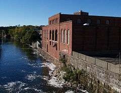
The Bridge Mill Power Plant is an historic hydroelectric plant at 25 Roosevelt Avenue in Pawtucket, Rhode Island. It is a red brick building, with sections two and three stories in height, located on the west bank of the Seekonk River. An ashlar granite retaining wall obscures a conduit which delivers water to the facility from the Pawtucket Falls Dam. The facility has three parts: a gate house, which controls the flow of water into the power house, where five turbines were located. A boiler house housed a steam generation facility which was used to generate power when the water levels were too low for hydroelectric power generation. Built in 1893, this is probably the best-preserved 19th-century hydroelectric power station in Rhode Island.[2]
The plant was listed on the National Register of Historic Register in 1983.[1]
See also
References
- 1 2 National Park Service (2007-01-23). "National Register Information System". National Register of Historic Places. National Park Service.
- ↑ "Historic Resources of Pawtucket (PDF pages 139-141)" (PDF). Rhode Island Preservation. Retrieved 2014-11-13.
| Topics | |
|---|---|
| Lists by states |
|
| Lists by insular areas | |
| Lists by associated states | |
| Other areas | |
| |