Bridgeport Downtown South Historic District
|
Bridgeport Downtown South Historic District | |
|
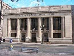
The former Mechanics & Farmers Savings Bank building | |
  | |
| Location | Roughly bounded by Elm, Cannon, Main, Gilbert, and Broad Sts., Bridgeport, Connecticut |
|---|---|
| Coordinates | 41°10′37″N 73°11′30″W / 41.17694°N 73.19167°WCoordinates: 41°10′37″N 73°11′30″W / 41.17694°N 73.19167°W |
| Area | 27 acres (11 ha) |
| Architect | Cass Gilbert |
| Architectural style | Late 19th and 20th Century Revivals, Late Victorian, Moderne |
| MPS | Downtown Bridgeport MRA |
| NRHP Reference # | 87001402[1] |
| Added to NRHP | September 3, 1987 |
The Bridgeport Downtown South Historic District is a 27-acre (11 ha) historic district in Bridgeport, Connecticut that was listed on the National Register of Historic Places in 1987. The district is roughly bordered on the east by Main and Middle Streets, on the north by Elm Street, the west by Broad Street, and the south by Cesar Batalla Way. It includes 50 contributing buildings and 12 non-contributing buildings.[1] The district includes one building, 149-165 State Street, designed by noted architect Cass Gilbert. Other notable buildings include the separately-listed Barnum Museum, Sterling Block-Bishop Arcade and United Illuminating Company Building, as well as McLevy Hall, the former city hall and county courthouse.[2]
See also
- Bridgeport Downtown North Historic District
- National Register of Historic Places listings in Bridgeport, Connecticut
References
- 1 2 National Park Service (2009-03-13). "National Register Information System". National Register of Historic Places. National Park Service.
- ↑ J. Paul Loether and John Herzan (March 20, 1987). "NRHP Inventory-Nomination: Bridgeport Downtown South Historic District" (PDF). National Park Service. (continuation of MRA document) and accompanying 15 photos, from 1986
| Topics | |
|---|---|
| Lists by states |
|
| Lists by insular areas | |
| Lists by associated states | |
| Other areas | |
| |
This article is issued from Wikipedia - version of the 11/28/2016. The text is available under the Creative Commons Attribution/Share Alike but additional terms may apply for the media files.