Briey
| Briey | ||
|---|---|---|
 | ||
| ||
 Briey | ||
|
Location within Grand Est region  Briey | ||
| Coordinates: 49°14′58″N 5°56′25″E / 49.2494°N 5.9403°ECoordinates: 49°14′58″N 5°56′25″E / 49.2494°N 5.9403°E | ||
| Country | France | |
| Region | Grand Est | |
| Department | Meurthe-et-Moselle | |
| Arrondissement | Briey | |
| Canton | Briey | |
| Intercommunality | Pays de Briey | |
| Government | ||
| • Mayor (2008–2014) | Guy Vattier | |
| Area1 | 27.13 km2 (10.47 sq mi) | |
| Population (2009)2 | 5,464 | |
| • Density | 200/km2 (520/sq mi) | |
| Time zone | CET (UTC+1) | |
| • Summer (DST) | CEST (UTC+2) | |
| INSEE/Postal code | 54099 / 54150 | |
| Elevation |
200–300 m (660–980 ft) (avg. 240 m or 790 ft) | |
|
1 French Land Register data, which excludes lakes, ponds, glaciers > 1 km² (0.386 sq mi or 247 acres) and river estuaries. 2 Population without double counting: residents of multiple communes (e.g., students and military personnel) only counted once. | ||

Briey (French pronunciation: [bʁijɛ]) is a commune in the Meurthe-et-Moselle department in northeastern France.
It is located above and in a steep section of the valley of the little River Woigot, some thirty kilometres to the west of the autoroute that connects Metz with Luxembourg. The town itself had a gently declining population through much of the twentieth century, but the level has recently recovered to around 5,000.
Geography
Briey forms a part of an extensive grouping of once heavily industrialised towns that also includes Jœuf and Homécourt, along with Hagondange, Amnéville and Rombas in the adjacent department.
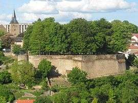
The town is arranged into four principal quarters, and traversed by the Woigot (itself a tributary of the Orne). North of the river, Briey-Haut (Upper Briey), the area centred on the former medieval citadel, stretches out towards the villages of Mance and Moutier, and overhangs Briey-Bas (Lower Briey), which occupies the banks of the Woigot. The steeply angled “grand-rue” (“Main Street”) connects the two areas of the town, which elsewhere are separated by a cliff-face garden. South of the valley is Briey-les-Hauts, another “high town”, facing the villages of Lantéfontaine and Valleroy. Beyond Briey-Haut, the fourth quarter is Briey-en-Forêt, a 1960s development dominated by Le Corbusier’s “Cité Radieuse”, a substantial apartment block, which displays an architectural assertiveness characteristic of its time: the Cité Radieuse has frequently struggled to attract residents, triggering aesthetic and political controversy since first it emerged from the surrounding woodland.
History
The name "Briey" comes from the Celtic word "Briga", which denotes a fortress. There is a record of the Counts of Bar having held a castle here in 1072. Briey received town privileges in 1263. The turbulent years following the traumas of 1348/1349 and resulting sudden shifts in economic power were marked by an upsurge of violence across the region, and in 1369 Briey was burned out by a force from nearby Metz.
The increasing fragility of the old middle kingdom (culminating with its disappearance in 1477) created areas of political uncertainty on both sides of the Rhine and ushered in several centuries of warfare which tended, at least till 1871, to involve on the one side France and on the other side various neighbouring countries whose leaders did not wish France to become larger. Briey found itself captured by Charles the Bold in 1475, ravaged by Protestants in 1591, and captured by a Swedish army in 1635. No doubt the relative strength of the natural defensive position of the old citadel preserved Briey from yet more frequent devastations, but it was nonetheless reportedly occupied briefly by a Russian army during the final days of the Napoleonic Wars in 1815.
In 1801 Briey became a sub-prefecture in the Moselle department. However, after 1871 most of the Moselle department became part of the German Empire under the terms of the Treaty of Frankfurt. The former French department ceased to exist and its residuum, including Briey, was integrated into a new department of Meurthe-et-Moselle. When Lorraine was recovered by France in 1919 it was decided not to return Briey to its former department. Thus in terms of departmental boundaries, the town remains administratively separated from the eastern portion of the Briey Basin.
Population
| Historical population | ||
|---|---|---|
| Year | Pop. | ±% |
| 1793 | 1,802 | — |
| 1800 | 1,403 | −22.1% |
| 1806 | 1,784 | +27.2% |
| 1821 | 1,627 | −8.8% |
| 1836 | 1,730 | +6.3% |
| 1841 | 1,938 | +12.0% |
| 1861 | 1,886 | −2.7% |
| 1866 | 1,876 | −0.5% |
| 1872 | 1,996 | +6.4% |
| 1876 | 2,139 | +7.2% |
| 1881 | 2,131 | −0.4% |
| 1886 | 2,143 | +0.6% |
| 1891 | 2,033 | −5.1% |
| 1896 | 2,001 | −1.6% |
| 1901 | 2,226 | +11.2% |
| 1906 | 2,630 | +18.1% |
| 1911 | 2,894 | +10.0% |
| 1921 | 2,686 | −7.2% |
| 1926 | 2,666 | −0.7% |
| 1931 | 2,804 | +5.2% |
| 1936 | 2,779 | −0.9% |
| 1946 | 2,909 | +4.7% |
| 1954 | 3,443 | +18.4% |
| 1962 | 5,391 | +56.6% |
| 1968 | 4,966 | −7.9% |
| 1975 | 5,352 | +7.8% |
| 1982 | 4,357 | −18.6% |
| 1990 | 4,514 | +3.6% |
| 1999 | 4,858 | +7.6% |
| 2006 | 5,128 | +5.6% |
| 2009 | 5,464 | +6.6% |
Economy
At the beginning of the twentieth century the Briey Basin was one of Europe’s leading steel producing regions: in the 1970s the Hagondange-Briey agglomeration still had a population of above 130,000, although by 1990 this figure had fallen to 112,000.
Intensive heavy industrialisation is now a receding memory, and the service sector has provided the principal sources of employment growth in recent years, with increasing numbers of the working-age residents commuting to nearby Metz or Luxembourg.
See also
References
| Wikimedia Commons has media related to Briey (Meurthe-et-Moselle). |