Bronx Kill
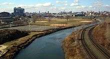

The Bronx Kill is a narrow strait in New York City delineating the southernmost extent of the Bronx and separating it from Randalls Island. It connects the Harlem River to the East River.[1]
History
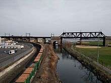
Originally, the Bronx Kill was a sizeable waterway, approximately 600 feet (180 m) in width. There were also plans by the War Department to dredge a 24-foot (7.3 m) deep channel, 480 feet (150 m) in width, to improve navigation and reduce tidal currents. For this reason, in the early 20th century the New York Connecting Railroad built a movable bridge across the Bronx Kill on the approach to the Hell Gate Bridge.[2][3] Similarly, the truss bridge of the Triborough Bridge across the Bronx Kill was designed to be convertible to a lift bridge.[4] However, much of the Bronx Kill was later filled in to expand the parkland on Randalls Island.
Navigation
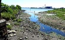
The Bronx Kill offers a venue for kayakers and other human-powered boaters without the worry of larger vessel traffic. Canoe and kayak expeditions through the waterway begin on the Harlem River, near the Third Avenue Bridge. Crossings must be well timed for the tides, to ensure both the correct current direction and sufficient water height: at low water, parts of the Bronx Kill entirely bottom out, revealing muddy stretches, and assorted junk. There is also low air draft under the Randalls Island Connector.[5] Consequently, no commercial vessels navigate the kill, with local businesses mostly opting instead for road and rail transport, including the Oak Point Link along its north bank.
21st century
In 2001, the New York Power Authority offered to construct a pedestrian bridge linking the Bronx with Randalls Island—part of the agency's remuneration to the community for building two new power plants in the South Bronx.[6] That plan, however, fell by the wayside when local officials argued that an improved Triborough Bridge path would be sufficient. The state authority instead paid for energy efficiency measures in the borough as a whole, including a green roof on the Bronx County Courthouse.
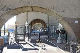
Following years of negotiation for land with the operators of the Harlem River Rail Yard on the north bank of the Kill,[7] the Randalls Island Connector was constructed across the Kill to provide pedestrian and bicycle access between the island and the Port Morris neighborhood of the Bronx and to the South Bronx Greenway.[8] The connector opened November 2015.[9]
A 2006 plan for a water park—the first in the nation for a large city—on the northwest corner of Randalls Island was controversial. Announced by the Giuliani administration as a $48 million, 15-acre (61,000 m2) project, the proposal expanded to encompass 26 acres (110,000 m2) at a projected cost of $168 million before being cancelled in 2007.[10]
See also
References
- ↑ Kadinsky, Sergey (2016) Hidden Waters of New York City Countryman Press. Pp. 85-87 ISBN 978-1-58157-355-8
- ↑ Ammann, O.H. (August 1917). "The Hell Gate Arch Bridge and Approaches of the New York Connecting Railroad over the East River in New York City". Proceedings of the American Society of Civil Engineers. 43: 1763–1767.
- ↑ Harlem, NY-NJ Quadrangle (Map). 1:62,500. 15 Minute Series (Topographic). United States Geological Survey. 1900. § SW. Retrieved 2010-02-21.
- ↑ Rastorfer, Darl (2000). Six Bridges: The Legacy of Othmar H. Ammann. New Haven: Yale University Press. p. 166. ISBN 0-300-08047-6.
- ↑ Bindley, Katherine (September 6, 2008). "On the Water, a Tight Fit and Nervous Boaters". The New York Times. Retrieved 2009-09-18.
- ↑ Koh, Eun Lee (March 4, 2001). "Not Merely a Footbridge, but a Path to a Rare Oasis". The New York Times. Retrieved 2010-02-21.
- ↑ "Pact will let city build bridge to Randall's Island". Mott Haven Herald. Retrieved 2015-11-17.
- ↑ "South Bronx Greenway". New York City Economic Development Corporation. Retrieved 2010-10-14.
- ↑ "Long-Awaited Randall's Island Connector to Open This Weekend". DNA Info. Retrieved 2015-11-17.
- ↑ Danis, Kirsten (September 22, 2007). "City Cancels Plans for Randalls Island Water Park". Daily News. New York. Retrieved 2011-02-24.
External links
Coordinates: 40°47′57″N 73°55′11″W / 40.79917°N 73.91972°W