Brown Bear Seamount
- Not to be confused with Bear Seamount.
| Brown Bear Seamount | |
|---|---|
|
Brown Bear Seamount on the left, Axial Seamount in the center. | |
| Summit depth | 1,410 m (4,626 ft)[1] |
| Height | 1,100 m (3,609 ft) |
| Location | |
| Coordinates | 46°02.40′N 130°27.60′W / 46.04000°N 130.46000°WCoordinates: 46°02.40′N 130°27.60′W / 46.04000°N 130.46000°W |
| Geology | |
| Type | Seamount (underwater volcano), hotspot volcano |
| Last eruption | 1998 |
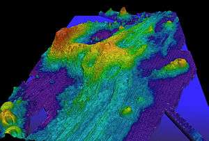
Brown Bear Seamount is a seamount (underwater volcano) approximately 300 mi (483 km) west of the coast of Oregon. It is connected to the larger Axial Seamount by a small ridge. Brown Bear Seamount was created by the Cobb hotspot, and is located on the near west of the Juan de Fuca Ridge. It has not been affected by ocean spreading as much as its neighbor, and is therefore not quite as geologically complex. Brown is the second youngest volcano in the chain, after Axial. No eruptions are known.
References
External links
This article is issued from Wikipedia - version of the 12/28/2015. The text is available under the Creative Commons Attribution/Share Alike but additional terms may apply for the media files.