Bucasia, Queensland
| Bucasia Mackay, Queensland | |||||||||||||
|---|---|---|---|---|---|---|---|---|---|---|---|---|---|
 Bucasia | |||||||||||||
| Coordinates | 21°01′52″S 149°09′35″E / 21.03111°S 149.15972°ECoordinates: 21°01′52″S 149°09′35″E / 21.03111°S 149.15972°E | ||||||||||||
| Population | 4,257 (2011 census)[1] | ||||||||||||
| Postcode(s) | 4750 | ||||||||||||
| Location |
| ||||||||||||
| LGA(s) | Mackay Region | ||||||||||||
| State electorate(s) | Whitsunday | ||||||||||||
| Federal Division(s) | Dawson | ||||||||||||
| |||||||||||||
Bucasia is a town and now one of the largest suburbs of Mackay in the Mackay Region, Queensland, Australia.[2][3] In the 2011 census, Bucasia had a population of 4,257 people.[1]
Geography
Bucasia is a northern coastal suburb of Mackay. The coastline forms its eastern boundary. Eimeo Creek forms the south-east boundary. The largest residential area is along the sandy beachfront with a second residential area along the road to Mackay. The bulk of the locality is used for growing sugarcane and tropical fruit, while some of the locality (particularly surrounding the creeks) is left as swampy wetlands.[4][5]
History
_Bucas.tiff.jpg)
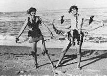
In 1874, Bucasia was originally called Marara but was later named Seaview. In 1938, it was decided that there were too many places called Seaview and so it was renamed Bucasia after Father Pierre-Marie (Paul) Bucas, the first Roman Catholic priest in Mackay.[5][6]
Starting in 1874, Father Bucas acquired 1680 acres of land through a series of purchases in present-day Bucasia, which he used to establish a community for displaced Aborigines. He also established the St Joseph's orphanage, operated by the Sisters of St Joseph until 1880, after which it was run by the Sisters of Mercy. In 1884, concerns about malaria resulted in the orphans being relocated in 1885 to the Meteor Park orphanage near Rockhampton (later known as Neerkol).[5][6][7][8] The swamp in the west of the Bucasia locality is still known as Orphanage Swamp.[9]
Over time, Bucasia developed as a holiday area but has now become a permanent residential area.[10]
Bucasia State School opened on 29 January 1985.[11]
In 1988, a memorial to Father Bucas was unveiled on Bucasia Esplanade.[6]
In 2008, the Mackay Regional Council constructed a waste water treatment plant in Bucasia, serving the northern suburbs. The two basin sequencing batch reactor can process up to 4 megalitres per day.[12]
In 2015, illegal tree clearing occurred on Bucasia foreshore, a problem in many coastal communities where foreshore trees block residential views. The trees were planted to stabilise the dunes, protect the beach, and provide habitat for wildlife.[13]
Amenities
The beach has a northly aspect with views to the Cumberland Islands. It is protected from strong winds and is one of Mackay's most popular beaches.[10] The beach is a nesting site for the flatback turtle with an average of 16 nests each year.[14]
Bucasia State School at 76 Kemp Street is a government co-educational primary school (Prep to Year 6).[15][16] In 2014, the school had 329 students with 20 teachers (19 equivalent full-time).[17]
References
- 1 2 Australian Bureau of Statistics (31 October 2012). "Bucasia". 2011 Census QuickStats. Retrieved 16 October 2015.
- ↑ "Bucasia - town (entry 4859)". Queensland Place Names. Queensland Government. Retrieved 18 October 2015.
- ↑ "Bucasia - suburb (entry 46766)". Queensland Place Names. Queensland Government. Retrieved 18 October 2015.
- ↑ "Queensland Globe". State of Queensland. Retrieved 18 October 2015.
- 1 2 3 "Bucasia". Queensland Places. Centre for the Government of Queensland, University of Queensland. Retrieved 18 October 2015.
- 1 2 3 "St Joseph's Orphanage Cemetery (Bucasia)". Mackay Historical Society and Museum. 27 December 2011. Retrieved 18 October 2015.
- ↑ "OBITUARY.". Daily Mercury (Mackay, Qld. : 1906 - 1954). Mackay, Qld.: National Library of Australia. 24 October 1930. p. 6. Retrieved 18 October 2015.
- ↑ "St Joseph's Orphanage, Bucasia (1874 - 1885)". Queensland Government. Retrieved 18 October 2015.
- ↑ "Orphanage Swamp (entry 25585)". Queensland Place Names. Queensland Government. Retrieved 18 October 2015.
- 1 2 "Bucasia". Mackay Regional Council. Retrieved 18 October 2015.
- ↑ "Opening and closing dates of Queensland Schools". Queensland Government. Retrieved 16 October 2015.
- ↑ Smyth, Matt (June 2015). "Process issues encountered when using sugar syrup at Bucasia WWTP" (PDF). 39th Annual WIOA Queensland Water Industry Operations Conference and Exhibition. Retrieved 18 October 2015.
- ↑ "Illegal tree clearing at Bucasia Beach". Mackay Regional Council. 22 April 2015. Retrieved 18 October 2015.
- ↑ "Morning of fun for young coast carers". Mackay Regional Council. Retrieved 18 October 2015.
- ↑ "Our school". Bucasia State School. Retrieved 18 October 2015.
- ↑ "Enrolling at our school". Bucasia State School. Retrieved 18 October 2015.
- ↑ "2014 School Annual Report" (PDF). Bucasia State School. Retrieved 18 October 2015.
External links
![]() Media related to Bucasia, Queensland at Wikimedia Commons
Media related to Bucasia, Queensland at Wikimedia Commons