C. David Campbell Field
| C. David Campbell Field Corsicana Municipal Airport | |||||||||||||||
|---|---|---|---|---|---|---|---|---|---|---|---|---|---|---|---|
|
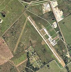
USGS aerial image, 2006 | |||||||||||||||
| IATA: CRS – ICAO: KCRS – FAA LID: CRS | |||||||||||||||
| Summary | |||||||||||||||
| Airport type | Public | ||||||||||||||
| Owner | City of Corsicana | ||||||||||||||
| Serves | Corsicana, Texas | ||||||||||||||
| Elevation AMSL | 449 ft / 137 m | ||||||||||||||
| Coordinates | 32°01′41″N 096°24′02″W / 32.02806°N 96.40056°W | ||||||||||||||
| Map | |||||||||||||||
 KCRS Location of C. David Campbell Field | |||||||||||||||
| Runways | |||||||||||||||
| |||||||||||||||
| Statistics (2010) | |||||||||||||||
| |||||||||||||||
C. David Campbell Field, also known as Corsicana Municipal Airport (IATA: CRS, ICAO: KCRS, FAA LID: CRS) is a city-owned public-use airport located within the city limits of Corsicana, in Navarro County, Texas, United States. The airport is five nautical miles (9 km) southeast of the city's central business district.[1] It provides general aviation service.
History
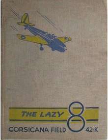
Opened on 1 April 1941 with 2,000' all-way turf runway. Known as Corsicana Field. Assigned to United States Army Air Forces Gulf Coast Training Center (later Central Flying Training Command) as a primary (level 1) pilot training airfield. had six local axillary airfields for emergency and overflow landings.
Began training United States Army Air Corps flying cadets under contract to Air Activities of Texas under 301st Flying Training Detachment. Flying training was performed with Fairchild PT-19s as the primary trainer. Also had several PT-17 Stearmans and a few old A-3 Curtiss Falcons assigned.
Inactivated on 16 October 1944 with the drawdown of AAFTC's pilot training program. Declared surplus and turned over to the Army Corps of Engineers on 30 September 1945. Eventually discharged to the War Assets Administration (WAA) and became a civil airport. [3] [4] [5]
Facilities and aircraft
C. David Campbell Field-Corsicana Municipal Airport covers an area of 166 acres (67 ha) at an elevation of 449 feet (137 m) above mean sea level. It has two runways: 14/32 is 5,004 by 75 feet (1,525 x 23 m) with an asphalt surface; 2/20 is 3,200 by 75 feet (975 x 23 m) with a turf surface.[1]
For the 12-month period ending May 5, 2010, the airport had 7,800 general aviation aircraft operations, an average of 21 per day. At that time there were 49 aircraft based at this airport: 86% single-engine, 6% multi-engine, 6% helicopter and 2% ultralight.[1]
See also
References
- 1 2 3 4 FAA Airport Master Record for CRS (Form 5010 PDF). Federal Aviation Administration. Effective 29 July 2010.
- ↑ Corsicana Municipal Airport. City of Corsica. Accessed 17 August 2010.
- ↑
 This article incorporates public domain material from the Air Force Historical Research Agency website http://www.afhra.af.mil/.
 - ↑ Shaw, Frederick J. (2004), Locating Air Force Base Sites History’s Legacy, Air Force History and Museums Program, United States Air Force, Washington DC, 2004.
- ↑ Manning, Thomas A. (2005), History of Air Education and Training Command, 1942–2002. Office of History and Research, Headquarters, AETC, Randolph AFB, Texas ASIN: B000NYX3PC
| Wikimedia Commons has media related to Corsicana Field. |
External links
- FAA Terminal Procedures for CRS, effective December 8, 2016
- Resources for this airport:
- FAA airport information for CRS
- AirNav airport information for KCRS
- ASN accident history for CRS
- FlightAware airport information and live flight tracker
- NOAA/NWS latest weather observations
- SkyVector aeronautical chart, Terminal Procedures
| Flying Training |
|  | ||||||
|---|---|---|---|---|---|---|---|---|
| Technical Training |
| |||||||