Conyca Geodrone
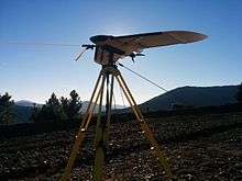
Geodrone working on The mestas. Doing the 3d terrain model of a mountain road.
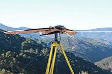
Geodrone working on The mestas. Doing the 3d terrain model of a mountain road.
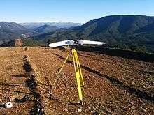
Geodrone working on The mestas. Doing the 3d terrain model of a mountain road.
The Conyca Geodrome is a 1.5m fixed-wing drone that specializes in topography and photogrametric applications. It has all the legal requirements to operate in Spain. The system has totally autonomous take-off and landing operations, can present 3D terrain models with 4 cm resolution accuracy at 100 m height, and can take orthophotos. Although this system has been orientated to topography, there are surveillance and precision agriculture versions than can use infrared and hyperspectral cameras.
Data sheet
MTOW: 2000 g
Cruise speed: 20 m/s
Max speed: 30 m/s
Autonomy: 1h
Max area: 130 Ha
Power: 625 W
Processor: 32-bit ARM Cortex® M4 Processor
External links
This article is issued from Wikipedia - version of the 3/24/2015. The text is available under the Creative Commons Attribution/Share Alike but additional terms may apply for the media files.