Cachoeira dos Índios
| Belém do Cachoeira dos Índios | |||
|---|---|---|---|
| Municipality | |||
| The Municipality of Cachoeira dos Índios | |||
 | |||
| |||
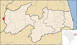 Location of Cachoeira dos Índios in the State of Paraíba | |||
| Coordinates: 06°55′37″S 38°40′26″W / 6.92694°S 38.67389°WCoordinates: 06°55′37″S 38°40′26″W / 6.92694°S 38.67389°W | |||
| Country |
| ||
| Region | Northeast | ||
| State |
| ||
| Government | |||
| • Mayor | Francisco Dantas Ricarte (DEM) | ||
| Area | |||
| • Total | 172.906 km2 (66.759 sq mi) | ||
| Population (2008)[1] | |||
| • Total | 8,620 | ||
| • Density | 47.5/km2 (123/sq mi) | ||
| Time zone | UTC-3 (UTC-3) | ||
| HDI (2000) | 0.577 – medium[2] | ||


Cachoeira dos Índios is the westernmost municipality in the Brazilian state of Paraíba.
References
- ↑ IBGE 2008 statistics
- ↑ "Archived copy". Archived from the original on 2009-10-03. Retrieved 2009-12-17. - UNDP
This article is issued from Wikipedia - version of the 11/12/2016. The text is available under the Creative Commons Attribution/Share Alike but additional terms may apply for the media files.