Cadotte Pass
| Cadotte Pass | |
|---|---|
| Elevation | 6,073 ft (1,851 m) |
| Location | Lewis and Clark County, Montana, United States |
| Range | Rocky Mountains |
| Coordinates | 47°05′58″N 112°23′37″W / 47.09944°N 112.39361°W |
| Topo map | USGS Cadotte Pass (MT) |
Cadotte Pass, known in the mid to late 1800s as Cadotte's Pass, is a pass in the Rocky Mountains located on the Continental Divide in the U.S. state of Montana. Pierre Cadotte, a white settler at Fort Benton, Montana, first explored the pass in 1851.[1] Isaac Stevens, Territorial Governor of the Montana Territory, named the pass after Cadotte in 1853.[2] The pass is 6,073 feet (1,851 m) above sea level.[3]
See also
Cited references
- ↑ Stevens, Isaac I. (1855). Reports of Explorations and Surveys to Ascertain the Most Practicable and Economical Route for a Railroad From the Mississippi River to the Pacific Ocean. Volume 1. Washington, D.C.: Beverly Tucker, Printer. p. 27.
- ↑ Thrapp, Dan L. (1988). Encyclopedia of Frontier Biography. Lincoln, Neb.: University of Nebraska Press. p. 209. ISBN 9780803294172.
- ↑ "Cadotte Pass". Geographic Names Information System. United States Geological Survey.
Municipalities and communities of Lewis and Clark County, Montana, United States | ||
|---|---|---|
| City | 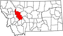 | |
| Town | ||
| CDPs | ||
| Other unincorporated communities | ||
This article is issued from Wikipedia - version of the 6/7/2016. The text is available under the Creative Commons Attribution/Share Alike but additional terms may apply for the media files.