Cairo Historic District
|
Cairo Historic District | |
|
Downtown Cairo | |
  | |
| Location | Roughly bounded by Park, 33rd, Sycamore, 21st, Cedar, and 4th Sts., and the Ohio River, Cairo, Illinois |
|---|---|
| Coordinates | 37°0′20″N 89°10′27″W / 37.00556°N 89.17417°WCoordinates: 37°0′20″N 89°10′27″W / 37.00556°N 89.17417°W |
| Area | 0.3 acres (0.12 ha) |
| NRHP Reference # | 79000815[1] |
| Added to NRHP | January 26, 1979 |
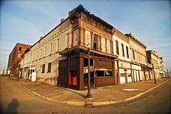
The Cairo Historic District is a historic district encompassing a large section of Cairo, Illinois. The district is roughly bounded by Park, 33rd, Sycamore, 21st, Cedar, and 4th Streets and the Ohio River; it includes most areas of Cairo developed by 1890, save for two sections which are almost entirely renovated or deteriorated. The district includes roughly 980 buildings, including both commercial and residential areas. Cairo served as a transportation and trade center in the 1800s due to its location at the confluence of the Ohio and Mississippi Rivers and its status as the southern terminus of the Illinois Central Railroad. However, the city suffered severe population decline and urban decay in the 20th century, and even by the 1970s, parts of the district were described as "beginning to assume the appearance of a ghost town".[2]
The district was added to the National Register of Historic Places on January 26, 1979.[1]
References
- 1 2 National Park Service (2010-07-09). "National Register Information System". National Register of Historic Places. National Park Service.
- ↑ Wagner, Robert (February 15, 1977). "National Register of Historic Places Inventory - Nomination Form: Cairo Historic District" (PDF). National Park Service. Retrieved January 16, 2014.
| Wikimedia Commons has media related to Cairo Historic District. |
| Topics | |
|---|---|
| Lists by states |
|
| Lists by insular areas | |
| Lists by associated states | |
| Other areas | |
| |