Cairo Metro
|
| |
| Overview | |
|---|---|
| Native name | مترو أنفاق القاهرة |
| Owner | National Authority for Tunnels (Egyptian state)[1] |
| Locale | Greater Cairo, Egypt |
| Transit type | Rapid transit |
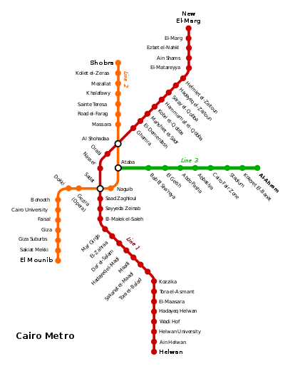
| Number of lines | 3 |
| Number of stations | 61 |
| Daily ridership | 3.6 million[2] |
| Annual ridership | 1.314 billion (FY2015)[3] |
| Website | Cairo Metro (English) |
| Operation | |
| Began operation | 27 September 1987[4] |
| Operator(s) | Cairo Metro - The Egyptian Co. for Metro Management & Operation[5] |
| Character |
Mixed Underground, At-grade and Elevated |
| Technical | |
| System length | 77.9 km (48.4 mi)[4] |
| Track gauge | 1,435 mm (4 ft 8 1⁄2 in) standard gauge |
| Electrification |
Line 1: Overhead line,1.5 kV DC[6] Line 2: Third rail, 750 V DC[7] Line 3: Third rail |
The Cairo Metro (Arabic: مترو أنفاق القاهرة Metro Anfāq al-Qāhirah, lit. "Cairo Tunnel Metro" or مترو الأنفاق pronounced [ˈmetɾo lʔænˈfæːʔ]) is the first rapid transit system in Greater Cairo, Egypt and the first of only two full-fledged metro systems in Africa and only four in the Arab world.[8][9] It was opened in 1987 as Line 1 from Helwan to Ramsis square with a length of 29 kilometres (18.0 mi).[10] As of 2014, the Cairo Metro has 61 stations (mostly At-grade), of which 3 are transfer stations, with a total length of 77.9 kilometres (48.4 mi). The system consists of three operational lines numbered from 1 to 3. As of 2013, the metro carried nearly 4 million passengers per day.[2]
The Cairo Metro is run by the National Authority for Tunnels. The lines use standard gauge (1,435 mm (4 ft 8 1⁄2 in)).
Operations

.jpg)
Since 1989, the middle two cars (4th and 5th) of each train are reserved for women[11] (the 5th car becomes mixed-use after 21:00). There are blue signs at every station that signify the position of these cars. These cars are used as an option for women who do not wish to ride with men in the same car; however, women can still ride other cars freely. This policy was introduced for protection of women from sexual harassment by men.[12]
Cairo Metro operates from 05:00 till 01:00 (except during Ramadan, when it operates from 05:00 till 02:00), with the remaining hours reserved for maintenance work.[13]
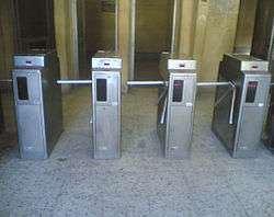
The ticket price is EGP 1.00 for each journey (about € 0.11, or $ 0.14, average exchange rate for 2013), regardless of distance.[14]
Network
| Line | Termini | Opened | Latest extension |
Length | Stations |
|---|---|---|---|---|---|
| 1 | Helwan - El Marg[15] | 1987 | 1999 | 44.3 km[10] | 35[15][16] |
| 2 | Shobra El Kheima - El Mounib[15] | 1996 | 2005 | 21.6 km[17][18] | 20[15][16] |
| 3 | Attaba - Al Ahram | 2012 | 7 May 2014 | 12.0 km[19] | 9[19] |
| TOTAL: | 77.9 km[4] | 61[15][Note 1] | |||
Line 1
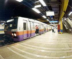
Line 1 (blue) is the oldest line of the Cairo Metro, with its first 29-kilometre (18 mi) segment having opened in 1987.[10] The line is 44.3-kilometre (27.5 mi) long,[10] and serves 35 stations. This line carries trains with 3 units (9 train cars),[10] which have a headway of 3:30 to 4 minutes, and a maximum speed of 80 km/h (50 mph).[10] The line can carry 60,000 passengers per hour in each direction.[20]
Line 1 had a train driving simulator supplied by Transurb Technirail that won the international tender issued by Cairo Metro in December 2011.[21]
Line 2
Line 2 (red) is the second line of the Cairo Metro. The line is 21.6-kilometre (13.4 mi) long,[17] of which 13 kilometres (8 mi) is in tunnels. It serves 20 stations, of which 12 are underground.[17] It is mostly in bored tunnel, with two exceptions: a short section at the northern end approaching Shubra El Kheima which is elevated, and a section just south of this by cut-and-cover. Line 2 uses the third rail electrification system instead of the overhead line used in the first line.[22] The communication extension for line 2 was provided by Alcatel in 2005.[23]
The minimum headway for the line is 2 minutes 40 seconds to 3 minutes.
Line 2 has a simulator installed in Shubra since 2002 which was delivered by French company CORYS.
The first tunnel to be built under the Nile River carries line 2 across the river.[24]
Line 3
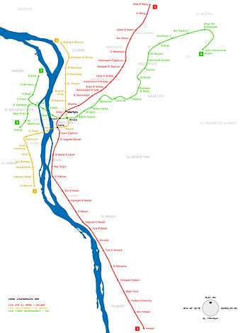
Line 3 (green) presently operates from Attaba to Ahram (Heliopolis), with construction under way for the remaining line to the northwest of Greater Cairo. Eventually it will link Cairo International Airport all the way to Cairo University and Imbaba. The line will cross under the two branches of the River Nile, as does Line 2. The total length of the line will be approximately 50 kilometres (31 mi), most of which in bored tunnel, and will be implemented in four phases.[25]
Phase 1 from Attaba station to Abbassia station opened on 21 February 2012,[26] with five stations and a total length of 4.3 kilometres (2.7 mi).[9][19] Phase 2 to Al Ahram Station was opened on the 7 May 2014 by Adly Mansour,[27][28] with four additional stations and an added length of 7.7 kilometres (4.8 mi),[19] for a total length of 12.0 kilometres (7.5 mi).
History
Background
As the biggest and most densely populated city in Africa, and the Arab World, the case for a metro in Greater Cairo was strong. In 1987 that population stood at 10 million residents, not counting the two million or so commuters who came into Cairo every day to work.[29] The capacity of Cairo's public transport infrastructure was around 20,000 passengers/hour, which increased to 60,000 after the construction of the Metro. In 1990 a study was conducted for the future needs of the city and showed there was a need for about 8.4 million journeys by public transport and 2.7 million journeys by other modes, such as taxi and car. The actual public transport capacity is 4.9 million journeys/day, 3.5 million short of the actual requirement. This has led to a 50% increase in the number of taxis on the streets with subsequent increases in traffic congestion in the city.[30]
Proposed plans
The idea of a metro was first proposed in the 1930s by engineer Saiyed Abdel Wahed of the Egyptian Railway Authority,[31] however, the idea did not progress. Following the Egyptian Revolution of 1952, there was renewed interest in the idea. In 1954 French experts made a report about the future of the transportation in Egypt. They proposed a metro encompassing two lanes, one 12 km long lane connecting Bab al-Louq and Ismailia and a second 5 km lane connecting Boulaq and Abou al-Ela Castle. They also proposed that there should be one company in charge of all transportation systems.[31]
Later on multiple experts came to Egypt regarding that project: Soviet experts in 1956, Japanese experts in 1960 and French experts in 1962, which concluded the following: The creation of a metro system with multiple lines. The first is a 5 km line connecting Helwan with El-Marg going under the Kasr el Eini street and Ramses Street.[31] The second line would be from Sayeda Zainab to Shobra going under Downtown Cairo and would be 9.5 km long.[31] The third would be from Giza to Abbaseya and would be 11.5 km long. The fourth would be from Al Awqaf to the Castle and would be 6.7 km long.[31]
In 1964 British experts advised the creation of a metro line from Bab El Louk to Shubra.[32] In 1966 Japanese experts advised the creation of a lane between Helwan and El Marg and another one going through Mohandessin, Heliopolis and 26 of July street, for a total of 26 km.[32] Lastly, in 1969, the government approved the need for a study showing the needed capacity for Cairo's transportation system.[32] The Egyptian Ministry of Transport issued an international tender for the creation of the study. Eight companies applied and the French company Sufreto won the tender on 20 September 1970.[33] The study was finished in 1973 and included mainly the study of the population development in Cairo and its needs for transportation capacity in 1980,1985 and 1990.[34] It concluded the necessity for three lines in greater Cairo to solve the transportation problem. The first line would use the already available railways (Helwan-Bab El luk and Al Laymoun Bridge-El Marg) and connect them through a metro. It would be in total 43 km long. The second line would be 13.5 km and connect Shubra El-Kheima and Bulaq going through Ramses Street and Tahrir Square. The third line would go from El Darasa to Imbaba and would be in total 10 km long.[35]
The priority for the project was the first line which would reduce 30% of the daily transport to and from Cairo and would incorporate pre-existing rail infrastructure.[35] The detailed study of the construction took 6 years from 1975 to 1981.[35] A tender was made for the construction of the metro and the Egyptian-French company Entra Nevra Arabco won it and had the task of constructing the metro system.[36]
Construction works
The construction of Line 1 started in 1982 after the French government agreed on giving Egypt the necessary loan. The first section was opened on 27 September 1987[4] and the line was completed in 1989 connecting Helwan with El Marg and consisting of 33 stations with a total length of 43 km of which 4.7 km underground.[37] In 1999, New El Marg station was added to the northern end of the line, bringing its total length to 44.3 km. Helwan University station was built between Wadi Houf and Ain Helwan stations.[22]
Cairo's metro network was greatly expanded in the mid-1990s with the building of Line 2, from Shoubra El Kheima to Cairo University, with an extension to Giza. The line includes the first tunnel under the Nile.[38][39] The construction of the line was finished in October 2000, and it was later extended to El Mounib.[38]
Future
Line 4 (October-Oasis Highway - the Police Academy)
Line 4 is planned to run from Haram District to the New Cairo district, connecting Greater Cairo from West to East. It will cross the two branches of the Nile river, and have a total length of 24 kilometres (14.9 mi).[8][9]
Phase 1 of the project will run from El-Malek El-Saleh Station (Interchange with Line 1) to the October-Oasis Highway Station with a total length of 18 km, passing through Giza Railway Station (Interchange with Line 2);[40][41] the original plan for phase 1 was for it to start from El-Malek El-Saleh Station and end at the Grand Egyptian Museum Station with a total length of 10 km, but the Ministry of Roads & Transportation decided to extend the Line in their efforts to further connect the Governorate of 6 October to the Greater Cairo Area; phase 1 also includes the plan to connect the end of Line 4 to the suburbs of 6 October mainly through executing The October 6th Tram system (The O6T) which will be by using a Tram-train system supplied with the Alstom Regio-Citadis trams. This phase will have 15 stations to be constructed with a duration of 6.5 years.[22] Phase 1 stations will be equipped with automatic fare collection system and platform screen doors, and will include elevators for the use of disabled passengers.[22]
Phase 1 bidding has been postponed until May 2015 to enable Japan International Cooperation Agency (JICA) to complete the feasibility study and to resolve other issues with the construction starts by 2015 or 2016 according to Ismail El-Nagdy, Chairman of National Authority for Tunnels with Japan International Cooperation Agency financing $1.2 billion loan while Egyptian government covering the rest of $2.4 billion.[40][41][42][43]
Phase 2 is set to begin in 2014 starting from El-Malek El-Saleh Station passing through Magra El-Oyoun street and Salah El-Din Citadel in Salah Salem street and ending at the 6th District Station (beginning of Nasr City district) with a completion date set at October 2018.[8]
Phase 3 is set to begin in 2015 starting from the 6th District Station and ending at Makram Ebeid Station running through Mustafa El-Nahas street in bored tunnels under the existing old tram system, taking it as a guide and ultimately deconstructing the old railway and paving the path it occupied increasing the street by two lanes in each direction which is critically needed to lighten the traffic congestion in the area. This phase has a completion date set at October 2019.
Phase 4, the final phase, has a starting date set in 2017 where it will start from Makram Ebeid Station with bored tunnels running through Doctor Hassan El-Sherif street and all the way under Ahmed El-Zomor street reaching the end of the line and making it complete at the Police Academy Station.[8]
Line 4 is expected to be fully operational by October 2020.[8]
The New Cairo Monorail
This project has been proposed by private investors and awaiting approval from the government with a plan to connect Line 3 with Line 4 through a route which is mostly parallel to the Ring Road's eastern arc, therefore covering New Cairo from north to south starting at the Cairo International Airport and ending at the beginning of the Cairo-Ain Sokhna Highway, where the government is currently planning to build a major bus station to serve those traveling to the eastern part of the country. The project has an estimated cost of $750 million and a completion date set at 2020.
Proposed stations are:
- Cairo International Airport
- The Governmental Complex
- Naguib Mahfouz
- Police Academy
- The 5th Settlement
- Katameya
- Eastern Cairo Bus Station
Long term plans
A transportation study of the Greater Cairo region was completed in 1999. It recommended the implementation of a six line system consisting of lines 1, 2 and 3 (existing), and lines 4, 5 and 6. The completed Metro Network would be capable of serving most of the densely populated areas in the Greater Cairo region, which was much in need of a comprehensive mass transit system. The plans include interchange stations between the six metro lines and would also provides interchange facilities with existing main railway stations, the airport, and bus stations.
The six planned metro lines aim to meet the transportation demands of the Greater Cairo area up to the year 2022. However, the actual construction and implementation schedule will be restricted by available funding, and it is likely that the timetable will slip.
Line 5 would be half-circular line connecting lines 1, 2, 3 and 4, running from Nasr City to Port Said Street and Shubra El Kheima. It would have a length of 20 kilometres (12 mi), entirely within bored tunnels.[8][9]
Line 6 would stretch from Shubra in the north until the Maadi and Helwan districts in the south. It would run from Ataba Station (Interchange with both Line 2 and Line 3) through El Kalaa street in bored tunnels to Salah Eldin Citadel Station (Interchange with Line 4) and moving on from there to both districts via bored tunnels using the existing route El-Mahager Railway as a guide through both Maadi and Helwan. This Line has a length of 19 kilometres (12 mi).[8][9]
See also
- List of Cairo Metro stations
- List of metro systems
- Template:Suburban railways in Africa
Notes
- ↑ Counting transfer stations only once.
References
- ↑ "TWINNING PROJECT FICHE - Assistance to the Egyptian Metro Company (ECM) in Reforming Railway Safety Regulations, Procedures and Practices" (PDF). Retrieved 4 August 2014.
- 1 2 Sood, Suemedha (15 March 2013). "Subway systems by the numbers". BBC. Retrieved 2014-07-28.
- ↑ See:
- "A look at the Cairo metro system". The National. Retrieved 2016-01-31. (Figure extrapolated from 3.6 million average daily boardings)
- "Statistics [see first and second figures – e.g. List of Current and Expected Ridership for Cairo Metro from 2009/2010 until 2019/2020]" (in Arabic). Cairo Metro. Retrieved 2014-11-17.
- 1 2 3 4 "Cairo". metrobits.org. Retrieved 4 August 2014.
- ↑ "About Company". Cairo Metro. Retrieved 2014-07-31.
- ↑ Barrow, Keith (14 March 2014). "Cairo to order new trains for metro Line 1". International Railway Journal. Simmons-Boardman Publishing Inc. Retrieved 23 January 2015.
- ↑ Banerjee, M.K.; El Hoda, N. (October 1998). "Review of the automatic train control system for Cairo Metro line 2". Power Engineering Journal. IET. 12 (5). doi:10.1049/pe:19980506. ISSN 0950-3366. Retrieved 25 January 2015.
- 1 2 3 4 5 6 7 "Cairo Metro, Egypt". Railway-Technology.com. Kable. Retrieved 2014-06-26.
- 1 2 3 4 5 "Cairo". UrbanRail.Net. Retrieved 2014-06-26.
- 1 2 3 4 5 6 "First Line Working". Cairo Metro, Inc. Retrieved 2014-06-27.
- ↑ Boskovitch, Angela (12 May 2015). "Photo Essay: Cairo's Transit Woes". Carnegie Endowment for International Peace. Retrieved 4 June 2016.
- ↑ Cowell, Alan (15 January 1990). "Cairo Journal; For Women Only: A Train Car Safe From Men". The New York Times. Retrieved 2014-06-27.
- ↑ Hebeishy, Reda (July 30, 2014). "Metro lines' working hours return Thursday to 20h instead of 21h". thecairopost.com. Alyoum Alsabea. Retrieved 14 August 2014.
- ↑ "Getting Around Cairo". U.S. News & World Report Travel. U.S. News & World Report. Retrieved 14 August 2014.
- 1 2 3 4 5 "Metro lines". Cairo Metro, Inc. Retrieved 2014-06-27.
- 1 2 "FAQ". Cairo Metro, Inc. Retrieved 2014-06-27.
- 1 2 3 "Line 2". National Authority for Tunnels. Retrieved 2014-06-28.
- ↑ El-Nahhas, Fathalla M. (2006). "Tunnelling and Supported Deep Excavations in the Greater Cairo" (pdf). Int. Symposium on Utilization of Underground Space in Urban Areas: 5. Retrieved 2014-06-28.
- 1 2 3 4 "Line 3". National Authority for Tunnels. Retrieved 2014-06-19.
- ↑ Metro Al Anfaq 32
- ↑ "Transurb Technirail Wins Contract to Develop a Driving Simulator for Cairo Metro in Egypt". railway-technology.com. Retrieved 8 August 2014.
- 1 2 3 4 "National Authority for Tunnels - EIA Study for Greater Cairo Metro Line No.4 Phase 1 - Final Report" (PDF). nurhosting.com. Environics. Retrieved 30 June 2014.
- ↑ "Alcatel extends the communications infrastructure of Cairo's metro line 2". Paris: Alcatel Lucent. 26 April 2005. Retrieved 2008-10-27.
- ↑ "Egypt Digs First Tunnel Under Nile". Associated Press News Archive. Associated Press. March 3, 1998. Retrieved 14 August 2014.
- ↑ Abeer Saady (May–June 2007). "Cairo's Metro Gets Bigger & Better". German-Arab chamber of industry and commerce. Retrieved 2008-10-27.
- ↑ "VINCI : Opening of Phase 1 of Line 3 of the Cairo metro". 4-traders.com. Surperformance. 22 February 2012. Retrieved 2014-06-27.
- ↑ "New Abbasiya-Heliopolis metro line opens in Cairo". Ahram Online. 7 May 2014. Retrieved 2014-06-03.
- ↑ "Cairo metro Line 3 extension opens". Railway Gazette International. 8 May 2014. Retrieved 2014-06-27.
- ↑ Metro Al Anfaq 11
- ↑ Metro Al Anfaq 14
- 1 2 3 4 5 Metro Al Anfaq 15
- 1 2 3 Metro Al Anfaq 16
- ↑ Metro Al Anfaq 17
- ↑ Metro Al Anfaq 18
- 1 2 3 Metro Al Anfaq 19
- ↑ Metro Al Anfaq 20
- ↑ "Line 1". National Authority for Tunnels. Retrieved 2014-05-24.
- 1 2 "Greater Cairo Metro Network". Egyptian Tunneling Society. 15 April 2007. Retrieved 2008-10-20.
- ↑ "Cairo's metro goes under Nile". BBC News. 19 April 1999. Retrieved 2008-10-28.
- 1 2 "Egypt begins Cairo Metro Line 4's Phase I in FY15". zawya.com. Zawya. Retrieved 30 June 2014.
- 1 2 "Egypt to begin Cairo Metro Line 4 in 2015". TradeArabia Business News Information. Retrieved 30 June 2014.
- ↑ "Cairo Metro". Railways Africa. 2 December 2014. Retrieved 25 January 2015.
- ↑ Briginshaw, David (14 November 2014). "Egypt allocates funds to expand Cairo metro". International Railway Journal. Simmons-Boardman Publishing Inc. Retrieved 22 January 2015.
- Other references
Bibliography
- Salama, Saiyed (1987). Metro Al Anfaq. Dar Al Maaref. ISBN 977-02-2155-4.
External links
| Wikimedia Commons has media related to Cairo Metro. |
- Cairo Metro – official website (English)
- National Authority for Tunnels – official website (English)
- Cairo at UrbanRail.Net
- Cairo Metro (International Tunnelling Association)
- Cairo Metro Stations Chart at VirtualTourist.com
- Some hi-res pictures from inside the Cairo Metro
| Metro | 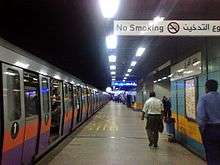 | ||||||
|---|---|---|---|---|---|---|---|
| Trams |
| ||||||
| Trolleybuses |
| ||||||
| Line 1 |
| |
|---|---|---|
| Line 2 |
| |
| Line 3 |
| |
[[Category:1500 V DC railway