Calapooia River
| Calapooia River | |
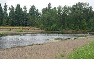 The Calapooia River at its confluence with the Willamette River, Albany | |
| Name origin: For the Kalapuya people of the Willamette Valley [1] | |
| Country | United States |
|---|---|
| State | Oregon |
| County | Linn |
| Source | Cascade Range |
| - elevation | 4,552 ft (1,387 m) [2] |
| - coordinates | 44°15′54″N 122°19′25″W / 44.26500°N 122.32361°W [3] |
| Mouth | Willamette River |
| - elevation | 180 ft (55 m) [3] |
| - coordinates | 44°38′20″N 123°6′36″W / 44.63889°N 123.11000°WCoordinates: 44°38′20″N 123°6′36″W / 44.63889°N 123.11000°W [3] |
| Length | 80 mi (129 km) [4] |
| Basin | 374 sq mi (969 km2) [4] |
| Discharge | |
| - average | 898 cu ft/s (25 m3/s) [4] |
 Location of the mouth of the Calapooia River in Oregon
| |
The Calapooia River is an 80-mile (130 km) tributary of the Willamette River in the U.S. state of Oregon.[4]
The Calapooia flows generally northwest from its source in the Cascade Range near Tidbits Mountain. In its upper reaches, it passes through parts of the Willamette National Forest. Further downstream, it flows through Holley then Crawfordsville and Brownsville in the Willamette Valley before joining the Willamette at Albany. The city of Tangent is also near the river on a branch of one of its downstream tributaries, Lake Creek. The confluence of the two rivers is about 120 miles (190 km) by water from where the Willamette joins the Columbia River[5]
The Calapooia was named for the Kalapuya (also spelled Calapooia), a tribe of Native Americans.[1]
Tributaries
Named tributaries of the river from source to mouth are Eighteen, Treadwell, and United States creeks followed by the North Fork Calapooia River. Then come King, Potts, Barrett, Washout, McKinley and Blue creeks. Further downstream are Bigs, Fox, Sweet Honey, Cedar, Pugh, Sawyer, and Brush creeks. Finally come Warren, Butte, Lake, and Oak creeks.[5]
See also
References
- 1 2 McArthur, Lewis A.; McArthur, Lewis L. (2003) [1928]. Oregon Geographic Names (7th ed.). Portland, Oregon: Oregon Historical Society Press. pp. 137–38. ISBN 0-87595-277-1.
- ↑ Source elevation derived from Google Earth search using GNIS source coordinates.
- 1 2 3 "Calapooia River". Geographic Names Information System (GNIS). United States Geological Survey. November 28, 1980. Retrieved August 8, 2010.
- 1 2 3 4 Palmer, Tim (2014). Field Guide to Oregon Rivers. Corvallis: Oregon State University Press. pp. 175–76. ISBN 978-0-87071-627-0.
- 1 2 "United States Topographic Map". United States Geological Survey. Retrieved January 28, 2016 – via ACME Mapper. The map includes mile markers along the Calapooia and Willamette rivers.
External links
![]() Media related to Calapooia River at Wikimedia Commons
Media related to Calapooia River at Wikimedia Commons