Campodolcino
| Campodolcino | |
|---|---|
| Comune | |
| Comune di Campodolcino | |
 | |
 Campodolcino Location of Campodolcino in Italy | |
| Coordinates: 46°24′N 9°21′E / 46.400°N 9.350°ECoordinates: 46°24′N 9°21′E / 46.400°N 9.350°E | |
| Country | Italy |
| Region | Lombardy |
| Province / Metropolitan city | Province of Sondrio (SO) |
| Frazioni | Tini, Strarleggia, Fraciscio, Motta, Corti, Acero, Pietra, Prestone, Portarezza, Gualdera |
| Government | |
| • Mayor |
Emilio Guanella (elected 2004-06-13) |
| Area | |
| • Total | 48.3 km2 (18.6 sq mi) |
| Elevation | 1,071 m (3,514 ft) |
| Population (Dec. 2004) | |
| • Total | 1,077 |
| • Density | 22/km2 (58/sq mi) |
| Demonym(s) | Campodolcinesi |
| Time zone | CET (UTC+1) |
| • Summer (DST) | CEST (UTC+2) |
| Postal code | 23021 |
| Dialing code | 0343 |
| Website | Official website |
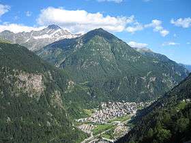
Campodolcino (German: Gampolschin) is a comune (municipality) in the Province of Sondrio in the Italian region Lombardy, located about 100 kilometres (62 mi) north of Milan and about 50 kilometres (31 mi) northwest of Sondrio, on the border with Switzerland. As of 31 December 2004, it had a population of 1,077 and an area of 48.3 square kilometres (18.6 sq mi).[1]
The municipality of Campodolcino contains the frazioni (subdivisions, mainly villages and hamlets) Fraciscio, Motta (the site of the Shrine of Our Lady of Europe), Strarleggia and Tini.
Campodolcino borders the following municipalities: Madesimo, Mesocco (Switzerland), Piuro, San Giacomo Filippo.
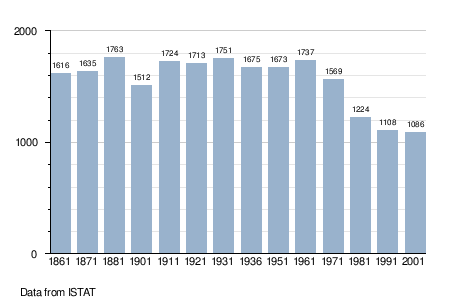
Demographic evolution
References
External links
This article is issued from Wikipedia - version of the 11/7/2016. The text is available under the Creative Commons Attribution/Share Alike but additional terms may apply for the media files.