Campsie Fells
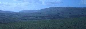
The Campsie Fells (also known as the Campsies) are a range of hills in central Scotland, stretching east to west from Denny Muir to Dumgoyne, in Stirlingshire and overlooking Strathkelvin to the south. The southern extent of the range fall within East Dunbartonshire. The range overlooks the villages of Strathblane, Blanefield and Lennoxtown to the south; Killearn to the west; Fintry and Strathendrick to the north. The Fintry Hills lie further to the north; Kilpatrick Hills lie to the west and the Kilsyth Hills to the east.
The Earl's Seat is the highest point of the Campsie Fells, measuring 578 m (1896 ft).[1] On the top of the Earl's Seat is a trig point. Two main ways of climbing the Earl's Seat are by going past Dumgoyne from the Glengoyne Distillery or going up the Fin Glen from Clachan of Campsie.
The name is taken from one of the individual hills in the range, called Campsie; meaning "crooked fairy hill", from the Scottish Gaelic cam, meaning crooked, and sìth meaning fairy. "Fell" originates from the Old Norse word fjal, meaning hill.
Erosion along the line of a geological fault known as the Campsie Fault has left tiers of rock representing some 30 lava flows which date from the Carboniferous period. The headwaters of the River Carron rise in the Campsies.
The Campsie Fells have cemented their place in history as the birthplace of Scottish skiing, when W.W. Naismith of Glasgow skied the area, becoming the first ever man to ski in Scotland in March 1892.
References
- ↑ "Earl's Seat". Gazetteer for Scotland. Retrieved 20 January 2013.
External links
- Computer-generated virtual panoramas Earl's Seat Index
Coordinates: 56°01′N 4°18′W / 56.017°N 4.300°W